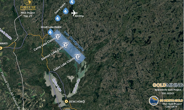
CAMP LAKE - Der's gold.... up der - in dos - flat lands.
Was just sifting ( really old ) intel on,
CABIN LAKE CLAIMS. Cabin Lake - is a term to describe all claims with in.
Where do i think the ( 100,000 ton / big grams ) are located ? CAMP LAKE. The furthest claims block nearest - power plant.
Not Cabin Lake.
Where did Rover perform most of their - work ?
Cabin Lake zone - - Andrew zone - north and south - - Beaver zone ( aside of Cabin Lake )
Bugow zone - is also referred as - -
Andrew south. ( other old report i have open )
PAGE - 30 - History The area surrounding the
Camp Lake deposit was first staked in 1938 by the B and M Syndicate of Winnipeg. They carried out trenching on the east shore of Camp Lake, but then allowed the claims to lapse.
The area was re-staked in 1944 and 1945, and the claims were purchased by American Yellowknife Gold Mines in 1945.
A 20-hole (614 metre) drill program was carried out with encouraging results; Snare River Mines was formed to develop the property. In 1954,
Tarbell Mines purchased the assets of Snare River Gold Mines, which included the Camp Lake claims (in June of 1954).
Tarbell Mines re-examined the core. The claims were eventually controlled by
Anglo United Development Corporation, who, in 1965, drilled a total of
44 holes totalling 4,370 metres. The results of this drilling, along with earlier work, resulted in a published reserve of
101,600 tonnes at an average grade of 22.3 grams per tonne gold.
In 1974, eighteen holes totalling
1,473 metres were drilled on the property and this resulted in a drop in the reported reserve to
39,235 tonnes at an average grade of 15.8 grams per tonne gold.
In 1975, part of the
area was flooded, and this resulted in a further reduction in the published reserve by over 18,288 tonnes.
The leases surrounding the deposit expired in 1995, and the area was re-staked at that time as the CEO claims by Hawkeye Gold International Incorporated, the current owners.
In
1996 further geology and geophysics were carried out (AR 083831).
During 1997, a 179 line-km airborne magnetic and EM survey, geological mapping and prospecting were carried out. One chip sample assayed
45.3 g/t Au over a width of 0.6 metres; ten samples out of 198 assayed greater than 0.5 g/t Au (AR 084006).
Two previously unknown areas of mineralization were discovered.
LINK - https://www.google.com/url?sa=t&rct=j&q=&esrc=s&source=web&cd=&cad=rja&uact=8&ved=2ahUKEwjT49jtgqL6AhVjrIkEHdzvCDcQFnoECAwQAQ&url=http%3A%2F%2Flibrary.assembly.gov.nt.ca%2F2007%2FITI%2F02-0023748-07.pdf&usg=AOvVaw0XfWhMBvoTTZUCca7X4Sem -----------------------------------------------------------------------------------------------------------------------------
OWN ASSESSMENT -
- Perhaps confusion between - CABIN + CAMP ( never name two locations with similar names )
- Camp Lake - should've bene the target zone -
- Bigger gram gold - 15 - 20 grams
TURNING POINT -
Tarbell Mines - re-examined the cores. ( they most likely missed gold in other geology )
Kinf of like... only assay the sulphides.... ( chop out and send in only select portions ) save $$$
WHO STEPS IN AFTER - CORES RE-EXAMINED ?
Anglo United Devlopment -
What do they amass ?
101,600 tons @ 22.3 grams.
There's the - true 100,000 ton gold target )
What happens over the years with - next up - explorers ?
Gold grams reduce
Tons reduce
Plausable cause ?
Maybe - insufficent assaying - select cores only assayed - not all - gold went into solution
There's a chloric alteration in this region.
Sometimes fire assay won't register all the gold present -
Again... the turning point ? Tarbell Mines re-examined the cores.
DO we have -dejavu ? Rover findinggold outside of - sulphides ?
Which suggests - only sulphides were examined ?
And.... what if gold is in solution - chlor - auric ?
CAMP STORY PLAYS OUT - The depoist continues to reduce - even with - flooding which inhibited access to the claims
and ... most likely atrributed to the loss of - tonnage to be validated - documented.
------------------------------------------------------------------------------------------------------------------------------
Fast Forward - Cabin Lake - is chosen to further explore -
Andrew = north + south is aside of - Cabin Lake zone
Beaver - immediate north of, Camp zone.
What's interesting is.... Older reports - speak of, Andrew south zone as the = Bugow.
Which is most likely - the south end of the -
large outcrop. Other historical reports - claim there's a
satalite claim 400m south of, Andrew South. So visualize the large out crop - south tip - 400m south of this.
That sounds an aweful lot like -
Cabin Lake. This in my opinion - would be.... present day - Cabin zone.
Now.... there is another name for this claim - but... i'll keep it out of hte picture as not to confuse too much... yeah... it's a good name.
Sum it up...? Camp Lake - furthest North - near power plant - has bigger gold grams.
Tarbell Mines did a double take on the -cores.
Suddenly - Anglo united is there with - bells on thier toes -
Big Gold is found -
What did these two companies do differently ? Was it the reassaying ?
This is the knowledge base that is quite important - but an unknown -
A knowledge base that -
future or current - exploration should adopt.
Cheers.....
p.s.
if.... i've errored - please do chime in and correct -
Forward - thanks...
