(TheNewswire)


-
Phase 1 drilling program has now been completed for a total of 46 drill holes for 7,888 meters with final assays still pending.
-
Upon final receipt of all assays the company will compile a 43-101 resource estimate resource at Lone Star deposit.
-
44.2m @ 1.5% CuEq from 65.8m (incl. 19.8m @ 2.8% CuEq) (LS21-001)
-
22.1m @ 1.4% CuEq from 140.4m (incl. 8.5m @ 2.6% CuEq) (LS21-001)
-
15.5m @ 5.0% CuEq from 48.3m (incl. 2.6m @ 26.1% CuEq) (LS21-002)
Vancouver, B.C. Canada – TheNewswire - June 8, 2022; Belmont Resources Inc. (“Belmont”), (or the “Company”), (TSX.V: BEA; FSE: L3L2) is pleased to announce the completion its Phase I 7,888 meter drill program along with the latest drill results from the Belmont-Marquee JV Lone Star copper-gold project in Washington State.
George Sookochoff, President & CEO commented, “When drilling on the Lone Star started on November 17, 2021, our initial plans were for a 2,500 meter drill program. But as drilling progressed and we continued to receive good drill results as we extended the historic resource envelope, we let the drilling go on for an additional 5,388 meters, and we weren’t disappointed with that decision. With drilling now complete we look forward to delivering an updated and robust 43-101 compliant resource estimate for the Lone Star deposit.”
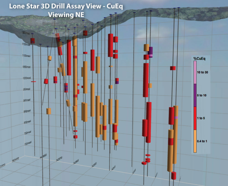
Click Image To View Full Size
Lone Star 2021-22 Drill Intercepts (CuEq >.04%)
Significant results from the latest batch of assays include:
o LS21-022: 35.1m @ 1.0% CuEq from 41.2m inc. 4.6m @ 2.8% CuEq.
o LS21-022: 79.9m @ 0.9% CuEq from 97.5m inc. 7.6m @ 3.2% CuEq.
o LS21-023: 24.4m @ 0.8% CuEq from 138.7m
o LS21-024: 25.3m @ 0.8% CuEq from 50.3m
o LS21-025: 58.2m @ 0.8% CuEq from 140.5m inc. 5.2m @ 2.2% CuEq
o LS21-027: 10.7m @ 3.1% CuEq from 111.6m inc. 5.2m @ 5.4% CuEq
o LS21-027: 6.3m @ 2.3% CuEq from 226.0m
o LS21-030: 30.5m @ 1.2% CuEq from 25.6m inc. 13.1m @ 2.0% CuEq
o LS21-031: 6.1m @ 1.6% CuEq
o LS21-031: 23.8m @ 1.0% CuEq from 157.6m inc. 11.0m @ 1.4% CuEq
o LS21-039: 70.7m @ 1.0% CuEq from 134.1m inc. 3.4m @ 14.3% CuEq
o LS21-039: 9.5m @ 1.9% CuEq from 230.7m
1.True widths of the reported mineralized intervals have not been determined.
2.Assumptions used in USD for the copper equivalent calculation were metal prices of $4.00/lb. Copper, $1,800/oz Gold, $20/oz Silver, and recovery is assumed to be 100% given the level of metallurgical test data available. The following equation was used to calculate copper equivalence: CuEq = Copper (%) + (Gold (g/t) x 0.656) + (Silver (g/t) x 0.00729).
The Lone Star deposit is interpreted to have elements of structural and stratigraphic control with an overprinting porphyry copper system. Structurally stacked ‘tectonic’ lenses of east dipping, closely spaced, overlapping en echelon zones of VMS-style massive sulphide have been structurally emplaced during thrusting over the basal serpentinite unit.
At least eight individual zones have been interpreted and these zones range from 1-18 metres thick. Porphyry and hydrothermal fluids utilised the pre-existing structural architecture to deposit copper-gold mineralisation subsequent to the earlier thrusting event.
Structurally controlled epithermal gold mineralisation, discordant with early base metal mineralisation, has also been identified hosted in veins, shear veins and breccia zones and is interpreted to have been deposited syn-porphyry emplacement. At least three separate rhyolite sills, are fed by sub-vertical, structurally controlled, feeder dykes/zones.
The mineralised sub-vertical dykes/zones are estimated to be approx. 20-40m wide, extend laterally for tens to hundreds of metres, and are vertically extensive. Identification of the mineralised dykes opens up the possibility of defining significant additional mineralisation outside the flat-lying, structurally remobilised base metal mineralisation that has been historically identified.
Lone Star Diamond Drilling Program Update
The Phase 1 drilling program has been completed at Lone Star which included 46 diamond drillholes for 7,888m. Assay results from 31 drill holes received with the final batch of core enroute to the laboratory. Final results from the drilling program are expected in approx. 4 weeks.
The phase 1 drill program was designed to satisfy three key objectives:
- Validate the historical drill hole database and resource model;
- Deliver a 43-101 compliant mineral resource estimate; and
- Test for extensions to the historical resource.
Click Image To View Full Size
Mining Plus Pty Ltd have continued resource modelling studies and has recently completed a site visit as the Company pushes towards delivering a 2022 43-101 compliant resource.
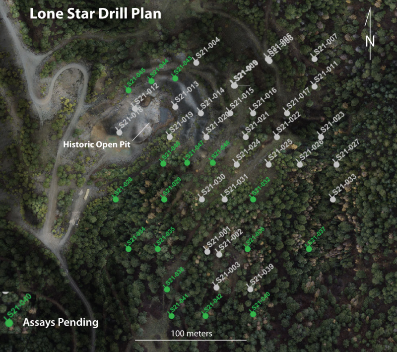
Lone Star Drill Plan Map
Click Image To View Full Size
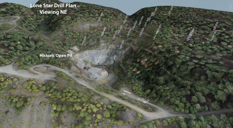
Lone Star Drill Plan Viewing NE
Significant Intercepts from the Lone Star drilling Program
|
Hole_ID
|
From
|
To
|
Interval
|
CuEq%
|
Cu %
|
Au g/t
|
Ag g/t
|
|
(m)
|
(m)
|
(m)
|
|
LS21-001
|
41.5
|
50.3
|
9.1
|
0.8
|
0.6
|
0.2
|
3.2
|
|
LS21-001
|
54.9
|
61.2
|
6.9
|
1.8
|
1.2
|
0.8
|
12.9
|
|
LS21-001
|
65.8
|
110
|
44.2
|
1.5
|
1.3
|
0.2
|
4.6
|
|
inc.
|
65.8
|
88.7
|
19.8
|
2.8
|
2.4
|
0.5
|
6.7
|
|
LS21-001
|
115.8
|
138.7
|
19.1
|
|
0.4
|
NSR
|
NSR
|
|
LS21-001
|
140.4
|
162.5
|
22.1
|
1.4
|
1.2
|
0.3
|
2.2
|
|
inc.
|
140.4
|
162.5
|
8.5
|
2.6
|
2.1
|
0.8
|
2.4
|
|
LS21-001
|
198.7
|
200.9
|
4.7
|
1.0
|
0.8
|
0.3
|
1
|
|
LS21-002
|
46.9
|
60.8
|
15.5
|
5.0
|
3.7
|
1.8
|
23
|
|
inc.
|
56.7
|
59.3
|
2.6
|
26.1
|
18.5
|
10.4
|
106
|
|
LS21-002
|
95.1
|
101.1
|
6
|
0.4
|
0.4
|
NSR
|
2.5
|
|
LS21-002
|
120.7
|
176.1
|
53.6
|
1.1
|
0.8
|
0.4
|
2
|
|
inc.
|
167.6
|
176.1
|
7.6
|
3.1
|
2.1
|
1.4
|
6.2
|
|
LS21-002
|
193.8
|
194.7
|
0.9
|
4.6
|
3.8
|
1.2
|
4
|
|
LS21-002
|
199.3
|
200.5
|
1.2
|
4.3
|
3
|
1.9
|
4
|
|
LS21-002
|
202
|
203.6
|
1.6
|
1.6
|
0.9
|
1
|
2
|
|
LS21-003
|
72.4
|
77.4
|
5
|
4.3
|
3.5
|
1.1
|
17.5
|
|
LS21-003
|
125.6
|
147.9
|
22.3
|
1.1
|
0.8
|
0.4
|
NSR
|
|
inc.
|
133.8
|
143.3
|
9.5
|
1.5
|
1.1
|
0.5
|
5.6
|
|
LS21-003
|
155.2
|
211
|
55.8
|
|
0.6
|
NSR
|
NSR
|
|
inc.
|
165.9
|
175.1
|
9.2
|
1.2
|
1
|
0.3
|
NSR
|
|
LS21-004
|
7
|
14.6
|
7.6
|
1.4
|
1.2
|
0.3
|
NSR
|
|
LS21-005
|
42.98
|
49.83
|
6.9
|
0.5
|
0.4
|
0.2
|
2.1
|
|
LS21-005
|
84.1
|
92.1
|
7.9
|
1.3
|
1.1
|
0.2
|
4.7
|
|
LS21-006
|
99.7
|
111.6
|
11.9
|
2.3
|
1
|
2
|
3.3
|
|
inc.
|
108.5
|
110.1
|
1.6
|
9.8
|
2.1
|
11.7
|
7
|
|
LS21-007
|
107.9
|
125.6
|
17.7
|
3.5
|
1.6
|
2.8
|
5.9
|
|
inc.
|
112.2
|
116.3
|
4.1
|
6.4
|
5.3
|
1.5
|
16.8
|
|
inc.
|
117.4
|
122.3
|
4.9
|
5.7
|
0.5
|
7.9
|
2.6
|
|
LS21-008
|
5.5
|
23.2
|
17.7
|
0.8
|
0.6
|
0.3
|
NSR
|
|
LS21-009
|
6.4
|
46
|
39.6
|
|
0.4
|
NSR
|
NSR
|
|
LS21-009
|
63.4
|
70.7
|
7.3
|
0.8
|
0.5
|
0.4
|
NSR
|
|
LS21-010
|
7.8
|
43.9
|
37.9
|
1.3
|
1
|
0.4
|
4.5
|
|
inc.
|
21
|
33.2
|
12.2
|
2.8
|
2
|
1.1
|
8.8
|
|
LS21-010
|
59.2
|
80.5
|
21.3
|
0.6
|
0.6
|
NSR
|
3.3
|
|
LS21-010
|
127.1
|
138.4
|
11.3
|
0.4
|
0.4
|
NSR
|
3.2
|
|
LS21-011
|
108.8
|
111.9
|
3.1
|
3.3
|
2.6
|
1
|
8.6
|
|
LS21-011
|
119.5
|
127.7
|
8.2
|
2.0
|
1.3
|
1
|
4.7
|
|
LS21-012
|
50.3
|
50.9
|
0.6
|
3.4
|
2.4
|
1.4
|
8
|
|
LS21-013
|
87.8
|
96
|
8.2
|
0.5
|
0.4
|
0.2
|
0.5
|
|
LS21-014
|
3.1
|
10.4
|
7.3
|
0.5
|
0.4
|
0.2
|
2.5
|
|
|
|
|
|
|
|
|
|
LS21-015
|
16.5
|
71.6
|
33.2
|
1.3
|
0.9
|
0.5
|
4.5
|
|
LS21-017
|
80.2
|
96.9
|
16.8
|
0.7
|
0.4
|
0.4
|
2.7
|
|
LS21-017
|
112.8
|
116.4
|
3.7
|
2.4
|
1.8
|
0.8
|
4.4
|
|
LS21-017
|
142.3
|
174.4
|
32
|
0.6
|
0.5
|
0.2
|
1.4
|
|
LS21-016
|
12.8
|
162.2
|
149.4
|
0.8
|
0.7
|
0.2
|
1.3
|
|
inc.
|
45.1
|
49.4
|
4.3
|
1.3
|
1.1
|
0.2
|
7.4
|
|
inc.
|
108.8
|
113.4
|
4.6
|
4.0
|
3.1
|
1.3
|
11.7
|
|
inc.
|
127.1
|
136.3
|
9.2
|
1.2
|
1
|
0.2
|
4.7
|
|
LS21-016
|
169.8
|
171.3
|
1.5
|
1.3
|
1.1
|
0.3
|
NSR
|
|
LS21-016
|
178.3
|
182.6
|
4.3
|
1.0
|
0.7
|
0.5
|
NSR
|
|
LS21-018
|
NSR
|
|
|
|
|
|
|
|
LS21-019
|
NSR
|
|
|
|
|
|
|
|
LS21-020
|
5.2
|
18.3
|
13.1
|
1.0
|
0.7
|
0.4
|
1.6
|
|
LS21-020
|
106.4
|
114
|
7.6
|
0.5
|
0.4
|
0.2
|
NSR
|
|
LS21-021
|
6.1
|
13.4
|
7.3
|
2.7
|
2.1
|
0.7
|
19.1
|
|
LS21-021
|
39
|
41.8
|
2.8
|
2.1
|
1.2
|
1.3
|
3.5
|
|
LS21-021
|
53.6
|
104.6
|
50.9
|
0.6
|
0.5
|
0.1
|
0.9
|
|
inc
|
53.6
|
71.9
|
18.3
|
0.8
|
0.7
|
0.1
|
1.7
|
|
LS21-021
|
120.7
|
150.3
|
29.6
|
0.9
|
0.8
|
0.1
|
3.7
|
|
LS21-022
|
41.2
|
76.2
|
35.1
|
1.0
|
0.8
|
0.3
|
5.6
|
|
inc
|
54.9
|
59.4
|
4.6
|
2.8
|
2.1
|
0.8
|
22.6
|
|
LS21-022
|
97.5
|
177.4
|
79.9
|
0.9
|
0.6
|
0.4
|
2.1
|
|
inc
|
151.2
|
158.8
|
7.6
|
3.2
|
1.3
|
2.8
|
11.8
|
|
LS21-022
|
181.7
|
193.1
|
11.4
|
0.7
|
0.5
|
0.3
|
1.9
|
|
LS21-023
|
138.7
|
163.1
|
24.4
|
0.8
|
0.6
|
0.3
|
2.7
|
|
LS21-023
|
179.8
|
198.1
|
18.3
|
0.8
|
0.5
|
0.4
|
0.9
|
|
LS21-024
|
50.3
|
75.6
|
25.3
|
0.8
|
0.7
|
0.2
|
1.4
|
|
LS21-024
|
110
|
178
|
64.3
|
0.5
|
0.4
|
0.1
|
2.8
|
|
LS21-025
|
140.5
|
198.7
|
58.2
|
0.8
|
0.6
|
0.3
|
2.2
|
|
inc.
|
174.4
|
181.1
|
5.2
|
2.2
|
1.6
|
0.9
|
2.4
|
|
LS21-026
|
82.6
|
84.7
|
2.1
|
0.8
|
0.7
|
0.2
|
1.3
|
|
LS21-026
|
116.1
|
121.9
|
5.8
|
0.6
|
0.5
|
0.1
|
2.2
|
|
LS21-026
|
139.9
|
184.1
|
44.2
|
0.5
|
0.4
|
0.2
|
1
|
|
LS21-027
|
111.6
|
122.2
|
10.7
|
3.1
|
2.4
|
1
|
5.5
|
|
inc.
|
117
|
122.2
|
5.2
|
5.4
|
4.1
|
1.9
|
9.5
|
|
LS21-027
|
151.8
|
200.6
|
48.8
|
0.6
|
0.5
|
0.2
|
0.9
|
|
LS21-027
|
215.8
|
237.1
|
21.3
|
0.9
|
0.4
|
0.7
|
NSR
|
|
inc.
|
226
|
232.3
|
6.3
|
2.3
|
0.8
|
2.3
|
0.8
|
|
LS21-027
|
111.6
|
122.2
|
10.7
|
3.1
|
2.4
|
1
|
5.5
|
|
inc.
|
117
|
122.2
|
5.2
|
5.4
|
4.1
|
1.9
|
9.5
|
|
|
|
|
|
|
|
|
|
LS21-030
|
25.6
|
56.1
|
30.5
|
1.2
|
0.9
|
0.5
|
2.2
|
|
inc.
|
40.5
|
53.6
|
13.1
|
2.0
|
1.5
|
0.7
|
2.7
|
|
LS21-031
|
32.9
|
40.5
|
7.6
|
1.1
|
0.6
|
0.7
|
2
|
|
LS21-031
|
51.5
|
55.2
|
3.7
|
1.0
|
0.9
|
0.2
|
1.1
|
|
LS21-031
|
57.3
|
63.4
|
6.1
|
1.6
|
1.4
|
0.3
|
1
|
|
LS21-031
|
157.6
|
181.4
|
23.8
|
1.0
|
0.7
|
0.4
|
1.2
|
|
inc.
|
159.1
|
170.1
|
11
|
1.4
|
1
|
0.6
|
1.7
|
|
LS21-033
|
NSR
|
|
|
|
|
|
|
|
LS21-039
|
134.1
|
217
|
70.7
|
1.0
|
0.7
|
0.4
|
2.8
|
|
inc.
|
148.7
|
152.1
|
3.4
|
14.3
|
4.3
|
14.9
|
29.5
|
|
LS21-039
|
230.7
|
240.2
|
9.5
|
1.9
|
1.3
|
0.9
|
4.3
|
About the Lone Star
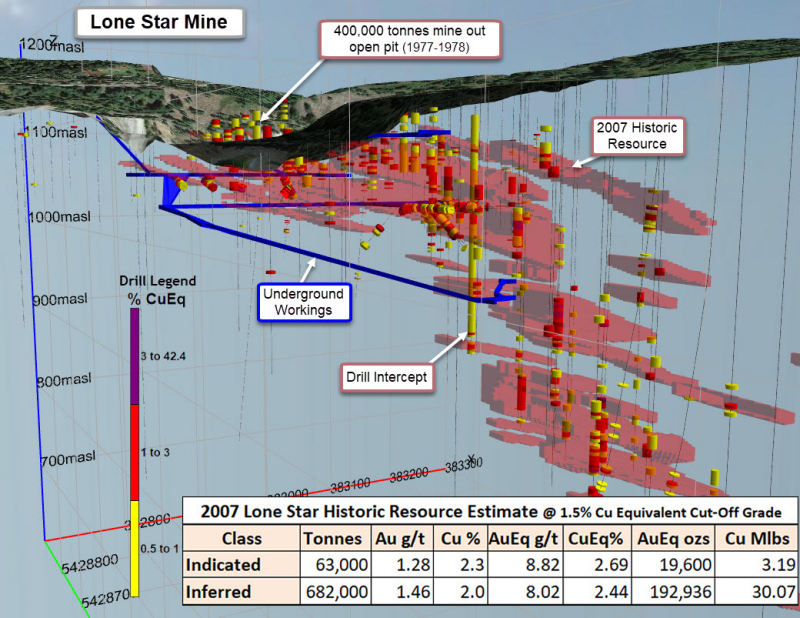
The Lone Star is a past producing open pit and underground mine with a 2007 historic resource as reported in a “Technical Report and Resource Estimate on the Lone Star Deposit, Ferry County Washington (September 23, 2007)” for Merit Mining Corp. and authored by P&E Mining Consultants Inc.
All work stopped on the Lone Star shortly after the publishing of the resource estimate due to the 2008 economic crisis. Belmont acquired the Lone Star property in July 2021 and is the first company to continue where Merit Mining left off, in advancing the Lone Star to production.
Click Image To View Full Size
(1) Mineral resources which are not mineral reserves do not have demonstrated economic viability.
(2) Gold equivalent (AuEq) grade was calculated utilizing a gold price of US$593/oz and copper price of US$2.84/lb., based on the 24 month (at July 31, 2007) trailing average of gold and copper prices, to obtain a conversion factor of % copper x 3.284 + gold g/t = Au Eq g/t. Metallurgical recoveries and smelting/refining costs were not factored into the gold equivalent calculation.
A qualified person has not done sufficient work to classify the historic estimate as current mineral resources or mineral reserves. As such the issuer, Belmont Resources, is not treating this historical estimate as current mineral resources or mineral reserves.
Belmont-Marquee JV
Marquee Resources (ASX:MQR) is earning the right to acquire an 80% interest in the Lone Star property (NR Nov. 4, 2021 – Belmont Signs Option/JV Agreements With Marquee Resources On Lone Star Property) by committing to the following:
About Belmont Resources
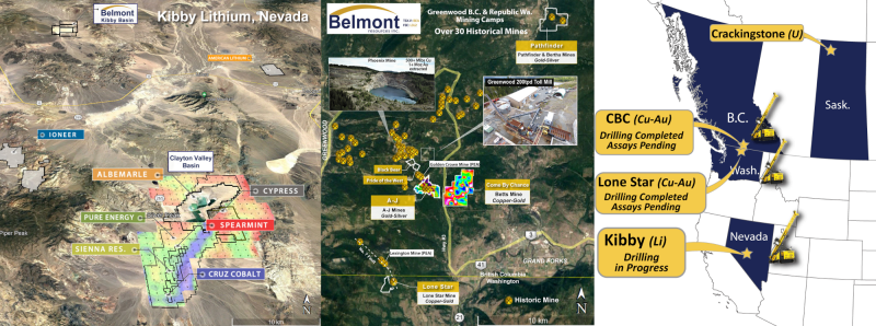
Belmont Resources has assembled a portfolio of highly prospective copper-gold-lithium & uranium projects located in British Columbia, Saskatchewan, Washington and Nevada States.
Its holdings include:
-
The Come By Chance (CBC), Athelstan-Jackpot (AJ) and Pathfinder situated in the prolific Greenwood mining camp in southern British Columbia.
-
The Crackingstone Uranium project in the uranium rich Athabaska Basin of northern Saskatchewan.
-
The Lone Star copper-gold mine in the mineral rich Republic mining camp of north central Washington State.
-
The Kibby Basin Lithium project located 60 kilometers north of the lithium rich Clayton Valley Basin.
Click Image To View Full Size
NI 43-101 Disclosure:
The technical information in this news release has been prepared in accordance with Canadian regulatory requirements as set out in National Instrument 43-101 and has been reviewed and approved by Laurence Sookochoff, P.Eng. Mr. Sookochoff is a Director of Belmont Resources Inc.
ON BEHALF OF THE BOARD OF DIRECTORS
“George Sookochoff”
George Sookochoff, CEO/President
Ph: 604-505-4061
Email: george@belmontresources.com
Website: www.BelmontResources.com
We seek safe harbor. Neither TSX Venture Exchange nor its Regulation Services Provider (as that term is defined in the policies of the TSX Venture Exchange) accepts responsibility for the adequacy or accuracy of this release. The TSX Venture Exchange has not approved nor disapproved of the information contained herein.
Copyright (c) 2022 TheNewswire - All rights reserved.