Montreal, Quebec--(Newsfile Corp. - January 21, 2021) - Beauce Gold Fields (TSXV: BGF) (Champs D'Or en Beauce), ("BGF"), is pleased to announce that it has acquired, from a Private Collector, a trove of never before published exploration data by the Beauce Placer Mining company that operated from 1957 to 1965 on the company's Beauce Gold property located in Saint-Simon-les-Mines, Quebec.
Patrick Levasseur, President and CEO of Beauce Gold Fields said, "This effectively triples the overburden drilling data that will give us an unprecedented overview of the placer channel." Mr. Levasseur added: "The data will have a profound impact in orientating our future rock drilling program to uncover the source of the gold placers."

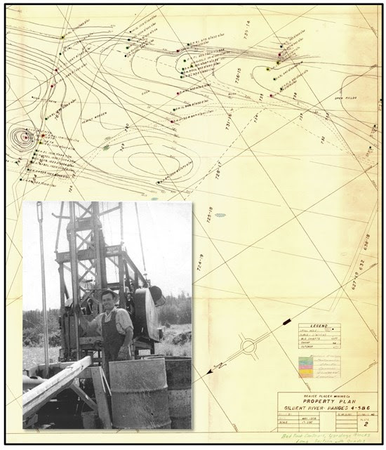
Figure 1: Drill Hole Map 1958, St-Gustave Road and Drill Operator
To view an enhanced version of Figure 1, please visit:
https://orders.newsfilecorp.com/files/6198/72519_6047194d34d5c989_001full.jpg
Active from 1957 to 1965, the Beauce Placer Company was the largest placer gold mining operation in eastern North America. Yet, there was very little documentation available of the work completed during that period. Historical reports found on the Government of Quebec's geology and mining data registry are but brief summaries and observations. Missing were drill hole logs and subsequent results, geophysics data, field surveys, compilation maps and for that matter, all aspects pertaining to the dredge mining operation itself. These have now been found.
According to the Collector, the documents originated from a field office the Beauce Placer Mining Company occupied in Beauceville, Quebec. The office was abandoned in the 1970s leaving behind filing cabinets full of documents. The documents were given to the Collector, a businessman from St-Simon-les-Mine. Being an avid antiques collector, he recognized the importance of preserving historical documentation pertaining to his town's heritage.
Document Highlights
- Total 344 drill logs from 7-inch wide overburden drill holes down to bedrock:
- Gilbert River (St-Simon-les-Mine) - 252 holes
- Famine River - 40 holes
- Chaudire River - 36 holes
- Riviere Du Loup - 12 holes
- Ruisseau Des Meule - 4 holes
- Geophysics
- Claims and property agreements
- Land surveys
- Documentation regarding the operation of the dragline and the Yuba dredge
- Daily back office operation
- Gold receipts from the mint
The exploration information will be integrated will all other historical data described in the company's Beauce July 4th 2018 43-101 report to create a comprehensive overview for analysis. For example, BGF reported 97 historical overburden drill holes (78 RC drill holes by Coniagas and Macamic plus 19 sonic drill holes by Geological Survey of Canada, and Uragold) along the St-Simon-les-Mine placer gold channel. By adding the 252 Beauce Placer Mining Company overburden drill holes, it will result in 349 holes of overburden drilling for an unprecedented overview of the placer channel. The company has commenced tabulation of the results and will compare these to other data collected to determine any priorities for bedrock source drilling.
Reference to the historical placer gold deposit does not comply with the CIM reporting standards National Instrument 43-101 for mineral resources or reserves and should not be relied upon. While the Company considers historical estimates to be relevant to investors as it may indicate the presence of mineralization, the Company is not treating these historical estimates as a current mineral resource.
About Beauce Gold Fields
Beauce Gold Fields is a gold exploration company focused on placer to hard rock exploration in the Beauce region of Southern Quebec. The Company's flagship property is the St-Simon-les-Mines Gold project site of Canada's first gold rush that pre-dates the Yukon Klondike. The Beauce region hosted some of the largest historical placer gold mines in Eastern North America that were active from 1860s to the 1960s It produced the largest gold nuggets in Canadian mining history (50oz to 71oz). The intent of Beauce Gold Fields is to trace the workings back to the bedrock source and uncover economic gold mineralization.
Comprising 152 contiguous claims and 7 real estate lots, the project area contains a six kilometer long placer channel consisting of an unconsolidated gold-bearing auriferous units of a lower saprolite and an upper brown diamictite. The Company has calculated a theoretical Gold Exploration Target for the entire historical placer channel ranges between 61,000 ounces (2,200,000 m3 @ 0.87g Au/m3) and 366,000 ounces*(2,200,000 m3 @ 5.22 g Au/m3).
*Source: Beauce July 4th 2018[43-101 Report.
The Company has identified a major Fault Line that coincides with an interpreted fault structure across the property. Evidence suggests the erosion of the Fault Line as a probable source of the historical placer gold channel, and has conducted bedrock sampling and geophysics outside the expression of the placer gold channel. The company will focus on the remote sensing surveys and compilation of the new information to prioritize its future programs.
Beauce Gold Fields website www.beaucegold.com