WILLOWBYDel Norte also includes the Willowby range. All but one small western section which use ot belong to - millrock which transacted this small claims to - tw oother junioors - seven devils + sojourn.
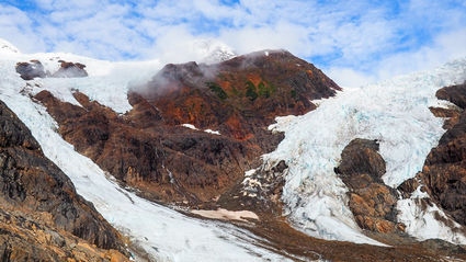
Why mention this ? Well, ot point out - Decade has majority of - willowby and to show this pic of the western side of,
willowby range... a great pic that shows what the eastern side looks like,.
Now - if the Horaito beside Del has a different geology matrix, and if these ranges are continous with same theme of, west side has the rhyolite and hazeltons and copper... and if mid way to easterly has the silver gold and some copper... then, this picof willowby's west side would explain the - rhyolites / quartz seen amongst the mafics with peachy color feldspar crystalines.

The article mentions something of, interest - grades from the main ( range ) zone.
This would most likely be in the - del norte ownership zone. ( hunch ) al because Decades
maps show Decade owning this section of Willowby.
What did the article say ? Willoughby, which lies 25 kilometers (16 miles) northeast of Stewart, has a long exploration history including two phases of drilling.
Highlights from drilling in 1989 and 1995 include 20.5 meters averaging 24.99 grams per metric ton gold and 184.22 g/t silver; and 2.9 meters of 383 g/t gold and 213.6 g/t silver.
The main zone at Willoughby. Historic drilling at this Golden Triangle property cut 20.55 meters averaging 25 grams per metric ton gold and 184 g/t silver. Seem's i have to patch... all the data together, in order to better understand each range
and their association to each other... ugh.
konkin, to midas, to willowby, to del norte.... The silver strike seems to be synomanous.
20m - 30+m - rich silver intercepts with gold + copper.
Midway and esterly, silver seems more perdominant.
Which is why i say... i think by the time the silver trend reaches del norte
i would make a bet and say... .from argo to a good 2km east of argo - silver could be still
present... just a hunch .
I have since opoened up - google maps + mapcarta... and google earth...
hate to say this.. but.. .what a shhh show...
the other day i could see amazing imnages on therse ranges - but now ?
They're all full of snow and cloud cover... ufb....
they must have swaps out the maps.
grrrrr.....same shhh whe ni was researching colombian ranges...
some days the maps were perfect - could see so close to the ground, almost explore
geology with the maps.. then, other days... nothing but blur and clouds...
Mill rock Seven devils article https://www.miningnewsnorth.com/story/2018/09/21/news/new-sojourn-in-bcs-golden-triangle/5356.html Original - Millrock - article - revealing drill intercepts on Willowby.
What's not known is... are these drill results from midway on Willowby or, only
western side ?
High grade gold-silver drill intercepts have been reported by prior explorers.
Historical intersections that have been reported include:
| | | | | | | | | | | |
| Hole # | | From (m) | | To (m) | | Core length (m) | | Gold (g/t) | | Silver (g/t) |
| | | | | | | | | | | |
| NZ89-061 | | 22.0 | | 42.5 | | 20.5 | | 25.0 | | 184.2 |
| | | | | | | | | | | |
| 95-532 | | 64.5 | | 77.5 | | 13.0 | | 13.3 | | 59.2 |
| including | | 72.5 | | 75.5 | | 3.0 | | 31.1 | | 124.5 |
| | | | | | | | | | | |
| 95-362 | | 88.4 | | 91.3 | | 2.9 | | 398.0 | | 199.4 |
| | | | | | | | | | | |
| 95-512 | | 47.8 | | 53.7 | | 5.9 | | 16.2 | | 50.2 |
| | | | | | | | | | | |
| 94-263 | | 75.6 | | 81.6 | | 6.0 | | 17.1 | | 664.3 |
| | | | | | | | | | | |
| 94-153 | | 66.0 | | 77.7 | | 11.7 | | 39.8 | | 102.4 |
LINK - https://ca.finance.yahoo.com/news/millrock-purchases-willoughby-gold-prospect-130000787.html CLAIMS MAP PICTURE - showing smaller willowby in blue - and larger section of
Willowby under the - Del Norte claims group.... personally i tihnk DEC should assign
the Willowby claims its rightful name.. .easier ot undersatand...
Del Norte in green... also convering majority of, Willowby.
Yeah... i'd say the silver runs more mid way and easterly along rthese ranges.
But, well before the sediments.
https://teuton.com/wp-content/uploads/2019/07/SVG-Fiji-updated_001.png Cheers....