MON GOLD - GEOPHYSICSTook a break from world news - lol Decided to see if i could find a geo map for - Mon Gold.
Why do so ? I wanted to see if there would be any sort of identifiable features on a geo map that would / could pinpoint another - pipe style vent deposits - other than the main - Mon.
Main goal ? Looking for a circular fashion pipe vent that would be pronounced around the core of the Mon mine.
Thing is.... When one looks at any geophysics map - one never really knows at what depth the geophysics have been captured - meaning - once the geophysics havde been inverted seeking visual depths of the geology - one could end up looking at extreme depths well
beyond 100m - 200m .
Mon's impressive historical gold was well under - 100m. Which makes this geo map sort of an anomaly - not knowing what dpeth the MT was aiming at or targeting.
Would be nice to see a surficial geophysics and then, take it at depth with inversion every 10m looking for those distinct indifferentations that might identify unusual deposit shapes that have that signature trait of - PIPES.
Just looking at the main entrance to the Mon Mine - it does have a striking feature -
= quartz and what looks like - feldspar silica seen in hues of - faded orange.
https://i.cbc.ca/1.5974195.1617327257!/fileImage/httpImage/image.jpg_gen/derivatives/original_780/mon-mine.jpg Could the feature of - broad swath quartz / silcasRIGHT AT SURFACE repeat elsewhere ?
Could this be that defining trait inwhich to find another potential pipe deppoist ?
Are there anymore ?
When one thinks of a presure pipe - vent.
If it manages to breakthrough at one - particular zone - i would figure - chances are -
the same presure belwo - might have erupted at a later date and created additional vents nearby - just theorizing.
Quartz and silicas under preasure ( long ago ) seeking less path of resistence- letting loose its pay load - kind of makes one wonder - culd it be that easy seeking out the same disposition as the Mon ?
Unfortunately - the Mon mine area is sparse of any colorations - whether omitted - or, just no identifiable mineral signature - my best guess is, the MT survey was inverted to a much further depth thus, the surface to 50m around the Mon mine is void of any signals.
Would be nice if Sixty - revisited thier MT survey and took it real slow - with inversions -
looking for that signature - imagery - that tipped off this area as being a hot spot for gold so
close to surface.
Was it the... pale colorations in which ( clays ) that devolped the greywackes along with argilites which comprise of carbons - are these two cofactors identifiable on a survey ?
Are they indifferent to that of a hot - pink zone or red ?
Again... could one take advantage of - fore knowing - what ot look for and would this aide in
zeroing in on another pipe vent deposit ?
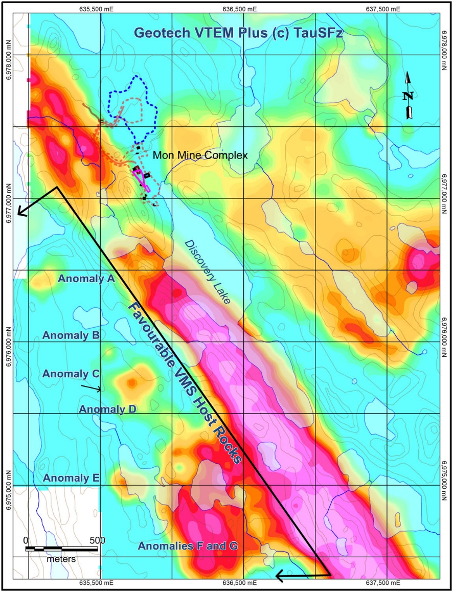
SURVEY MAP BELOW Anomalies - B,C,D don't even show red or pink.
Interesting.
VMS occurence ( runway ) is lit up all in pinks and skirted in reds.
And i would assume this VMS occurence is inline with the - MAFIC trends - ( east and west )
that actually run almost north and south.
https://www.juniorminingnetwork.com/images/news/newsfile/36283a153305819732118[1].jpg Over the years - reading other ( gov data )i've come across - clays can obscure MT read outs.
While carbons are naturally inherent to thatof - electrical absorbtions.
Could these sort of resistivities show on an MT survey inwhich to use as a vantage ?
Knowing what the Mon mine looks like at each geo depth - in my opinion - would tremendously help in perhaps spotting the next - pipe vent deposit.
Even as much as, seeking out a potentia llow lying volcano - which might have been overlooked as a current waterbody- present lake. Checking nearby lake geophysics - contour maps could provide alternative assistence.
Here's a good arial photo - https://cdn.investingnews.com/app/uploads/2019/10/Sixty-North-Gold-Map.png Lastly, It would be nice to see the overlay of the channel cuts map - atop this map -
https://www.juniorminingnetwork.com/images/news/newsfile/36336a153331519847692.jpg What woud it reveal if this channel map were overlayed atop the MT survey ?
Would it require altering the MT survey - guaging it without inversion - most definitely.
All because - the channel cut showings are al lwith - gold right at surface.
Yes... show me this kind of map - just what exactly are the geo colorations
over the channel cut locations ?
