IP Geophysical survey completed, and second environmental license granted
Vancouver, British Columbia–(Newsfile Corp. – August 3, 2021) – Altamira Gold Corp.’s (TSXV: ALTA) (FSE: T6UP) (OTC Pink: EQTRF), (“Altamira” or the “Company“) is pleased to provide an update regarding the upcoming maiden drill program at the Mutum target within the Apiacas project and to provide further information regarding the environmental licensing at the project which is located in northern Mato Grosso, Brazil.
Highlights:
- The initial 3,000m diamond drill program at Mutum is targeting part of the 4.4 km long high chargeability Induced Polarization (“IP”) anomaly identified during phase 1 of the IP ground geophysical survey. Phase 2 of the survey which extends the IP coverage 2.4km to the west has now been completed and the data is being processed
- Altamira has identified quartz-sericite-pyrite alteration associated with disseminated gold mineralization in an intrusive rock over 4 sq km on surface within the area of historic placer gold workings where surface channel sampling has been encouraging and has returned significant gold values including 12m @ 2.0 g/t gold
- The second environmental license at Mutum has been granted and is located to the west of the previously announced environmental permit and allows for the drilling of a large portion of the chargeability anomaly, and is valid until 06/04/2024
Michael Bennett, President and CEO of Altamira Gold commented “The commencement of the initial drilling program at the Mutum target at Apiacas is truly exciting and is the culmination of several years of effort. During the last few months, Altamira has identified a geophysical chargeability anomaly that is now in excess of 4km in east-west extent and is coincident with an area of historic workings which produced 1Moz of gold as well as widespread quartz-sericite-pyrite alteration and disseminated gold mineralization. The target is simply enormous, and we look forward to the results of the initial drill program.”
The Mutum target is part of the Apiacas Project area and is located 50 km west of Altamira’s Cajueiro gold project which hosts 43-101 compliant indicated resources of 5.66Mt @ 1.02 g/t gold for a total of 185,000oz and inferred resources of 12.66Mt @ 1.26 g/t gold for a total of 515,000oz. An estimated 1Moz of colluvial gold was historically recovered from the Mutum target, suggestive of the presence of a significant underlying hard-rock deposit.
In 2019, geological mapping outlined an area of pervasive disseminated-style gold mineralization over at least 4 sq km at Mutum. A total of 93 surface rock samples of disseminated and altered rocks collected on surface over this area returned gold values of up to 406.6 g/t gold (see news release dated September 11, 2019). Recent exploration has also identified four high-grade vein structures with channel samples returning values up to 3m @ 10.39 g/t gold. Silver assays have also returned high grade values up to 871 g/t silver (see news release dated March 8, 2021).
IP Survey
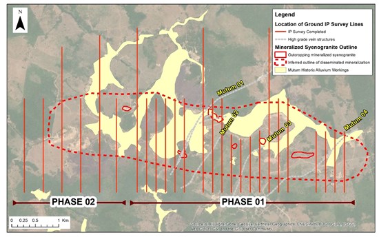
The initial phases 1 and 2 of the IP survey have now been completed in the Mutum target area and the geophysical team has been demobilised. The results of phase 2 are being processed over the western extension of the target area. A total of 26 N-S oriented lines were opened and surveyed covering a total length of 53 km (see Figure 1).

Figure 1 Completed IP survey lines at the Mutum target covering an east-west extension of 6.6 kms.
Note distribution of historic colluvial gold workings in yellow
To view an enhanced version of Figure 1, please visit:
https://orders.newsfilecorp.com/files/4500/91929_403017b564624ba9_001full.jpg
Drill Program
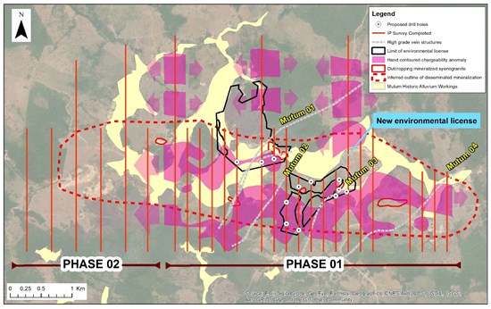
The initial 3,000 metre diamond drill program will investigate the depth continuity of the surface gold mineralization mapped and sampled within the syenogranite intrusive rock between lines 3 and 8 where three separate channel samples collected from the outcropping mineralized intrusive returned values of 2.0 g/t gold over 12 metres, 0.9 g/t gold over 6 metres and 0.41g/t gold over 12 metres in the northern part of lines 3, 4 and 5 and will investigate part of the high chargeability anomaly which lies directly beneath areas of historic alluvial and colluvial workings on the southern extensions of the lines between lines 3 to 8. Drill holes will be targeted to an initial depth of 150 metres and 8 initial holes have been sited within the area which has received recent environmental permission for both trenching and drilling (see Figure 2). Further holes will be sited once geological and assay data is on hand from the initial holes.
Drilling is expected to continue until October and samples will be submitted to the SGS laboratory in Belo Horizonte where the turn around time is expected to be between 4-6 weeks.

Figure 2 Map showing proposed initial drill holes and new area with environmental license.
To view an enhanced version of Figure 2, please visit:
https://orders.newsfilecorp.com/files/4500/91929_403017b564624ba9_002full.jpg
Granting of Second Environmental License at Mutum
The environmental department of the state of Mato Grosso, SEMA/MT has approved a second environmental permit LOP No 324020/2021 covering part of the central area of the Mutum target which allows Altamira to trench and drill under both the chargeability anomaly and areas with mineralized syenogranite intrusive rock which has been mapped and sampled on surface. The permit covers part of the ANM 846.947/2018 exploration permit and is valid until 06/04/2024. This is a significant milestone as it expands the area within the Mutum target which can now be drill tested in order to prove the potential of the target.
Qualified Person
Guillermo Hughes, FAIG and M AusIMM., a consultant to the Company as well as a Qualified Person as defined by National Instrument 43-101, supervised the preparation of the technical information in this news release.
Neither the TSX Venture Exchange nor its Regulation Services Provider (as that term is defined in the policies of the TSX Venture Exchange) accepts responsibility for the adequacy or accuracy of this release.
About Altamira Gold Corp.
The Company is focused on the exploration and development of gold projects within western central Brazil. The Company holds 8 projects comprising approximately 190,000 hectares, within the prolific Juruena gold belt which historically produced an estimated 7 to 10Moz of placer gold. The Company’s advanced Cajueiro project has NI 43-101 resources of 5.66Mt @ 1.02 g/t gold for a total of 185,000 oz in the Indicated Resource category and 12.66Mt @ 1.26 g/t gold for a total of 515,000 oz in the Inferred Resource category.
On Behalf of the Board of Directors,
ALTAMIRA GOLD CORP.
“Michael Bennett”
Michael Bennett
President & CEO
Tel: 604.676.5660
Toll-Free:1-833-606-6271
info@altamiragold.com
www.altamiragold.com
Forward-Looking Statements
Statements in this document which are not purely historical are forward-looking statements, including any statements regarding beliefs, plans, expectations or intentions regarding the future. It is important to note that actual outcomes and the Company’s actual results could differ materially from those in such forward-looking statements. Except as required by law, we do not undertake to update these forward-looking statements.