news
Sokoman and Benton Expand the Kraken Lithium Pegmatite Swarm in Newfoundland
2021-10-14 07:12 ET - News Release
- Dyke system expanded: 2.2 km-long by 0.85 km-wide
- Fine-grained spodumene identified in several new areas
- Dyke system is wide open for expansion


Company Website: https://sokomanmineralscorp.com
Company Website: https://www.bentonresources.ca
ST. JOHN’S, Newfoundland and Labrador -- (Business Wire)
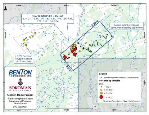
Sokoman Minerals Corp. (“Sokoman”) (TSXV: SIC) (OTCQB: SICNF) and Benton Resources Inc. (“Benton”) (TSXV: BEX) (jointly “the Alliance”) are pleased to announce that prospecting has expanded the area containing lithium-bearing pegmatite dykes, now known as “The Kraken Pegmatite Swarm”, to an area measuring approximately 2.2 km-long by 0.85 km-wide. In the past two weeks, the Alliance has focused their prospecting to the east of the original discovery and now have identified multiple areas of spodumene-bearing pegmatites dykes ranging from 0.5 m to 10.0 m in thickness from possible stacked swarms striking approximately 50 degrees and dipping 45-65 degrees east with unknown strike length. A total of 55 samples were collected over the eastern-half of the swarm area and assay results are expected within the next few weeks. All samples were submitted to Actlabs in Ancaster, Ontario for analysis by Sodium Peroxide Fusion ICPOES + ICPMS.
This press release features multimedia. View the full release here: https://www.businesswire.com/news/home/20211014005177/en/

Golden Hope Project: Kracken Pegmatite Swarm Sampling and Proposed Drone Survey
The Alliance also received further assays from a second phase of sampling collected from a till covered area, west of the original discovery, with samples of sub-crops and large local boulders returning anomalous results of rubidium, tantalum and lithium. One sample of a large, angular, purple pegmatite boulder located 600 m west of the original lithium zone graded 1.04% Li2O. The sampling has demonstrated that the dyke system contains economic grades of lithium, is widespread, and open along strike.
The Alliance is planning detailed geological mapping and a high-resolution drone survey that will include imagery, lidar and magnetic datasets to assist in the mapping and targeting the dyke system for drilling which will commence shortly. The companies have already completed a 5,709 line-km Heliborne High-Resolution Aeromagnetic & Matrix Digital VLF-EM Survey flown by Terraquest Ltd. with the final data currently being processed. The survey will provide the structural / lithological setting and help identify gold-bearing structure extensions, as well as any unrecognized structures including those potentially related to the lithium-bearing pegmatites.