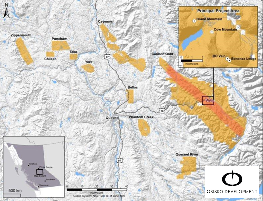
BGM - ( OSISKO'S ) CARIBOO + HAWKEYE'S KEITHLEY CREEK Here's a map of Osisko's - Barkerville gold claims seen in gold coloration.
Take note of the location of the barker gold mine - near Wells B.C.
It's in a basin - and if one analyses the picture -
one will see the Well's town is located in a - depression landscape - lower elevation.
Not hard to think - placer gold deposit - caused by, larger watershed stewm.
Most of - BGM's former cores were all shallow intercepts - in what appears as a conglomerate mudstone remix - rewelded. Now when i see inside the underground mine -
i tend ot dismiss those pics and revert back ot the shallow intercepts and with two fingers pointed at the shallow naturte of the gold - deposit,
COW MOUNTAIN https://www.northernminer.com/wp-content/uploads/2016/04/Barkerville-260x146.jpg
Here's a superb rendition of the gold mineralization - strike path crossing ranges. https://www.juniorminingnetwork.com/images/cache/35930bf90ecf9b3359062386803efe77-950px.webp
As one can see the ( square ) inset box locating the twon of Wells.
I would have ot disagree with the ( red stripe ) expected mineral path and simply
say the gold is attributed to a watershed system that was far largert - clearly seen
as a former lake where Wells town sits and movign north easterly where appears a
potential wide river systgem came rushing in to deposit the gold near Wells.
Why mention all this ?
Simply put - could Cariboo lake have similar attrributes as Wells ?
And if so, how would and where would the gild similar ot Wells ?
Most logical place would be at the forks north end of Cariboo lake/river
Hawkeyes - 2 Aces and Cariboo claims.
And, lowewr end of Cariboo river system as it approaches the town of, Lively,
Which just so happens to be where - Karus's small extension claims are.
BUT... there still appears to be a section of land where osisko nor karus has scooped.
From the south end of Cariboo lake,just above karus's claims and the delta kick put -
So, i would say, if there's a potential limited amount of veining or volcanics,
Then, search out the top ranges and bottom of ranges - looking for - those distinct watershed paths that may have brought in awack of placer gold and deposited.
Even if at a top of a range and one sees - placer conglomerages rocks - such just suggests, the range lifted a valley up - at a later date. I'd be with two eyes wide open looking for not only
volcanics andveining but also - placer deppisits that parked gold at resistnet points.
Hopping to emulate the Barker gold discovery.
Keithly creek's til lwashing down into the Cariboo lake would be a good snag, before osisko and karus jumps on it. With a click of a mouse - one can stake claims.
What say ye, Hawkeye ?
Tease.
In all seriousness - the delta could have deposited gold from the upper keithley ranges and also at same time captured gold from the Cariboo lake river system acting as a choke point.
