Join today and have your say! It’s FREE!

Become a member today, It's free!

We will not release or resell your information to third parties without your permission.
Please Try Again
{{ error }}
By providing my email, I consent to receiving investment related electronic messages from Stockhouse.

or

Sign In

Please Try Again
{{ error }}
Password Hint : {{passwordHint}}
Forgot Password?

or

Please Try Again {{ error }}

Send my password

SUCCESS
An email was sent with password retrieval instructions. Please go to the link in the email message to retrieve your password.

Become a member today, It's free!

We will not release or resell your information to third parties without your permission.
Quote  |  Bullboard  |  News  |  Opinion  |  Profile  |  Peers  |  Filings  |  Financials  |  Options  |  Price History  |  Ratios  |  Ownership  |  Insiders  |  Valuation

Hawkeye Gold and Diamond Inc V.HAWK

Alternate Symbol(s):  HWKDF

Hawkeye Gold & Diamond Inc. is a junior mineral exploration and development company. The Company is engaged in the exploration for and the development of natural resources in Canada. Its projects include Bonanza, 2-Aces, Keithley Creek, Cariboo Valley, Seller Creek, Swift River, Bonanza Lake and Cariboo Lake. The Company owns over four 2% royalty interests which are subject to buy-down provisions on the Railway, McBride, Boomerang and Todagin properties located in the Golden Triangle of northwest British Colum (BC). The Bonanza property is located on the northern end of Vancouver Island, British Columbia, Canada, and is situated approximately 110 kilometers (km) northwest of Campbell River and 69 km southeast of Port Hardy. The 2-Aces property is situated approximately 32 km southeast of the Town of Barkerville, British Columbia (B.C.), Canada. It owns an interest in the 3,599-hectare Keithley Creek property situated approximately 30 km south of the Town of Barkerville, B.C., Canada.


TSXV:HAWK - Post by User

Post by Wangotango67on Nov 07, 2021 1:43pm
155 Views
Post# 34097558

MCBRIDE + RAILWAY

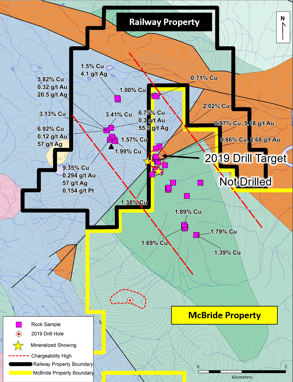
MCBRIDE + RAILWAYHere's a Hawk map depicting where a 2019 drill program tapped one hole.

Where should they have drilled ?
Exactly on the Railway proerty where they sampled very good copper + silver findings.
https://hawkeyegold.com/wp-content/uploads/2021/06/McBride-and-Railway-geology-2-June-16-2021.png


Here's a mapcarta map pinpointing Tahtue Mountain.
Reference the mineral samplings map and then compare to the Mapcarta map.

There's distinct vein like outcrops that exude a grey ore.
A good 3km east to west " grey ore  rock showing "
spans the area where it says - not drilled.


The 2019 drill hit an area of totally different geology.
Appears as if it might be on another range unassociated to the core copper silver findings.

i would think... a drill program of 500m would do wonders.
Tapping 10 holes 50m each along this 3km exposed strike might be the -  fix.
That 2019 loner hole is a real head scratcher - given - all the best results of samplings is where the drills should've hit.

Heck... even a winkie drill running 25m each hole - cut the costs - would reveal lots.
Given the outcrops are right at surface. 

Thosr are some nice copper + silver samples.
I wonder if there's zinc ?
I did notice platinum was also in the mix.
Surprise, surprise.

I also reccommend Hawk to test their 2019 dril lcores with their - XRF.
As one can read, in prior posts.... copper can take on all sorts of bonds.
In this McBride area. other miners have 2 kinds of copper.
Just saying...

I also think.. the 4-5 finger arms off to right side of map, of Mt Thateu looks similar to the
ores in the 3km strike zone. Appears loose tills are easily accessible to test.

https://mapcarta.com/24672178

From the word - Mount Thateu
is where the snaking grey outcrop is located.
An unusual - oviod - is positioned almost center of this 3km grey strike.
Interesting it is... water pocket ? volcanic related ?


Cheers...


<< Previous
Bullboard Posts
Next >>