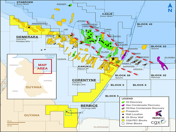
Map Placing Stabroek right on top of CorentyneWhen you look at this map, it shows the red outline of what is assumed to be the Corridor that contains the primo geology analogous to the Exxon Group's 30+ successful wells. As you can clearly see almost all of the Northern Corentyne and both Wei (The Black Star) and Kawa are within that corridor and Exxon's sucussful Pluma well is almost on top of the border with Corentyne. Surely the oil doesn't just suddenly stop at the Corentyne border with Stabroek
Since offshore Guyana has someone become a modern day global black gold rush, I would think multiple bidders are interested in this block that is practically turnkey. That is years, if not a decade ahead of someone leasing one of Guyana's new and raw unknown offshore blocks. where none, are nearly as close to the SE area of Stabroek as Corentyne, the area where Exxon has found most of their12 billion+ barrels of oil with surely more to come.
I would think any deal delay would be due to weighing multiple offers and surely not no offers. In addition, some company(s) such as CNOOC might want to just buy the entire company (FEC) and that would also complicate matters even more due to weighing bids and add time in getting a very complicated deal done.
I highly doubt they announce any deal next Wed, but I would not be surprised if they increase the dividend since over half goes to the two Venture Capitalists owning/completely controlling over 50% of the company.
just my deflated one cent worth.
