RE:RE:Way to early Price Predictions - for August I never give out dollar estimates on any share as the Drill bit always determines the share direction.
IMO, UP-TO this time fram to-day...BAY-AWM from a mining Exploration perspective, won;T see year end with-out a offer in hand,
BAY, current 200,000 tn cu, @ 1.2 % with a cut -off grade at .28 % WILL be up-graded from reserve catergory up-to In-dicated catergory on 43-101. The drilling-infilling this season well see an-other 200,000 tns resrve added to 43-101 which will also show a PEA mining start showing all enginerred ligistics,.
The Tempest Gosslan has 30 % cu spread over 4k again at surface whigh agian will see deep drill under Gosslan..
PS,.Schcor, less set the dialogue straight here as we all have opinions,
The 4 deep holes were again perimeter holes boxing in a large deep foot print,. The 4 holes were snipper holes in perticular looking for the , PS. here cut and paste says it all,..
Self-explanitory.“This is a phenomenal success rate for testing blind targets that once again points to the immense potential for new discoveries at Storm” stated Thomas Ullrich, CEO of Aston Bay. “The evidence mounts for a regional-scale copper system as predicted by our geological model. We are hitting copper in the same stratigraphic horizon in every widely spaced drill hole.
“The ground gravity geophysical survey conducted by Scott Smith’s team at Initial Exploration this spring has proven its mettle as a robust and effective method for delineating sulfide mineralization in the subsurface at Storm. A critical upshot of this is that the new gravity data indicates that the large gravity anomalies from the historic surveys, previously thought to be too deep to be of interest, are potentially well within reach. We are pleased that American West is advancing the development potential of the high-grade, near-surface copper mineralization at Storm, and extremely excited for the advances made in the game-changing discoveries of the sediment hosted copper mineralization we predicted lurked in the subsurface.”

Figure 1: Breccia chalcocite (dark grey) and pyrite (yellow, brassy) in drill hole ST23-04 from approximately 349.5m downhole.

Figure 2: Plan view of the Storm area showing the gravity data interpretation, known copper deposit footprints (yellow),
major faults, and diamond drill hole locations as discussed in this report.
DIAMOND DRILLING SUCCESS SUPPORTS LARGE-SCALE COPPER SYSTEM
Diamond drill hole ST23-04 has been completed in an untested area of the Storm Project and over 2km west of the recent Thunder zone discovery (August 8, 2023 Aston Bay news release).
The drill hole is the fourth hole to be completed in the current diamond drill program and was designed to test a strong gravity anomaly and to also intersect one of the main interpreted structures in the area, the Southern Graben Fault. Both targets were successfully tested and provide further evidence of a regional scale copper sulfide system within the Storm Project area.
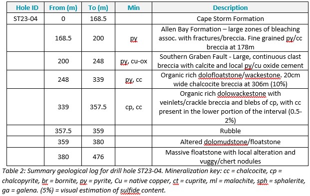
ST23-04 intersected two zones of visual copper mineralization. The first, a wide sulfide-bearing fault zone, is interpreted to be the Southern Graben Fault. Though only minor copper is present within the fault zone, the results confirm the presence of copper mineralization and fluid movement within this regionally important and laterally extensive structure. Significantly, the drill hole intersected the fault zone over 700m along strike from the near-surface high-grade copper mineralization at the 3500N Zone (where intersections include 35.4m (core length) @ 1.73% Cu in ST99-43). This highlights the structure as an important plumbing system for copper mineralization and points to the potential relationship between the lower sediment-hosted style and upper, near-surface copper mineralization.
The second zone of visual sulfide copper mineralization intersected within ST23-04 is an 18.5m thick zone containing chalcopyrite and chalcocite which is interpreted to correlate with the same distinctive sediment-hosted mineralized horizon as encountered within diamond drill holes ST22-10, ST23-01, ST23-02 and ST23-03 (Figures 2 & 3).
Significantly, drill hole ST23-04 is located immediately north of a large, untested 880m x 470m FLEM anomaly that was defined during the 2022 field season (Figure 3). Similar conductive anomalies elsewhere at Storm have been confirmed by drilling to contain sulfide mineralization.
The repeated intersections of copper sulfide within this predictable stratigraphic horizon, and ongoing success of the gravity data as a reliable targeting tool, has enormous implications for the potential for further discoveries within the Storm area.
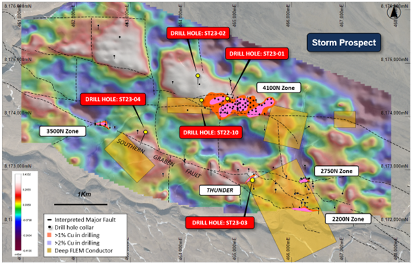
Figure 3: Total bouguer gravity image of the Storm area, fault architecture, drill hole and deep FLEM conductor locations overlaying aerial photography.

DRILL HOLE ST23-04 DETAILS
Diamond drill hole ST23-04 was drilled to a downhole depth of 476m and has intersected a large copper-enriched breccia/fault zone and a thick interval of visual sediment hosted copper sulfide mineralization. The drill hole was designed to test a gravity anomaly south of the Southern Graben Fault, as well as test the large fault system itself (Figures 2 & 3).
The upper zone of pyrite and copper mineralization is hosted within a 48m thick, calcite-rich fault zone that is interpreted to be the Southern Graben Fault (Figure 7). The fault zone is comprised of a matrix-supported clast breccia with the matrix locally replaced with calcite cement and locally milled and silty dolomudstone (Figure 4). The fault zone contained a large, ice-filled cavity and local occurrences of pyrite cement with anomalous copper (confirmed with portable XRF).
Breccia and fracture-fill-related copper is the likely source of copper anomalism within the fault zone. The presence of copper within this major structure is highly significant and confirms the ability of the structure to act as a source of plumbing for copper-rich fluids. This supports the potential for further high-grade copper mineralization similar to the 2750N, 2200N, 3500N and Thunder Zones along this extensive regional structure.
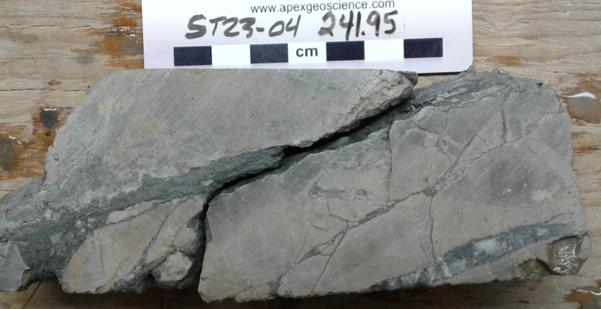
Figure 4: Silt and calcite (darker grey and white respectively) fracture fill within the Southern Graben Fault Zone from drill hole ST23-04
(approximately 241.95m downhole). The fracture matrix is anomalous in copper and likely contains copper oxides after chalcocite (copper sulfide).
The lower zone of mineralization was intersected at 339m downhole and is interpreted to correlate with the sediment-hosted copper mineralization intersected in drill holes ST22-10, ST23-01, ST23-02 and ST23-03 (Figure 7).
The broad mineralized interval consists mostly of chalcopyrite blebs, veinlets, and crackle breccia (Figure 5), with chalcocite present in the lower part of the sequence (Figure 1 & 6). Like previous drill holes, the copper sulfides are hosted within a sequence of organic-rich dolostones. This association confirms the extensive and predictable nature of this prospective stratigraphic horizon.
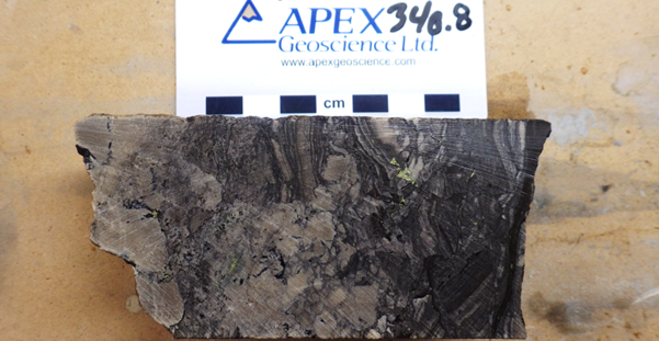
Figure 5: Blebby chalcopyrite (yellow brassy) and organic rich breccia in drill hole ST23-04 from approximately 340.8m downhole.
The strong presence of chalcopyrite in the lower copper intersection of ST23-04 suggests that the drill hole has potentially intersected the edge of the copper sulfide system: the mineralization at Storm shows a distinct zonation with a large copper-rich core (chalcocite, bornite and covellite) that gives way laterally and vertically to thinner peripheral zones of copper-iron (chalcopyrite, dominant in this intersection), iron (pyrite), zinc (sphalerite) and minor lead (galena). This spatial association of peripheral-style chalcopyrite mineralization is supported by the location of the intersection at the margin of the targeted gravity anomaly.
Density measurements (specific gravity) conducted on the drill core have shown the sulfide-mineralized intervals to be the only plausible source for the modeled gravity anomalies. The recently completed high-resolution ground gravity surveys are clearly effective at identifying hidden sulfide mineralization within this stratigraphic setting. This provides a highly effective targeting tool and suggests that all of the large gravity anomalies previously identified in the 2017 airborne gravity survey are prospective copper targets.
Furthermore, the three-dimensional modeling of the new ground gravity data indicates that the extensive historic airborne gravity anomalies, which previously modeled at a depth exceeding 1km, are likely much shallower at approximately 300m depth, well within reach of the diamond drill. As a result, the large fault-bounded gravity anomalies to the east and southeast of Storm are now high-priority targets for the 2024 geophysical and drilling programs.
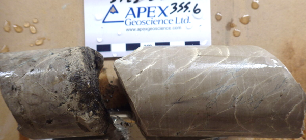
Figure 6: Breccia and veinlets of chalcocite (dark grey) in drill hole ST23-04 from approximately 355.6m downhole.
Visual estimates of mineral abundance should never be considered a proxy or substitute for laboratory analyses where concentrations or grades are the factor of principal economic interest. Laboratory assays are required to determine the presence and grade of any contained mineralization within the reported visual intersections of copper sulfides. Portable XRF is used as an aid in the determination of mineral type and abundance during the geological logging process.
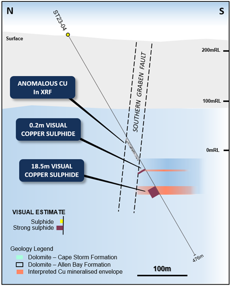
Figure 7: N – S geological section through drill hole ST23-04.
PLANNED PROGRAM
- The drilling is continuing to test key geophysical and geological copper targets in the Storm area.
- Laboratory assays for the RC and diamond drilling are pending and are expected within the coming weeks.
- The ore sorting, beneficiation and process optimization continues on a range of ore types.
- An environmental baseline survey is underway.
About the Storm Copper and Seal Zinc-Silver Projects, Nunavut
The Nunavut property consists of 173 contiguous mining claims covering an area of approximately 219,257 hectares on Somerset Island, Nunavut, Canada. The Storm Project comprises both the Storm Copper Project, a high-grade sediment-hosted copper discovery (intersections including 110m* @ 2.45% Cu from surface and 56.3m* @ 3.07% Cu from 12.2m) as well as the Seal Zinc Deposit (intersections including 14.4m* @ 10.58% Zn, 28.7g/t Ag from 51.8m and 22.3m* @ 23% Zn, 5.1g/t Ag from 101.5m). Additionally, there are numerous underexplored and undrilled targets within the 120-kilometre strike length of the mineralized trend, including the Tornado copper prospect where 10 grab samples yielded >1% Cu up to 32% Cu in gossans.
Storm Discovery and Historical Work
High-grade copper mineralization was discovered at Storm in the mid-1990s by Cominco geologists conducting regional zinc exploration around their then-producing Polaris lead-zinc mine. A massive chalcocite boulder found in a tributary of the Aston River in 1996 was traced to impressive surface exposures of broken chalcocite mineralization for hundreds of metres of surface strike length at what became named the 2750N, 2200N, and 3500N Zones. Subsequent seasons of prospecting, geophysics and over 9,000 m of drilling into the early 2000s confirmed a significant amount of copper mineralization below the surface exposures as well as making the blind discovery of the 4100N Zone, a large area of copper mineralization with no surface exposure.
Following the merger of Cominco with Teck in 2001 and the closure of the Polaris Mine, the Storm claims were allowed to lapse in 2007. Commander Resources staked the property in 2008 and flew a helicopter-borne VTEM survey in 2011 but conducted no additional drilling. Aston Bay subsequently entered into an earn-in agreement with Commander and consolidated 100% ownership in 2015. Commander retains a 0.875% Gross Overriding Royalty in the area of the original Storm claims.
In 2016 Aston Bay entered into an earn-in agreement with BHP, who conducted a 2,000-station soil sampling program and drilled 1,951m of core in 12 diamond drill holes, yielding up to 16m* @ 3.1% Cu. BHP exited the agreement in 2017. Aston Bay conducted a property-wide airborne gravity gradiometry survey in 2017 and drilled 2,913m in nine core holes in the Storm area in 2018 yielding a best intercept of 1.5m* @ 4.39% Cu and 20.5m* @ 0.56% Cu.