Diamond drilling intersects new zones of copper at depth as the deep search EM survey identifies a 1,300m x 500m anomaly for drill testing
HIGHLIGHTS
- 100% hit rate continues for the deep diamond drilling with thick intervals of visual copper mineralization intersected at depth below the known near-surface copper deposits
- The drilling confirms the large lateral extent of the Storm copper system at depth – now intersected over 10 square kilometres – and highlights the potential of Storm to host large-scale stratigraphic and structurally hosted high-grade copper deposits similar to those in the Central African Copperbelt
- Drill hole ST24-01 has intersected a combined total of 21.3 metres (“m”) of visual copper mineralization, which includes:
- 6.37m of visual copper sulfide from 293.7m downhole, and
- 2.43m of abundant visual copper sulfide from 302m downhole
- 12.5m of visual copper sulfide from 311m downhole, including
- 4.6m of abundant visual native copper and copper sulfides from 315.4m downhole
- Drill hole ST24-02 has intersected a combined total of 99.2m of visual copper sulfide, which includes highlights:
- 1.1m of abundant visual copper sulfide from 195.5m downhole, and
- 1.3m of abundant visual copper sulfide from 204m downhole, and
- 17.1m of moderate to abundant visual copper sulfide from 404.3m downhole
- The deep search phase of the Moving Loop Electromagnetic (MLEM) survey has defined a 1,300m x 500m anomaly at depth below the Cirrus Deposit and The Gap Prospect, with target drilling now underway
Visual estimates of mineral abundance should never be considered a proxy or substitute for laboratory analyses where concentrations or grades are the factor of principal economic interest. Laboratory assays are required to determine the presence and grade of any contained mineralization within the reported visual intersections of copper sulfides. Portable XRF is used as an aid in the determination of mineral type and abundance during the geological logging process.
TORONTO, Ontario, August 22, 2024 – Aston Bay Holdings Ltd. (TSXV: BAY) (OTCQB: ATBHF) ("Aston Bay" or the "Company”) is pleased to provide an update on drilling activities at the Storm Copper Project (“Storm” or the “Project”) on Somerset Island, Nunavut. The exploration program is being conducted by American West Metals Limited (“American West”), who is the operator of the Project. Aston Bay and American West have formed a 20/80 unincorporated joint venture in respect of the Storm Project property, with Aston Bay maintaining a free carried interest until a decision to mine upon completion of a bankable feasibility study.
Thomas Ullrich, Chief Executive Officer of Aston Bay, commented:
“The first two deep diamond drill holes of this season have hit an impressive amount of visual copper mineralization of the same style as we see in the high-grade near-surface deposits. When added to the five deep holes drilled over the 2022 and 2023 seasons in a 10 square kilometre area, all of which hit copper and associated sulfide mineralization at depth, the “Storm Deeps” drilling is developing into a compelling exploration story.
“The two new holes were drilled on structural and stratigraphic targets before the completion of the new deep-looking geophysical surveys that have yielded large, strong anomalies at the same stratigraphic level as the copper intercepts in the deep holes. These electromagnetic surveys have proven very successful in targeting copper mineralization at Storm, and I expect the upcoming deep holes, including one currently underway, will benefit from improved targeting of potentially higher-grade and larger zones of copper mineralization. I am eager to see what the drill rig reveals in the coming weeks.”
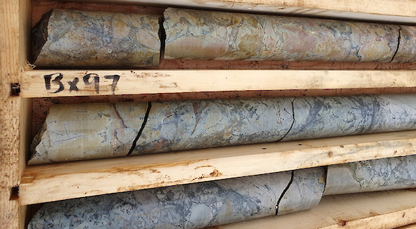
Figure 1: Drill core from ST24-01 from approximately 315.4 – 318m downhole. Dense veins and breccia of visible chalcocite (copper sulfide) can be seen as dark sooty grey, within light grey/tawny dolomite host rocks. This interval also contains blebs of native copper (metallic mineral, top right).
DEEP COPPER SYSTEM EXPANDING
Diamond drill holes ST24-01 and ST24-02 have been completed at the Storm Project with both drill holes building on the success of prior deep drilling programs by intersecting thick intervals of visual copper mineralization containing thinner subintervals of very abundant visual copper.
The drill holes were designed to test key geological targets at Storm and the potential for new zones of copper mineralization within the ‘Deep Copper Horizon’ that was discovered during 2023 (see September 26, 2023, Aston Bay News release). Drill hole ST23-02 contained abundant mineralization in a number of narrow bands with grades up to 2.7% Cu at 356.5m downhole, confirming the presence of high-grade copper sulfides at the deeper stratigraphic levels for the first time. This significant discovery pointed to the potential for this deeper stratigraphic horizon to host potentially economic copper mineralization. This concept is further strengthened by the intersection of copper at the same interpreted horizon in every subsequent deep drill hole.
The 2024 drill holes were completed within the Central Graben area, and to the south of the Southern Graben Fault, below the Thunder Prospect, and the Chinook and Corona Deposits.
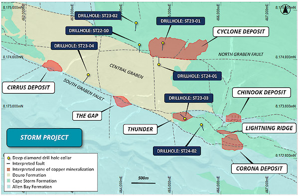
Figure 2: Plan view of the Storm area showing the geological interpretation, known copper deposit outlines, major faults, and deep diamond drill hole locations.
The drill holes have intersected 21.3m and 99.2m of visual copper sulfides (respectively) within what is interpreted to be the equivalent of the same mineralized stratigraphic horizon as the prior deep drilling. The discovery of copper mineralization in these new locations highlights the potentially laterally extensive nature of the deep copper system, which now covers an area of over 10km2. The reader is reminded that the intervals are variably mineralized and that lateral continuity of the mineralization in these very widely-spaced drill holes has not yet been demonstrated.
The 400m x 400m loop MLEM survey has also now been completed in the Storm area. The survey has identified several high-priority anomalies including a large, late-time anomaly located beneath the Cirrus Deposit and The Gap Prospect. The anomaly has the known extents of 1,300m x 500m and is strongest along the Southern Graben Fault. The third 2024 deep diamond drill hole is currently drilling this MLEM target. The deep search EM is now surveying the Tornado and Blizzard Prospects.
DRILL HOLE ST24-01 DETAILS
ST24-01 was drilled to a downhole depth of 407m and intersected a single main zone of visual copper mineralization (Table 1). The drill hole was designed to test the geology and structure within the Central Graben and was located to the south of the Cyclone Deposit (Figure 2).
The mineralized zone encountered within ST24-01 was intersected between 293.7m and 323.5m downhole and contains a total of 21.3m of visual copper mineralization within three sub-intervals (Table 1).
The visual copper mineralization consists of veinlets and matrix breccias with copper sulfide fillings and cement (Figure 3). Large blebs of native copper are present within the visually strongest mineralized interval between 302m and 304.43m downhole.
The visual copper mineralization is hosted within a thick sequence of fractured dolomudstone of the Allen Bay Formation, the main host of the copper mineralization within the Storm area. The highly fractured and brecciated nature of the mineralized zone suggests that the drill hole may have intersected a mineralized portion of the interpreted Northern Graben Fault.
The mineralization and stratigraphy within ST24-01 are visually very similar to that encountered within previous deep exploration drill holes at Storm, highlighting the potentially laterally extensive nature of the prospective copper horizon. ST24-01 also confirms the prospectivity of the Central Graben where recent shallow Reverse Circulation (RC) drill hole SR24-09 intercepted 15.2m @ 1.4% Cu from 103.6m downhole, in what is interpreted to be a down-dropped zone of mineralization similar to the near-surface Cyclone Deposit (see August 15, 2024, Aston Bay news release).
Now confirmed to host both shallow and deeper mineralization, the large and relatively unexplored Central Graben will be a key target for follow-up drilling.
Visual estimates of mineral abundance should never be considered a proxy or substitute for laboratory analyses where concentrations or grades are the factor of principal economic interest. Laboratory assays are required to determine the presence and grade of any contained mineralization within the reported visual intersections of copper sulfides. Portable XRF is used as an aid in the determination of mineral type and abundance during the geological logging process.
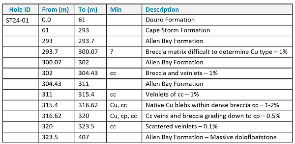
Table 1: Summary geological log for drill hole ST24-01. Mineralization key: cc = chalcocite, cp = chalcopyrite, br = bornite, py = pyrite, Cu = native copper, ct = cuprite, ml = malachite, sph = sphalerite, ga = galena. (5%) = visual estimation of sulfide content.
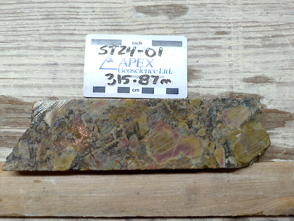
Figure 3: Chalcocite (dark grey) breccia and native copper (metallic) blebs within fractured dolomite in drill hole ST24-01 from approximately 315.87m downhole.
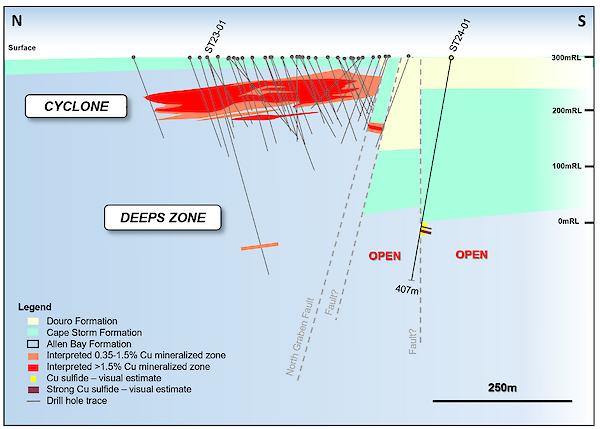
Figure 4: Schematic geological section at 464730E showing the Cyclone Deposit outline, mineralized intervals in existing drilling outside of the resource, and visual copper sulfide estimates for ST24-01.
DRILL HOLE ST24-02 DETAILS
Drill hole ST24-02 was drilled to a downhole depth of 455m and intersected a total of 99.1m of visual copper sulfide mineralization within two main stratigraphic horizons (Table 2). The drill hole was designed to test the stratigraphy and structure in the southern areas of Storm, south of the Southern Graben Fault.
The upper zone of visual copper mineralization is hosted within the Cape Storm Formation at approximately the same depth as the known near-surface copper deposits at Storm (Figure 6). The Cape Storm Formation is not typically mineralized, but here contains multiple sub-horizons from the surface that are weakly mineralized with intermittent and patchy veinlets of visible chalcocite and chalcopyrite to approximately 54m downhole.
Below this, and to the end of the hole, the drill hole intersected the Allen Bay Formation, the typical host of copper mineralization at Storm.
The entire Allen Bay Formation dolomite within ST24-02 is variably fractured and contains visual copper sulfides hosted within the more fractured layers. Twelve separate visibly mineralized zones have been logged, with the strongest visual copper sulfides located between 195.5m and 196.6m (Figure 5), and 204m and 205.3m downhole respectively.
Chalcocite is the dominant copper sulfide mineral, with minor chalcopyrite and bornite present in veinlets and patchy blebs locally filling vugs along with bitumen (Figure 5).
The large volume of visual mineralization within ST24-02 highlights the potential scale of the copper system at Storm. The proximity of drill hole ST24-02 to the Thunder Prospect, and Chinook and Corona deposits provides further evidence that the Allen Bay Formation within the Southern Graben may host high-grade, stratigraphic- and structurally-hosted copper deposits similar to those of the Central African Copperbelt.
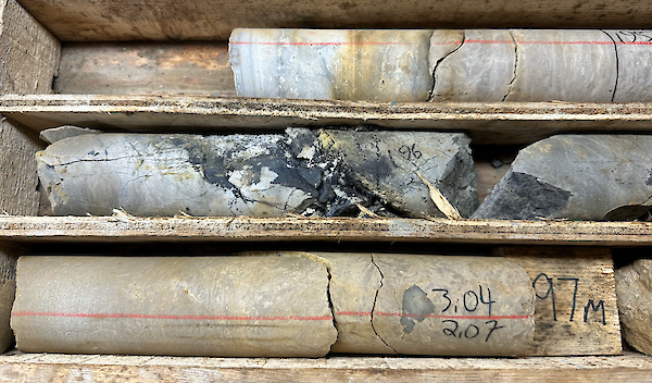
Figure 5: Chalcocite (dark grey) fracture fill in drill hole ST24-02 from approximately 196m downhole.
Visual estimates of mineral abundance should never be considered a proxy or substitute for laboratory analyses where concentrations or grades are the factor of principal economic interest. Laboratory assays are required to determine the presence and grade of any contained mineralization within the reported visual intersections of copper sulfides. Portable XRF is used as an aid in the determination of mineral type and abundance during the geological logging process.
Table 2 below: Summary geological log for drill hole ST24-02. Mineralization key: cc = chalcocite, cp = chalcopyrite, br = bornite, py = pyrite, Cu = native copper, ct = cuprite, ml = malachite, sph = sphalerite, ga = galena. (5%) = visual estimation of sulfide content.
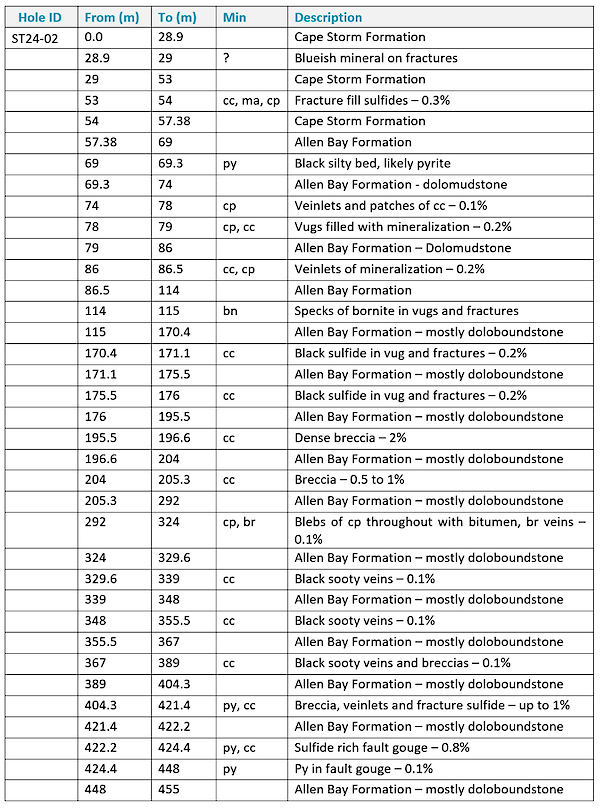
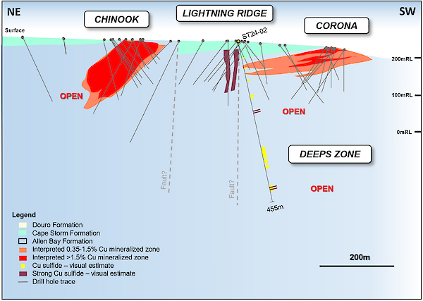
Figure 6: NE-SW orthographic geological section at approximately 465900E showing the Chinook and Corona deposit outlines, and visual copper sulfide estimates for Lightning Ridge and ST24-02. Note – drill hole ST24-02 is located within the Corona fault-bound sub-block and is approximately 300m off section to the west. The combined section is used to illustrate geological relationships.
DEEP MLEM SURVEY DEFINES DRILL TARGETS
Phase 1 of the high-powered Moving Loop EM (MLEM) survey was completed at Storm area during the spring exploration program and was optimized to screen the top 200m of the stratigraphy (see May 7, 2024, Aston Bay news release). Over 10 new high-priority shallow targets were defined and are currently being tested with RC drilling.
Phase 2 of the MLEM survey was planned to search deeper, below the known copper deposits, and has also now been completed in the immediate Storm area (Figure 7). The survey was designed with larger loop sizes (400m x 400m loops) and was optimized to screen between approximately 200- 500m vertical depth.
The survey has identified five strong EM anomalies located in favourable locations within the large graben-fault network. Two of these anomalies are related to known high-grade copper sulfides at the Cyclone Deposit and recently discovered Gap Prospect.
Two other new anomalies are located in untested areas to the south of the Southern Graben Fault, proximal to known high-grade copper occurrences.
The largest of the southern anomalies is interpreted to be approximately 1,300m x 500m, flat-lying, and located at depth below the Cirrus Deposit and Gap Prospect (Figure 7). A series of large, sub-vertical EM plates have been modelled where the northern edge of the anomaly is truncated at the Southern Graben Fault, which suggests that this could represent fault-hosted copper mineralization. This target is currently being tested with diamond drilling.
The ongoing MLEM surveys are currently underway in the Tornado and Blizzard areas, located approximately 10km along strike to the east of Storm. The geological setting is interpreted to be identical to that of Storm and contains numerous outcropping copper occurrences with coincident geophysical anomalies.
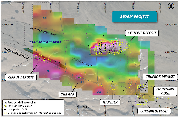
Figure 7: MLEM image (CH20BZ) overlaying drilling and the geological and structural interpretation of the Storm area. The MLEM anomalies discussed in this report are labelled A1- A5.
PLANNED PROGRAM
- RC drilling continues in the Storm area with the track-mounted drill rig on delineation drilling and high-priority geophysical targets.
- The fly RC drill rig is currently drilling at the Tempest Prospect.
- Diamond drilling is in progress on the third deep exploration target in the Storm area.
- The next round of assays for the summer drill program is expected within the next 1-2 weeks.
- Deep-searching EM surveys are underway in the Tornado and Blizzard copper prospect areas.