Just Thinking Out Loud Last year 2023 & this year seen alot of in-fill drilling expanding the Cyclone and Corona area which should have satisfied the agreement with Taurus . The 200,000 tns indicated resource @ Cyclone should now be reclassified IMO to indicated Proven Resource & 200,000 tons indicated reserves upto indicated resource.
IMO, The 200,000 tons indicated proven in the new JORC would allow AWM to complete their PFS. The Logistics started 2 years back seeing this now JORC with proven resources IMO would advance the next phase .
IMO..A bankable feasability study when complete would be when BAY has to make a decission on to pay up or DEAL.
IMO,..Now that Nunavut Goverment has control of all their own Jurisdiction including all mining rights, the Federal Government only control may-be Political on Foreign takeovers.
BAY-AWM,.having on-going dialouge with Nunavut Minister may be looking to advance the time line for the DSO. seeing the 200,000 tons proven sitting on surface only 15k from Sea-Lift.
Deep holes 2024, 1, 2 & 3
Vectoring into the Sediment Base
Hole 2024: 1,2 . stepping away from the Cyclone deposit and drilling deeper into the sediment hole 1 tag the Horizon @ 325 depth area. Vectoring South deeper into the sediment hole 2 tag the horizon at the 400 m depth expanding the horizon..
PS,..Hole * 3 . Vectoring 1000m South from hole 2 going 600m deep below the 3500 ( Ciruss ).
The old 3500 zone now called Ciruss zone, was once thought tobe to deep to drill . Now seeing AWM with new EC technoligy being able to penetrate with deeper current and recieve a better 3d reading on structure below.
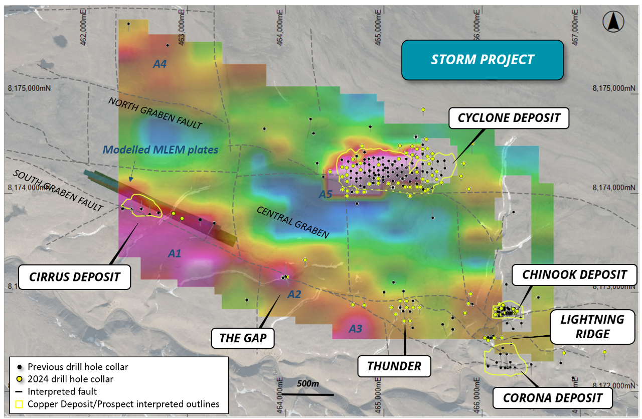
PS,.Notice here on latest image 1 showing the Label Cirrus Deposit. Look below the Banner label and and notice what looks like a grey structure or fault . Look at the scale meter and notice the dimension being te size mentioned in news release 1400m x 500m ..Notice here ( truncated at the Southern Graben Fault, ) see the twist in fault below the label Ciruss,, here sits hole 3 target..Image - 1
The largest of the southern anomalies is interpreted to be approximately 1,300m x 500m, flat-lying, and located at depth below the Cirrus Deposit and Gap Prospect (Figure 7). A series of large, sub-vertical EM plates have been modelled where the northern edge of the anomaly is truncated at the Southern Graben Fault, which suggests that this could represent fault-hosted copper mineralization. This target is currently being tested with diamond drilling.
Let The Drills Be Our Friends
Traps7