Join today and have your say! It’s FREE!

Become a member today, It's free!

We will not release or resell your information to third parties without your permission.
Please Try Again
{{ error }}
By providing my email, I consent to receiving investment related electronic messages from Stockhouse.

or

Sign In

Please Try Again
{{ error }}
Password Hint : {{passwordHint}}
Forgot Password?

or

Please Try Again {{ error }}

Send my password

SUCCESS
An email was sent with password retrieval instructions. Please go to the link in the email message to retrieve your password.

Become a member today, It's free!

We will not release or resell your information to third parties without your permission.
Quote  |  Bullboard  |  News  |  Opinion  |  Profile  |  Peers  |  Filings  |  Financials  |  Options  |  Price History  |  Ratios  |  Ownership  |  Insiders  |  Valuation

Bullboard - Stock Discussion Forum Sixty North Gold Mining Ltd C.SXTY

Alternate Symbol(s):  SXNTF

Sixty NorthGold Mining Ltd. is a Canada-based company, which is developing mining operations for gold on the 100% owned Mon Gold Property, approximately 40 kilometers (km) north of Yellowknife, Northwest Territories (NWT). The Mon Gold Property consists of over 13 contiguous mining leases encompassing approximately 494.28 hectares and one mineral claim, comprising an additional 127.75 hectares,... see more

CSE:SXTY - Post Discussion

View:
Post by Wangotango67 on Jul 15, 2021 1:02am

BREAKER

If you read my former post  and actually looked at Gold Terra's diagrams - you'd have seen that their maps point out the geology - sediments. ( GREY ZONE COLORATIN )
Check it out - ytou'll see that i'm correct.

While i have the post open i may as well speak about - Clan Lake.

Clan Deposit - is a mere 5km from the Moin Mine .
Gold Mining Inc owns this Clan claim - actually 5 claims that total a good 2 million ounces.
Good to know there's another nearby whose with a reported gold resource.

Mty own take on Gold Mining inc ?
5 deposits = 2 million ounces.
Could suggest = individual pillar style deposits.
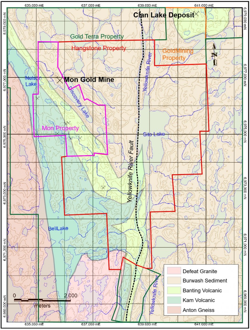
  

https://www.juniorminingnetwork.com/images/jmn_feeder/newsfile/SXTY68716_sixty.2.jpg-5fbbc151a0fe7-875px.jpg


Looking at the map above - where it says - Hangstone property
Specifically - HAN
The lake just underneith it.

I was scanning a satalite map and i'm pretty sure i see red oxide sands/rocks.
i wonder if this was ever checked for - iron oxide copper ?

MAP OPENS AT - NELSON LAKE
Scan a few km's north and you'll see the small lake - look for the distinct reds atop the earth.
Another lake just north west of this... zoomed in - i can see reds all around the perimeter of
its shoreline - underneith this red earth is light colored sands - interesting.

GOOGLE MAPS
https://www.google.com/maps/place/Nelson+Lake/@62.9516507,-114.4426032,19187m/data=!3m1!1e3!4m5!3m4!1s0x53d22e75e6c91e4d:0x59a580f19885be39!8m2!3d62.8966346!4d-114.3495753?hl=en-US


 I see some just don't like another speaking about geology.
Perhaps i won't post anymore.

Cheers....
Be the first to comment on this post
The Market Update
{{currentVideo.title}} {{currentVideo.relativeTime}}
< Previous bulletin
Next bulletin >

At the Bell logo
A daily snapshot of everything
from market open to close.

{{currentVideo.companyName}}
{{currentVideo.intervieweeName}}{{currentVideo.intervieweeTitle}}
< Previous
Next >
Dealroom for high-potential pre-IPO opportunities