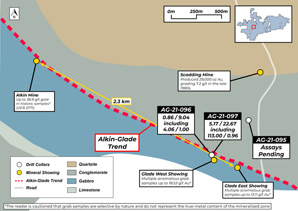
An important drill hole.
A hole that could tie in Scadding district with Glade.
RUNNING NORTH - SOUTH North Pit - top end
Main Pit
South pit
Powerline
Glade
Glade Trend - sweeping towards Murry Bay
 BIRDSEYE VIEW OF SCADDING MINE
 If 've read this correctly - Ashagami road off to extreme left with perhaps teh tip of Ashagami lake, Scadding mine cloeset in view, then, South Pit, Powerline, and is that
the Glade zone off in the distance seen with new exposed ground ?
I do like the outcropped banks along the- Wanapatei River - off t oright side.
Again - i hope i have the right coodinates - looking from North to South, my luck it's reversed
and it's seen in pic as - South to North - lol.
 SHALLOW - NEAR SURFACE GOLD
 An anomaly in itself - al lthe gold seems to be all upper strata.
Could this have bene caused by a low lying volcano that gushed low pressure hydrofluids ?
It would make so much sense - if this were the correct answer -
3 pits already align,
Powerline would make it a 4th connective to Scadding..
Glade would would make it the 5th connective.
Running North to South.
Yet... could there be a sweeping pattern emminating form Wanapatei whereas, the 2 upper bays along with murray bay are sweeping into the Scadding and Glade inwhich carried in the gold ?
 Here's an interesting pic - wanapatei river -
 open the picin a new window -
look lcosely at the geology - i'm seeing somesort of - mafic sedimentry volcanics ?
https://i.ytimg.com/vi/69hENdJYWKY/maxresdefault.jpg Here'a a good contour map of Lake Wanapatei I'm seeing potentially 2 good - fault lines -
https://www.gpsnauticalcharts.com/static_html/nautical_charts_app/nautical_chart_images/CA_ON_V_103384706.jpg WHAT'S IMMEDIATE NORTH OF - NORTH PIT ? Red Rock mine - ( copper + Gold )
History: 1898-1903: Two adits; vertical 3 compartment shaft to 420 feet; levels at 100, 200, 300; 606 feet of lateral development on surface from 100 foot level. 1899-1903: Production 1 524 000 lbs. copper from 43 300 tons of ore, by Rock Lake Mining Co. Ltd. Geology: A stockwork of discontinuous quartz-carbonate-chalcopyrite veins in a fault zone, which strikes N55W and dips 90 to 70 N, has an average width of 50 to 100 feet. It has been traced by drilling for a strike length of 1000 feet and by surface prospecting for a length of 2 miles. LINK - https://www.mindat.org/loc-254800.html Makes one all the more interested in those Scad - black crystal - like ores.
Could the pyrite seen in photo be - chalcopyrite ? ( copper )
Could the black gem like crystal be - chalcocite ? ( copper )
Here'a a link that portray a historical map of the mines and surroundings around Scad
Page - 3
https://www.google.com/url?sa=t&rct=j&q=&esrc=s&source=web&cd=&cad=rja&uact=8&ved=2ahUKEwi5p4HSj4fxAhWVXM0KHRptBDcQFjABegQIAxAE&url=http%3A%2F%2Fwww.geologyontario.mndmf.gov.on.ca%2Fmndmfiles%2Fpub%2Fdata%2Fimaging%2FP2228%2FP2228.pdf&usg=AOvVaw2ZkMDw6XG0pkpErvBnS8p_ SOUTH to NORTH Glade
Powerline
South Pit
Main Pit
Norrth Pit
Red Rock Mine - could this be a 5th alignment - tie in ?
WEST OF SCADDING Lies the Bonanza Lkae Mine.
Quite close ot the 1800 ft long vein or dyke at surface.
Appears BMK has showing on almost all sides of it's main focal - Scad Mine.
And then there's... the Uranium showing - immediate west of Scad Mine.
I'd like ot see a few holes tapped in this area - just ot see if there's also gold in alkai geology.
And then there's ... Alwyn Mine - north of, Scadding Main Mine. ( BMK press )
https://www.globenewswire.com/en/news-release/2019/09/09/1912585/0/en/MacDonald-Mines-Acquires-Additional-Prospective-Targets-and-Expands-its-SPJ-Iron-Oxide-Copper-Gold-Property.html Cheers....