If one researches the historical timeline of the Bul lRiver Mine,
One will soon conclude the mine took too long to bring to prodcution, and once production started the pits were targeted first - then, the scamble to find more mineralized ore bodies
created the second half of the hidtorical timeline with the endevor of building the underground mine.
The 2 pit ore bodies were mined and more drills punched on the outlier areas around the pits - but, as the story unfolds - no new minerlaization was encountered cept for a specific region with coordinates only given.
Lots of info on the bul lmine but, very vague with barely any drill data to go on inwhich another could map out the area ot determine whats really going on.
Pictures speak volumes -
Take a look at this photo again and focus on the arm branches and follow the ridges or arms that extend down to the valley. Take notice of the sands - placer sands - theyre everywhere, even coating the lower ranges -

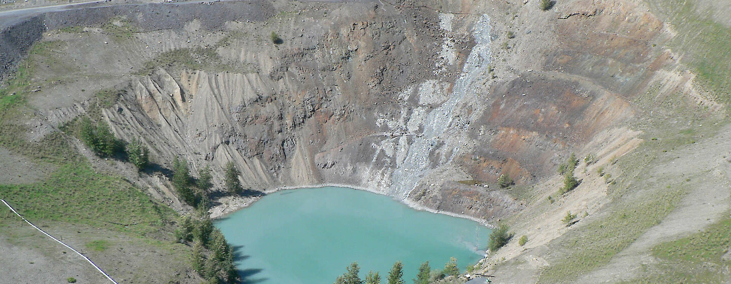
Now focus on the open pits - we can see the sulphide mineralization - and if one punched holes to the left or right of pits and supposing drills didnt intercepted minerlaization - then...
this is where one should look at the spacing in between the pits and theorize that this might be the baren sands that harbor no sedimentry banding. Take notice of the stratography that can be seen atop themountain and the nfactor in, the seismic thrusts that controted the strataboud ranges .
Not all mountains were volcanoes.
Theres such a thing as - reweldedores or reconsolodated ores that als form sedimentry strata layers. Bull River Mine is at the base of the foothills, and as so, lots of overburden sands cover the extension arms that stem from the mountains.
Being in the valley, the odds of hitting the stratabound ore body decreases due to the overburden sands - hence, drills that did not hit the minerlaization on either side of the pits.
Which points to - miner should gravitate towards the ranges to increase higher odds of hitting the stratabound sediments and by doing so the reduction of sands will decrease.
If microwave technology can penetrate rocks and determine the density - which usually points ot minerals in dense format - then.. it would be interesting to see technology develop satalite microwave surveys to track such stratabound depoists based on density inwhich ot peer through placer sands.
In this picture below - we can see the axis point of where placer sands meet the sulphide ore body. I would say theres more to this story - those darker sulphides look a near match ot the ores belwo grade which are minerlaized.
I wonder if anyone knows if this ope ncut section has ever been trsted for minerals And in my own opinion - it appears as a lower extension arm that ties in with the ranges.

In the next photo below - we can see this ope npit with sulphide mineralization.
But if one looks real close - theyll see theres more going on.
Such as the apparent sands that flank the sulphide ore body.
Could the mineralization extend towards the left beyond the mine road or, is it more like a lower extension arm inwhich miner should track it towards the mountain ranges
Obvious answer is... track the mineralization towards the mountain ranges.
So.. could thids be as simple as...
Extrension arms that eminate from the ranges and if one is lower in the valley it becomes a
hit and miss due to pockets of pockets of placer sands fil lthe voids
Could very well be the case.
But... i would also factor in, sedimentry stratabound beds that may have been fratured and
imparted away from its main strata sheet ore body creating parcels of strata bound ore depoists.
lets play suppose - suppose the mine was in alignment of the arm extension facing the mountain ranges.
It would mean the mine was build perpendicular to the true ore body - thus... chasing the ore body would require a realignment facing the ranges where an extension arm could be identified.
If one looks real close - theyl lsee the stratabound formation - left side- on angle - where
rbanding formation rocks can be seen in the pit.
Its the ability of extrapolating al lthe gems of the historical and retelling the story with all
the best highlights - and... deciphering the ore bodies inwhich to make sense of whats going on so investors can say - yeah... thats exactly whats going on - that makes sense.
Could be as simple as... current owner braveheart testing these feeder arms in pit and outside of pits and tack towards the ranges where ewxposed outcrops are apparent - proving the copper is in continuence. Boom, the Bull river story comes aloive.
Chasing veining belwo grade - while tech reports also revela argilites also contai nthe copper This tells me- the copper is not retrictive to just veining which opens up all sorts of ideas including - stratabound sediments that may have formed in layers and extension arms. Theres a difference betwene promoters like last operator and a true blue miner- Braveheart could add to this storyline - beef it up- with just a few more tweaks.

veerr