Join today and have your say! It’s FREE!

Become a member today, It's free!

We will not release or resell your information to third parties without your permission.
Please Try Again
{{ error }}
By providing my email, I consent to receiving investment related electronic messages from Stockhouse.

or

Sign In

Please Try Again
{{ error }}
Password Hint : {{passwordHint}}
Forgot Password?

or

Please Try Again {{ error }}

Send my password

SUCCESS
An email was sent with password retrieval instructions. Please go to the link in the email message to retrieve your password.

Become a member today, It's free!

We will not release or resell your information to third parties without your permission.
Quote  |  Bullboard  |  News  |  Opinion  |  Profile  |  Peers  |  Filings  |  Financials  |  Options  |  Price History  |  Ratios  |  Ownership  |  Insiders  |  Valuation

Bullboard - Stock Discussion Forum Hawkeye Gold and Diamond Inc V.HAWK

Alternate Symbol(s):  HWKDF

Hawkeye Gold & Diamond Inc. is a junior mineral exploration and development company. The Company is engaged in the exploration for and the development of natural resources in Canada. Its projects include Bonanza, 2-Aces, Keithley Creek, Cariboo Valley, Seller Creek, Swift River, Bonanza Lake and Cariboo Lake. The Company owns over four 2% royalty interests which are subject to buy-down... see more

TSXV:HAWK - Post Discussion

Hawkeye Gold and Diamond Inc > MCBRIDE + RAILWAY
View:
Post by Wangotango67 on Nov 07, 2021 1:43pm

MCBRIDE + RAILWAY

Here's a Hawk map depicting where a 2019 drill program tapped one hole.

Where should they have drilled ?
Exactly on the Railway proerty where they sampled very good copper + silver findings.
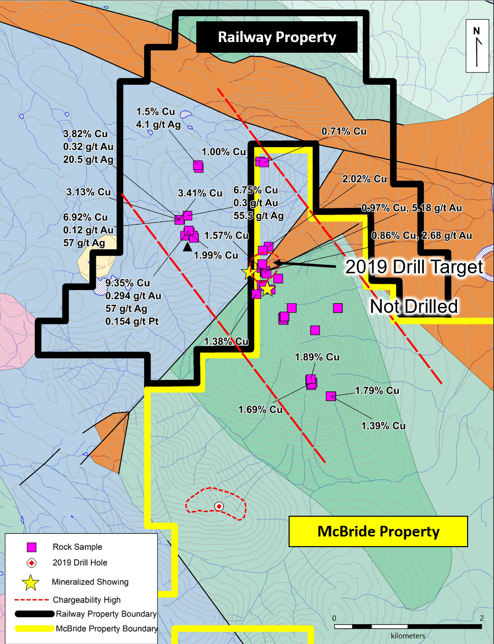
https://hawkeyegold.com/wp-content/uploads/2021/06/McBride-and-Railway-geology-2-June-16-2021.png


Here's a mapcarta map pinpointing Tahtue Mountain.
Reference the mineral samplings map and then compare to the Mapcarta map.

There's distinct vein like outcrops that exude a grey ore.
A good 3km east to west " grey ore  rock showing "
spans the area where it says - not drilled.


The 2019 drill hit an area of totally different geology.
Appears as if it might be on another range unassociated to the core copper silver findings.

i would think... a drill program of 500m would do wonders.
Tapping 10 holes 50m each along this 3km exposed strike might be the -  fix.
That 2019 loner hole is a real head scratcher - given - all the best results of samplings is where the drills should've hit.

Heck... even a winkie drill running 25m each hole - cut the costs - would reveal lots.
Given the outcrops are right at surface. 

Thosr are some nice copper + silver samples.
I wonder if there's zinc ?
I did notice platinum was also in the mix.
Surprise, surprise.

I also reccommend Hawk to test their 2019 dril lcores with their - XRF.
As one can read, in prior posts.... copper can take on all sorts of bonds.
In this McBride area. other miners have 2 kinds of copper.
Just saying...

I also think.. the 4-5 finger arms off to right side of map, of Mt Thateu looks similar to the
ores in the 3km strike zone. Appears loose tills are easily accessible to test.

https://mapcarta.com/24672178

From the word - Mount Thateu
is where the snaking grey outcrop is located.
An unusual - oviod - is positioned almost center of this 3km grey strike.
Interesting it is... water pocket ? volcanic related ?


Cheers...
Be the first to comment on this post
The Market Update
{{currentVideo.title}} {{currentVideo.relativeTime}}
< Previous bulletin
Next bulletin >

At the Bell logo
A daily snapshot of everything
from market open to close.

{{currentVideo.companyName}}
{{currentVideo.intervieweeName}}{{currentVideo.intervieweeTitle}}
< Previous
Next >
Dealroom for high-potential pre-IPO opportunities