TSXV:TRO - Post Discussion
Post by
TrumpThis on Aug 11, 2023 12:24pm
Top 10 Reasons to have TRO in Portfolio: #8
#8: Connections! When the Western tectonic plates hit the main North American plate mountain ranges were formed. When volcanics occured cracking occured and we have a string of valuable PM and base mines from Argentina to Mexico to Utah Yukon/Alaska.
If we run a line from Bingham Canyon, Utah, the world's largest opeh-pit mine, established in 1906 and currently down to 1,200 meters and 4,000 meters width, all the way to the Brucejack Mine in the Golden Triangle, via all the Boise Idaho mines, who can see the connection to BC projects, including Taranis at Trout Lake, in SE BC.

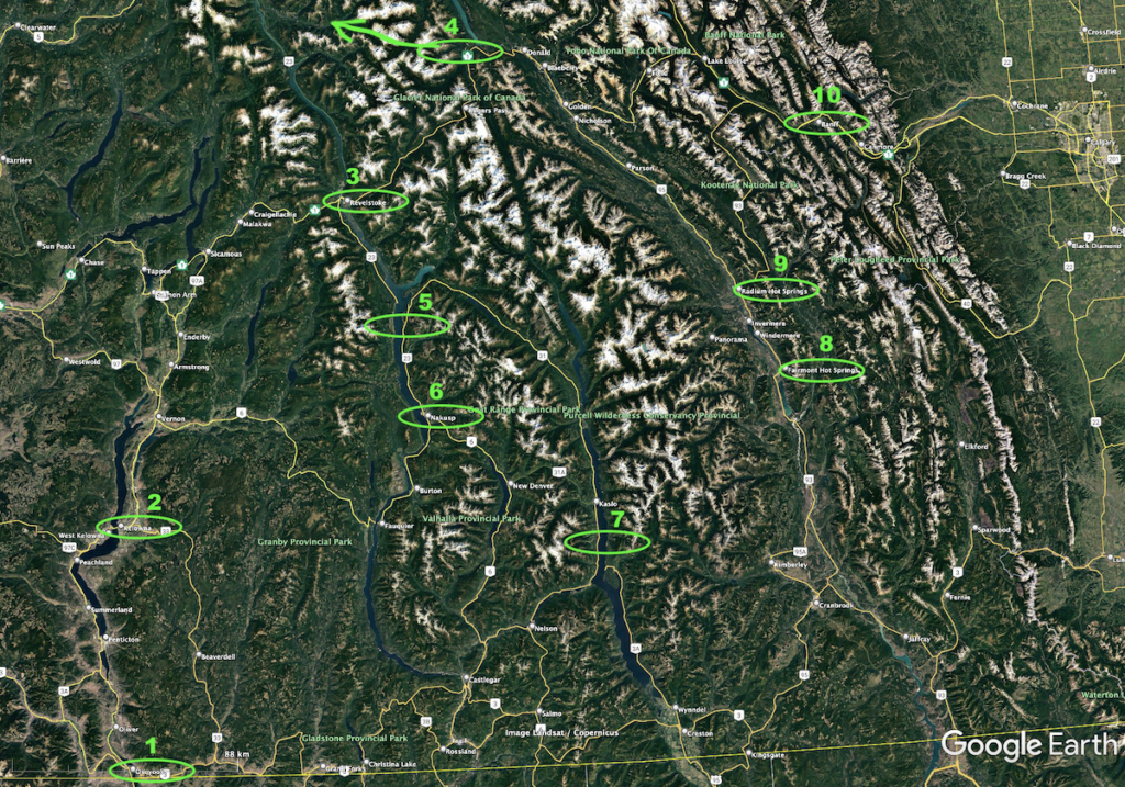
While you are at the comparisons, look at the geothermal activity in the larger hot springs in BC & AB - in particular #5 at Halycion, and #6 at Nakusp: https://landscapes-revealed.net/why-are-there-so-many-hot-springs-in-southeastern-british-columbia/#:~:text=The%20gradient%20is%20about%2025,where%20the%20temperature%20is%20hot.
 The route of our BC hot springs geology tour. A friend from California and I drove to BC, crossing the border into Canada (yellow line) at Osoyoos (location 1). We continued north through Kelowna (location 2) to Revelstoke (location 3), where we met the rest of the group. On an extra day, we traveled north to Mica Dam (location 4—off the map, on the Columbia River north of Revelstoke), one of the largest earthen-filled dams in the world. The next day, May 1, twenty of us headed out in car pools to complete a counter-clockwise loop from Revelstoke. We went south and used a ferry to cross Arrow Lake and arrive at Halcyon Hot Spring resort (location 5), where we spent two nights. We continued south to Nakusp (location 6) where we visited two hot spring locations in the woods, then traveled east to Ainsworth Hot Spring resort (location 7), where we stayed two nights. Our route swung north to Fairmont Hot Spring resort (location 8) and Radium Hot Springs (name of both the town and the hot springs at location 9), where we spent two nights. We continued northeast into the western edge of Alberta to soak in the Banff hot springs (location 10) and stay at the Fairmont Banff Springs, a venerable hotel that has been pampering guests since 1888. This range of mountains, with the well-known Banff and Jasper National Parks, is what most people think of when they refer to the Canadian Rockies. From Banff, we completed the loop, going back to Revelstoke and the mountains extending south from Revelstoke—the Kootenay Rockies—where we had spent most of our time. Finally, we returned to Kelowna, where I flew home on May 12.
 DASH DEPOSITS - A NEW GENERATION OF PORPHYRY TARGETS IN BRITISH COLUMBIA
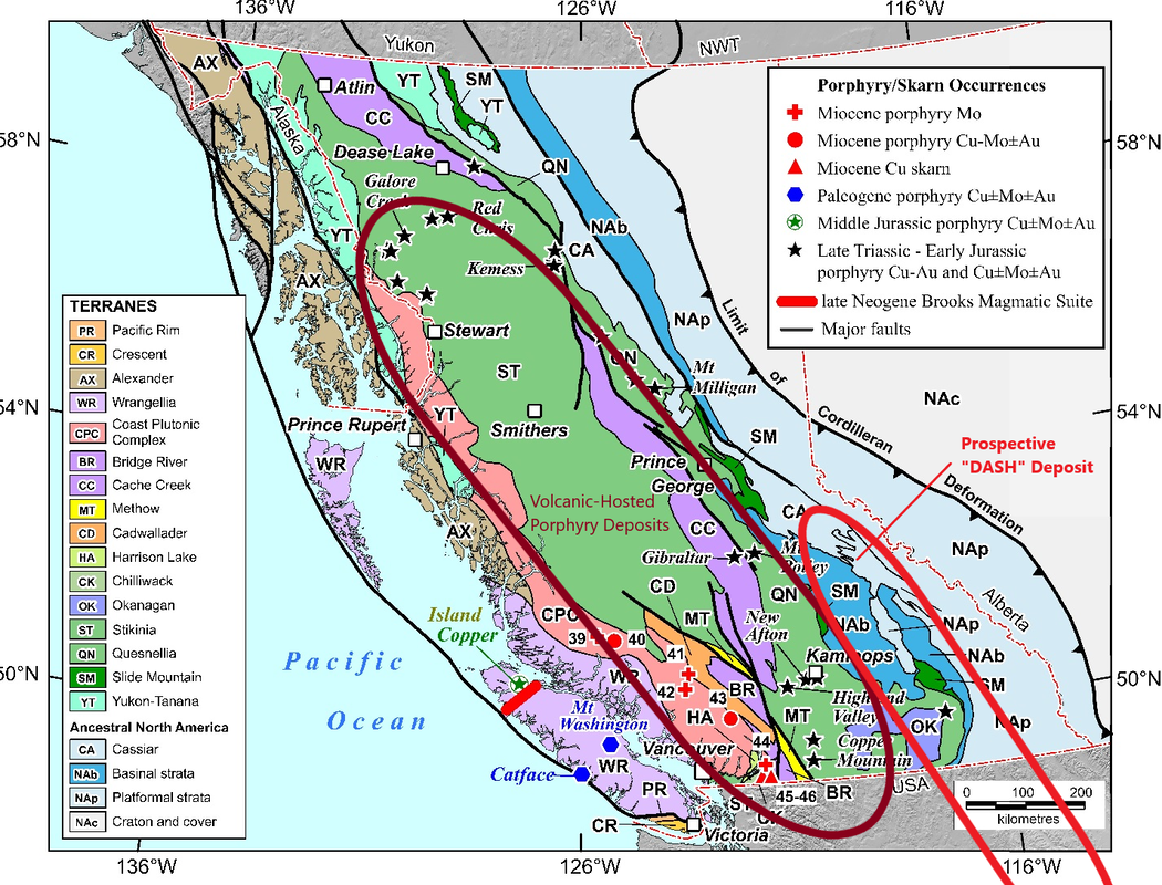
 Map of British Columbia showing the location of some of the porphyry deposits in relation to geological terranes (from Nixon et al., 2020) | Porphyry deposits occur throughout much of British Columbia, as do epithermal deposits. Most of the porphyry deposits are late Triassic to Early Jurassic in age, and occur in the Stikinia or Quesnellia Terranes. This includes the largest deposits such as Mt. Milligan, Gibralter, Red Chris, Galore Creek, New Afton and Highland Valley.
Thor (and the nearby Max Mine) occur within rocks that are considered part of ancestral North America that occur west of the North American Craton. This includes basinal rocks that are for the most part sedimentary rocks, that are derived from the weathering of the North American Craton.
Absent from the map is the Max porphyry located just 8km southwest of Thor, and it occurs in largely sedimentary rocks to the east of the Stikinia and Quesnellia Terranes. We believe that this is prospective ground for B.C.'s next generation of porphyry deposits. DASH deposits are 'Deep Apex Sediment Hosted' Deposits, and geologically they are very different from the classic volcanic-hosted porphyry deposits found in the Stikinia and Quessnellia Terranes. |
I'm no geo, only an investor who digs the data and growth. 'Get' the picture yet? GLTA
Be the first to comment on this post