(TheNewswire)

Highlights:
-
Based on these excellent results, a large exploration program is planned for summer 2022 at the Lac Brulé and Lac Brennan properties. Exploration works will include geological mapping and sampling, ground geophysical survey aimed at drilling priority targets by the fall of 2022. An existing vast network of forestry roads and bridges will greatly facilitate access for all our exploration works.
Montréal, Quebec – TheNewswire - March 22, 2022 – Sama Resource Inc. (“Sama” or the “Company”) (TSXV:SME) | (OTC:SAMMF) is pleased to reportthatSama Resources Québec Inc. (“SRQ”) a fully owned subsidiary of the Company has announced the completion and interpretation of a HELITEM2 electromagnetic and magnetic helicopter geophysical survey of 1,494 line-kilometres (line-km) at the new Lac Brulé nickel-copper property in the Province of Québec, Canada (Figure 1).
As a follow-up on the new gossan discovered in May 2021 (see Press Release 2021-06-16)*1,SRQcommissioned Xcalibur Multiphysics (MPH) Canada Inc. for a HELITEM2 electromagnetic survey supplemented by a high-sensitivity cesium magnetometer. One block of claims (390 claims) was flown between December 5 and December 14, 2021. The survey coverage consisted of 1,374 km of traverse lines flown with a spacing of 200 and 100 metres (“m”) and 119 km of tie lines with a 2000 m spacing.
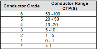
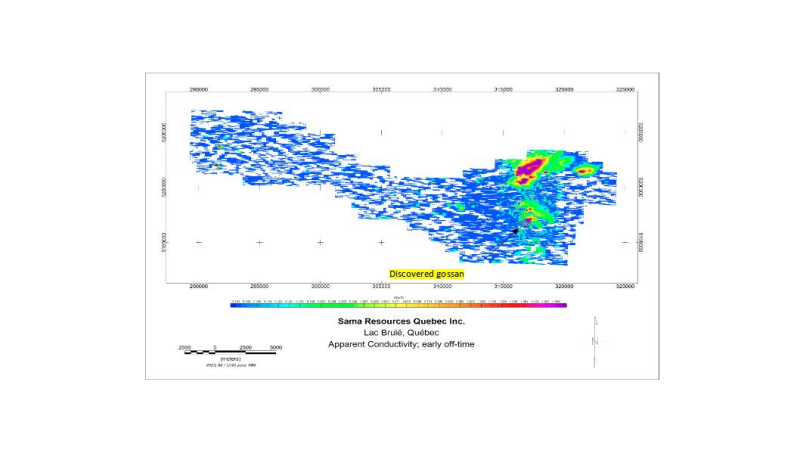
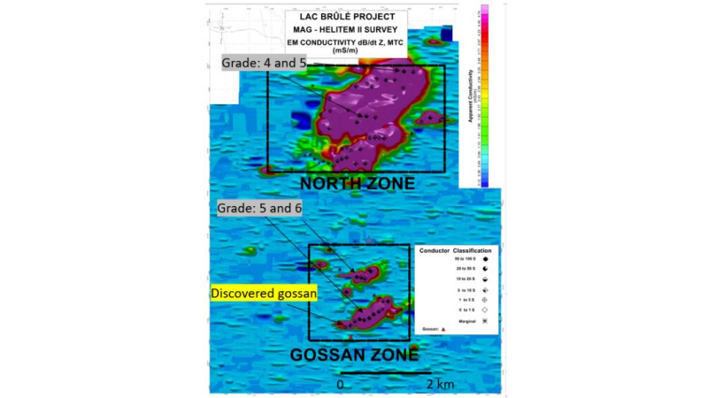
Figures 2 to 5 show Xcalibur’s final compilation outlining several high conductivity-thickness-product (“CTP”) areas grading 5 to 6 on the Conductivity Grade scale (Table1). Highest Conductivity Grade and CTP, outlined by the late off-time channel/gates (Figures 2 & 5), are located next to the discovered gossan. Figure 6 shows the rooted EM response down to 600 m from surface. Detailed Interpretation and targets modeling will be performed by M. Joel Simard,P. Geol./Geoph based in St-Donat, Quebec province, Canada.
*1(Gossans are highly ferruginous rock which is the product of the oxidation by weathering and leaching of a sulfide body: Elsevier Mineral Exploration 2013)
“While we are fully committed at exploring and developing our Ivorian Samapleu Ni-Cu-PGM assets with our partner Ivanhoe Electric, Sama is demonstrating its ability at finding new highly prospective grounds worldwide in totally virgin territories.” said Marc-Antoine Audet, Ph.D, P.Geo and CEO of Sama Resources Inc. Dr. Audet is continuing by saying “SRQ’s 100% owned Lac Brulé project is only 5 hours driving north of Montreal, Québec Province, which greatly facilitate our upcoming explorations programs”
Nohistorical prospecting or ground explorationhadbeenreported from theLacBruléareapriortoSRQ.
Thepast-producingRenzinickel-coppermineistheclosestminingactivitywithhistoricalinformationavailable.TheRenzimineislocated48kmeast-southeastoftheLacBruléproperty.The Company is targeting possible accumulations of Ni and Cu mineralisation at LacBrulé that could be of similar nature to that at the Renzy mine, Voisey Bay Ni-Cu mine and at other well-known Ni-Cu deposits in Canada and worldwide.
Geophysical HELITEM2 electromagnetic Program
The HELITEM2 system is composed of a 40 m cable to which is attached the transmitter loop. The receiver platform and the receiver coil are located at the centre of the 35 m diameter transmitter loop approximately 0.1 m above the centre of the transmitter plane. The real time navigation GPS antenna is on the tail boom of the helicopter. The barometric altimeter, radar altimeter, laser altimeter, video camera and data recorder are all installed in the helicopter. GPS antennae are attached to the transmitter loop to give positional information and transmitter orientation.
The survey used a 7.5 Hertz (“Hz”) one half cycle of the HELITEM2 system is made up of a square pulse (on-time) of approximately thirty-four milliseconds in duration followed by approximately thirty-four milliseconds of off-time before the pulse is repeated with the opposite polarity. After acquisition the measured data are windowed into twenty-five ranges called “gates”. Gate widths increase as time after turn-off increases because as the energy from the transmitter decays a wider sample must be taken to get a valid average. The position of the first off-time gate is selected after examining several flights of data and is as close to the transmitter turn off as possible. The power of the pulse causes eddy currents in the system after the turn off and the first off-time gate cannot start until these have died away. The earliest data has had less time to penetrate the subsurface and so contains information from the near surface. Detailed technical information on the survey is available on Sama’s website.
Xcalibur MPH selected electromagnetic (“EM”) anomalies automatically using proprietary software from both X and Z components using the fourth off-time gate and a threshold of 100 nT/s. These automatically generated anomalies were then examined in profile form for each line against the X & Z EM responses, decay information, magnetic responses, altimeter readings and flight path videos removing those not considered valid and adding additional anomalies missed by the threshold. For each anomaly the conductor type was interpreted and assigned to each anomaly. After reviewing all anomalies, the following parameters were associated with each anomaly using the data for the fourth off-time gate and where applicable: conductivity-thickness-product (CTP) (Table 1), amplitude of EM response, last off-time channel with an anomalous response, time constant, apparent depth and dip.
Table 1: Xcalibur’s MPH (proprietary) EM Anomaly characterisation (Conductor Grade and CTP)
(Fourth off-time gate and a threshold of 100 nT/s)


Click Image To View Full Size
Figure 1: SRQ’s Lac Brulé project is located 148 km West-Northwest of Mont-Laurier and 290 km Northwest of Montreal. The project area is located 5 hours driving north of Montreal. SRQ owns a second block of claims (Lac Brennan) overlying an isolated gravity high in prolongation of the “Renzi shear zone”.The old Renzy Ni-Cu mine operated from 1969 to 1972 selling nickel and copper concentrate to Falconbridge in Sudbury, Ontario.

Click Image To View Full Size
Figure 2: Apparent Conductivity: late off-time channel/gates showing several distinc high conductivity (CTP) areas. The composantes X and Z responses of the strong conductor (Conductor Grade: 5 and 6, see Table 1) located next to the surface gossan is also shown.

Click Image To View Full Size
Figure 3: Apparent Conductivity: early off-time channel/gates. The gossan location is shown with a star.

Click Image To View Full Size
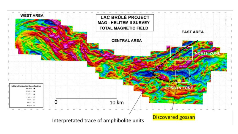
Figure 4: Total Magnetic Intensity for the Lac Brulé project. The interpreted trace of amphibolite units is shown.

Click Image To View Full Size
Figure 5: EM Conductivity together with Conductor Classification defining two main sectors for follow-up: Gossan Zone and the North Zone.

Click Image To View Full Size
Figure 6: Differential conductivity: 600m depth slice.
2022 Exploration Program
SRQ will continue surface exploration at the Lac Brulé and Lac Brennan properties. Exploration works will include geological mapping and sampling, ground geophysical survey aiming at drilling priority targets by the fall of 2022. An existing vast network of forestry roads and bridges will greatly facilitate access for all our exploration works.
Readers are invited to view the updated Corporate Presentation showing exploration progress at all our properties : https://samaresources.com/i/pdf/Sama_Corporate_Presentation.pdf
The technical information in this release has been reviewed and approved by Dr. Marc-Antoine Audet, Ph.D geology, P.Geo and President and CEO of Sama, and a ‘qualified person’, as defined by National Instrument 43-101 Standards of Disclosure for Mineral Projects.
ABOUT SAMA RESOURCES INC.
Sama is a Canadian-based mineral exploration and development company with projects in West Africa and now in Canada.
In Côte d’Ivoire only, Sama, has a strategic partnership to develop the Samapleu-Yepleu nickel-copper-palladium project with Ivanhoe Electric (previously HPX) of which mining entrepreneur Robert Friedland is a significant stakeholder. For more information about Sama, please visit Sama’s website at http://www.samaresources.com.
FOR FURTHER INFORMATION, PLEASE CONTACT:
SAMA RESOURCES INC./RESSOURCES SAMA INC.
Dr. Marc-Antoine Audet, President and CEO
Tel:(514) 726-4158
OR
Mr. Matt Johnston, Corporate Development Advisor
Tel: (604) 443-3835
Toll Free: 1 (877) 792-6688, Ext. 5
Neither the TSXV nor its Regulation Services Provider (as that term is defined in the policies of the TSXV) accepts responsibility for the adequacy or accuracy of this release.
Forward-Looking Statements
Certain of the statements made and information contained herein are "forward-looking statements" or “forward-looking information” within the meaning of Canadian securities legislation. Forward-looking statements and forward-looking information such as “plan”, “evidence”, “potential”, “appears”, “seems”, “suggest”, are subject to a variety of risks and uncertainties which could cause actual events or results to differ from those reflected in the forward-looking statements or forward-looking information, including, without limitation, the availability of financing for activities, risks and uncertainties relating to the interpretation of drill results and the estimation of mineral resources and reserves, the geology, grade and continuity of mineral deposits, the possibility that future exploration, development or mining results will not be consistent with the Company's expectations, metal price fluctuations, environmental and regulatory requirements, availability of permits, escalating costs of remediation and mitigation, risk of title loss, the effects of accidents, equipment breakdowns, labour disputes or other unanticipated difficulties with or interruptions in exploration or development, the potential for delays in exploration or development activities, the inherent uncertainty of cost estimates and the potential for unexpected costs and expenses, commodity price fluctuations, currency fluctuations, expectations and beliefs of management and other risks and uncertainties.
In addition, forward-looking statements and forward-looking information are based on various assumptions. Should one or more of these risks and uncertainties materialize, or should underlying assumptions prove incorrect, actual results may vary materially from those described in forward-looking information or forward-looking statements. Accordingly, readers are advised not to place undue reliance on forward-looking statements or forward-looking information. Except as required under applicable securities legislation, the Company undertakes no obligation to publicly update or revise forward-looking statements or forward-looking information, whether as a result of new information, future events or otherwise.
Copyright (c) 2022 TheNewswire - All rights reserved.