Vancouver, British Columbia--(Newsfile Corp. - September 20, 2022) - Burin Gold Corp. (TSXV: BURG) ("Burin Gold" or the "Company") is pleased to announce gold assay results of 6.0 m of 2.15 g/t Au in the last hole drilled at Hickey's Pond as part of the Company's summer drill program as well as initial drill results from nine diamond drill holes at the Tower showing, both located on Burin Gold's 100%-owned Hickey's Pond - Paradise Gold Property in southeastern Newfoundland, Canada.
Highlights
- Drill hole HP-22-030 assayed composite intervals of 6.0 m of 2.15 g/t Au from 86.0 m (including 1.0 m of 10.64 g/t Au), 7.2 m of 0.40 g/t Au from 23.3 m, and 5.0 m of 0.48 g/t Au from 76.0 m.
- Mapping and geochemical sampling programs were completed over targeted areas across the property, with pending results that will assist in defining future exploration activities.
- Nine initial drill holes were completed at the Tower showing. Drilling results have outlined a large footprint alteration system anomalous in gold including best results of 11.0 m of 0.22 g/t Au in TW-22-001, 18.7 m of 0.18 g/t Au in TW-22-002, 28.0 m of 0.14 g/t Au in TW-22-003, and 8.7 m of 0.21 g/t Au in TW-22-009. The alteration system is open in all directions.
Assay results for Hickey's Pond drilling program
Drill hole HP-22-030 was the final hole of the Company's summer 2022 drill program at Hickey's Pond and was planned to cross-cut hole HP-22-019 to better establish the true width of mineralisation intersected in that hole. A plan map is given in Figure 1, showing the drill collars and traces for all holes completed during the Company's winter 2022 program, as well as the holes completed by the Company in its scout 2020 program.
Table 1 lists a compilation of significant intercepts of all drilling completed in the Company's 2022 drilling at Hickey's Pond. Hole HP-22-030 intersected 7.20 m of 0.4 g/t Au from 23.30 m, 5.00 m of 0.48 g/t Au from 76.00 m, and 6.00 m of 2.15 g/t Au from 86.00 m, which included 1.00 m of 10.64 g/t Au from 88.00 m. Estimated true thickness of the intercept was 6.0 m.
The Hickey's Pond system has now been tested over 600 m of strike length, and drilling has intercepted broad zones of significant gold mineralisation in many holes. Work is in-progress to compile and interpret all data collected during the 2022 drilling program, including gold and multi-element geochemistry, thin section petrography, detailed drill logs, spectral mineralogy, and structural geology. The Company will integrate these data into a comprehensive geological model for the showing to better assess and understand its resource potential and help direct future exploration plans.
Table 1: Composited gold intercepts for all drillholes completed during the Company's 2022 Hickey's Pond exploration drilling program. Intercepts in bold are new in this release, all other intercepts have been previously reported. True thickness is reported when sufficient drilling information exists to permit an estimate, based on the assumed dip of the shear zone, the attitude of the drill hole, and intercepts in nearby drill holes.
| Hole |
From |
To |
Length (m) |
Au (g/t) |
Estimated true thickness (m) |
| HP-22-008 |
1.25 |
36.00 |
34.75 |
0.84 |
20.0 |
| incl |
6.00 |
16.65 |
10.65 |
1.14 |
6.10 |
| incl |
22.24 |
28.21 |
5.97 |
1.38 |
3.50 |
| HP-22-008 |
44.00 |
67.02 |
23.02 |
0.60 |
13.20 |
| incl |
64.00 |
67.02 |
3.02 |
2.44 |
1.70 |
| HP-22-009 |
61.00 |
74.40 |
13.40 |
0.65 |
5.66 |
| HP-22-010 |
23.60 |
38.45 |
14.85 |
0.77 |
13.50 |
| incl |
23.60 |
27.00 |
3.40 |
1.04 |
3.10 |
| incl |
29.50 |
34.15 |
4.65 |
1.04 |
4.20 |
| HP-22-010 |
42.50 |
58.00 |
15.50 |
0.34 |
14.10 |
| HP-22-011 |
24.00 |
40.00 |
16.00 |
1.57 |
16.00 |
| incl |
26.75 |
35.00 |
8.25 |
2.58 |
8.20 |
| incl |
27.50 |
32.00 |
4.50 |
4.00 |
4.50 |
| HP-22-011 |
46.00 |
52.00 |
6.00 |
0.52 |
6.00 |
| HP-22-012 |
20.75 |
26.00 |
5.25 |
0.44 |
2.20 |
| HP-22-013 |
2.00 |
11.00 |
9.00 |
1.11 |
8.20 |
| incl |
5.00 |
8.00 |
3.00 |
2.63 |
2.70 |
| HP-22-013 |
33.50 |
44.00 |
10.50 |
1.37 |
9.50 |
| incl |
33.50 |
42.45 |
8.95 |
1.51 |
8.10 |
| incl |
33.50 |
37.50 |
4.00 |
2.11 |
3.60 |
| HP-22-014 |
80.00 |
82.65 |
2.65 |
3.07 |
1.10 |
| HP-22-015 |
No significant intercepts |
| HP-22-016 |
No significant intercepts |
| HP-22-017 |
112.00 |
128.00 |
16.00 |
0.89 |
unknown |
| incl |
112.00 |
120.00 |
8.00 |
1.01 |
unknown |
| HP-22-018 |
28.70 |
35.00 |
6.60 |
0.36 |
6.30 |
| HP-22-019 |
32.00 |
68.00 |
36.00 |
1.08 |
unknown |
| incl |
40.00 |
52.00 |
12.00 |
2.27 |
unknown |
| HP-22-019 |
80.00 |
86.00 |
6.00 |
0.50 |
unknown |
| HP-22-019 |
89.00 |
96.00 |
7.00 |
1.22 |
unknown |
| HP-22-020 |
40.00 |
45.00 |
5.00 |
0.49 |
unknown |
| HP-22-021 |
188.00 |
191.00 |
3.00 |
0.69 |
2.72 |
| HP-22-022 |
No significant intercepts |
| HP-22-023 |
No significant intercepts |
| HP-22-024 |
98.00 |
102.50 |
4.50 |
0.41 |
4.50 |
| HP-22-025 |
208.00 |
212.00 |
4.00 |
2.54 |
3.63 |
| HP-22-026 |
172.00 |
182.00 |
10.00 |
0.60 |
10.00 |
| HP-22-027 |
52.20 |
53.20 |
1.00 |
1.33 |
0.91 |
| HP-22-028 |
56.10 |
62.10 |
6.00 |
0.60 |
6.00 |
| HP-22-029 |
No significant intercepts |
| HP-22-030 |
23.30 |
30.50 |
7.20 |
0.40 |
7.20 |
| HP-22-030 |
76.00 |
81.00 |
5.00 |
0.48 |
5.00 |
| HP-22-030 |
86.00 |
92.00 |
6.00 |
2.15 |
6.00 |
| incl. |
88.00 |
91.00 |
3.00 |
4.03 |
3.00 |
| incl. |
88.00 |
89.00 |
1.00 |
10.64 |
1.00 |
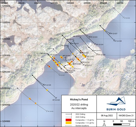
Figure 1: Plan map of diamond drill hole traces around the Hickey's Pond showing
To view an enhanced version of this graphic, please visit:
https://images.newsfilecorp.com/files/8769/137757_cd662dcd7411aaa4_001full.jpg
Mapping and sampling program
Mapping and geochemical sampling programs were completed on numerous undrilled prospects throughout the property. A total of 83 new rock chip samples were collected over 11 prospects, with results pending. Geological and alteration mapping was completed over the prospects and has outlined zones of advanced argillic alteration typical of high-sulphidation epithermal systems on most of these prospects. The results from this work will help guide future exploration programs and rank existing targets for drill testing.
The prospects targeted in this mapping and sampling program included Bullwinkle and Strange; two historical showings approximately 2 km apart along the regional strike. At Bullwinkle, the alteration system is at least 200 m in width and 950 m in length. Two prominent parallel ridges of advanced argillic alteration are coincident with a gold-in-soil geochemical anomaly, anomalous gold in basal till samples as well as biogeochemical anomalism. At Strange, a small outcrop sampled historically returned 3.3 g/t Au in rock chip sample. The outcrop at Strange is on strike with the alteration at Bullwinkle and no outcrop exists between the two showings. The current work program will help vector future exploration drilling at both these and the other targets under investigation.
Assay results for Tower showing drill program
The Tower showing, located approximately 11 km to the southwest of Hickey's Pond was selected for initial drill testing because it was logistically simple to drill in the time available following the Hickey's Pond drill program. A plan map showing drill collars and traces for drill holes completed at Tower to date is given in Figure 4. A total of 1,845 m of diamond drilling in nine holes have tested the Tower system over 850 m of strike length.
Assay results have been received for the holes completed at Tower and a table of results is given in Table 2. Several holes intersected anomalous gold mineralisation, and the footprint of the alteration system has been confirmed to be open in all directions, however, the drilling to date has not intercept any intervals with composite grades of over 1 g/t Au. All holes have intercepted epithermal alteration consistent with current geological models for these types of epithermal systems. Quartz-alunite schists, quartz breccias and quartz-hematite breccias have been intercepted across the entire length of the system which is open along strike and to depth.
Table 2: Composited gold intercepts for all drillholes completed at the Tower showing. Insufficient drilling has been completed to estimate true thicknesses.
| Hole |
From |
To |
Length (m) |
Au (g/t) |
| TW-22-001 |
40.00 |
51.00 |
11.00 |
0.22 |
| TW-22-002 |
78.50 |
97.20 |
18.70 |
0.18 |
| TW-22-003 |
148.00 |
176.00 |
28.00 |
0.14 |
| TW-22-004 |
104.00 |
105.10 |
1.10 |
0.33 |
| TW-22-005 |
46.50 |
47.50 |
1.00 |
0.11 |
| TW-22-006 |
120.60 |
121.60 |
1.00 |
0.23 |
| TW-22-007 |
No significant intercepts |
| TW-22-008 |
No significant intercepts |
| TW-22-009 |
176.30 |
185.00 |
8.70 |
0.21 |

Figure 4: Plan map of diamond drill hole traces around the Tower showing
To view an enhanced version of this graphic, please visit:
https://images.newsfilecorp.com/files/8769/137757_cd662dcd7411aaa4_002full.jpg
Sampling, quality assurance & quality control
NQ-sized core samples with nominal lengths of 1.0 m were sawed longitudinally in half. Half-core samples were collected for assay, and the remaining half-core returned to the core box. Appropriate geochemical standards spanning a range of gold concentrations (OREAS North America Inc.), geochemical blanks (locally sourced granite), as well as sample duplicates were introduced into the sample stream following industry best practice guidelines. Core samples were delivered by Company personnel to Eastern Analytical Ltd., Springdale NL, for gold fire assay analysis. The entire sample is crushed, an appropriate subsample pulverised, and a 30 g gold fire assay with atomic absorption instrumental finish performed.
Drill hole collar information
Table 3: Hole collar location data. Positional data is given in UTM zone 21 projection, NAD83 horizontal datum, and CGVD28 HTv2.0 vertical datum. Azimuths are given in degrees relative to UTM north, and inclination in degrees.
| Drill hole |
Northing |
Easting |
Elevation (m) |
Length (m) |
Azimuth (°) |
Inclination (°) |
| HP-22-030 |
5295306.1 |
699263.6 |
162.0 |
284.0 |
135 |
-45 |
| TW-22-001 |
5286517.4 |
692671.4 |
159.4 |
147.0 |
135 |
-45 |
| TW-22-002 |
5286530.8 |
692658.2 |
158.9 |
209.0 |
135 |
-45 |
| TW-22-003 |
5286565.3 |
692618.8 |
157.1 |
201.0 |
135 |
-70 |
| TW-22-004 |
5286405.2 |
692429.7 |
159.0 |
192.0 |
135 |
-60 |
| TW-22-005 |
5286378.4 |
682485.0 |
159.5 |
101.0 |
133 |
-45 |
| TW-22-006 |
5286437.7 |
682394.7 |
162.1 |
263.0 |
135 |
-65 |
| TW-22-007 |
5286288.9 |
692204.1 |
179.35 |
221.0 |
135 |
-45 |
| TW-22-008 |
5286130.7 |
692045.5 |
173.9 |
269.0 |
135 |
-45 |
| TW-22-009 |
5286687.8 |
592674.3 |
150.2 |
242.0 |
135 |
-45 |
About Burin Gold Corp.
Burin Gold is a recently listed public company on the TSX Venture Exchange (TSXV: BURG). The Company's principal asset is its Hickey's Pond-Paradise Gold Project on the Burin Peninsula, Newfoundland. This project contains the Hickey's Pond gold prospect, drill tested with an initial 1,000 m drill program in 2020 with best results of 10.8 m of 4.43 g/t Au, as well as numerous other historical high-sulphidation epithermal gold showings that have yet to be drill tested.
Qualified Person
David Clark, MSc, PGeo, CEO of Burin Gold, is the Company's designated Qualified Person within the meaning of National Instrument 43-101 Standards of Disclosure for Mineral Projects ("NI 43-101"). He has prepared the technical content of this news release.
Acknowledgement
The Company acknowledges the financial assistance of the Mineral Development Division, Department of Industry, Energy, and Technology, Government of Newfoundland & Labrador, via its Junior Exploration Assistance Program. The program provides valuable financial rebates on exploration expenditures made in the province to qualifying exploration companies. The Company has benefited from the program yearly since 2018.
On behalf of the Board
"David Clark"
CEO & Director
Further Information:
David Clark
CEO & Director
Burin Gold Corp.
1-877-620-4185 - toll free
info@burin-gold.com
Forward-Looking Statements
Neither TSX Venture Exchange nor its Regulation Services Provider (as that term is defined in the policies of the TSX Venture Exchange) accepts responsibility for the adequacy or accuracy of this release.
This News Release includes certain "forward-looking statements" which are not comprised of historical facts. Forward-looking statements include estimates and statements that describe the Company's future plans, objectives or goals, including words to the effect that the Company or management expects a stated condition or result to occur. Forward-looking statements may be identified by such terms as "believes", "anticipates", "expects", "estimates", "may", "could", "would", "will", or "plan". Since forward-looking statements are based on assumptions and address future events and conditions, by their very nature they involve inherent risks and uncertainties. Although these statements are based on information currently available to the Company, the Company provides no assurance that actual results will meet management's expectations. Risks, uncertainties and other factors involved with forward-looking information could cause actual events, results, performance, prospects and opportunities to differ materially from those expressed or implied by such forward-looking information. Forward-looking information in this news release includes, but is not limited to, the Company's objectives, goals or future plans, statements, exploration results, potential mineralization, the estimation of mineral resources, exploration and mine development plans, timing of the commencement of operations and estimates of market conditions. Factors that could cause actual results to differ materially from such forward-looking information include, but are not limited to failure to identify mineral resources, failure to convert estimated mineral resources to reserves, the inability to complete a feasibility study which recommends a production decision, the preliminary nature of metallurgical test results, delays in obtaining or failures to obtain required governmental, environmental or other project approvals, political risks, inability to fulfill the duty to accommodate First Nations and other indigenous peoples, uncertainties relating to the availability and costs of financing needed in the future, changes in equity markets, inflation, changes in exchange rates, fluctuations in commodity prices, delays in the development of projects, capital and operating costs varying significantly from estimates and the other risks involved in the mineral exploration and development industry, an inability to predict and counteract the effects of COVID-19 on the business of the Company, including but not limited to the effects of COVID-19 on the price of commodities, capital market conditions, restriction on labour and international travel and supply chains, and those risks set out in the Company's public documents filed on SEDAR. Although the Company believes that the assumptions and factors used in preparing the forward-looking information in this news release are reasonable, undue reliance should not be placed on such information, which only applies as of the date of this news release, and no assurance can be given that such events will occur in the disclosed time frames or at all. The Company disclaims any intention or obligation to update or revise any forward-looking information, whether as a result of new information, future events or otherwise, other than as required by law.
To view the source version of this press release, please visit https://www.newsfilecorp.com/release/137757
