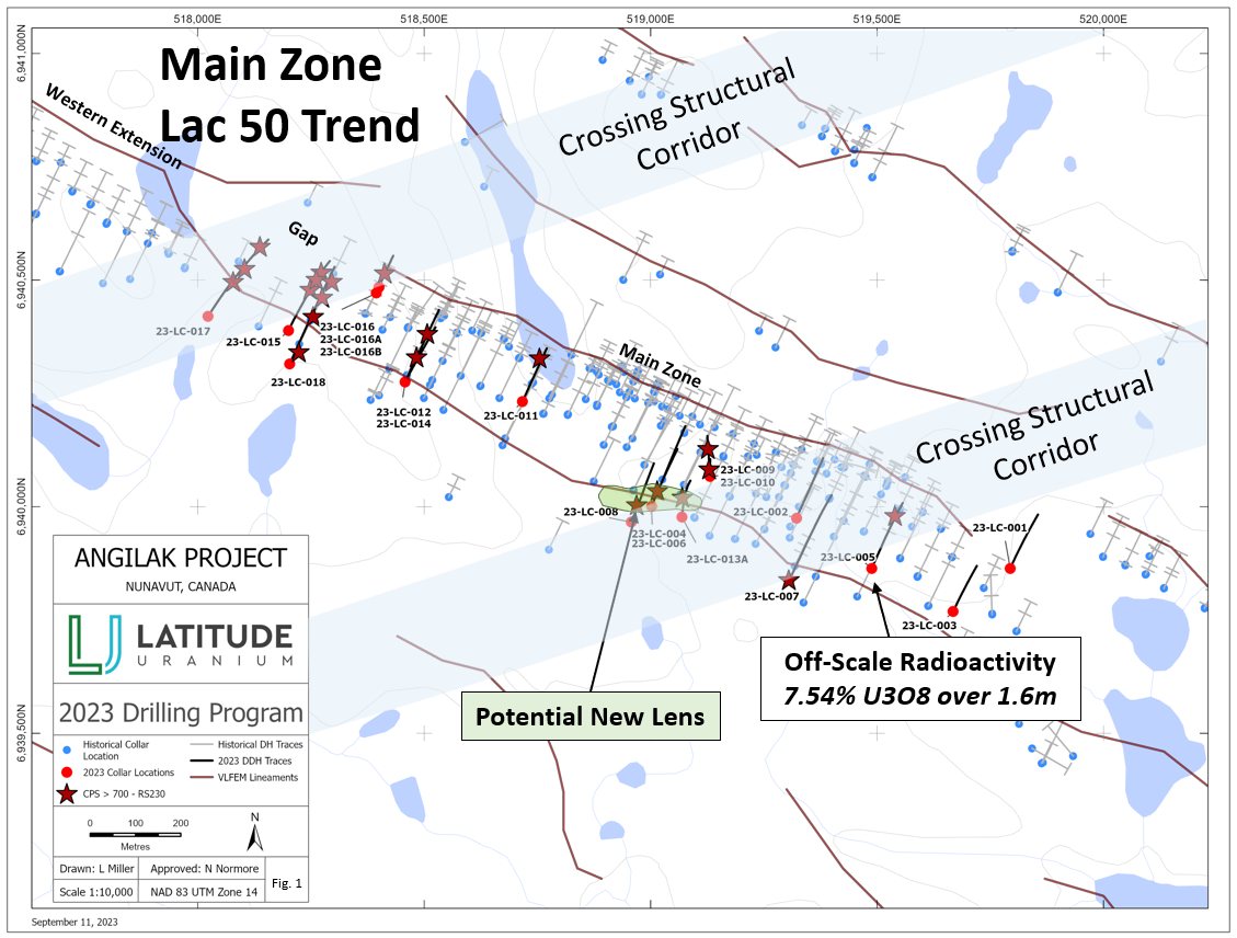
TORONTO, Dec. 04, 2023 (GLOBE NEWSWIRE) -- Latitude Uranium Inc. (“Latitude Uranium”, “LUR” or the “Company”) (CSE: LUR, OTCQB: LURAF, FRA: EI1) is pleased to announce the second and final batch of assay results from its 2023 drill program at the Angilak Project in Nunavut, Canada (“Angilak”). This final batch of assays contains eight holes and follows the first batch announced on November 7, 2023, for a total of 18 holes (5,665 meters) focused on the Main Zone of the Lac 50 Trend (Figure 1).
Highlights:
- Consists of holes 12-18, plus hole 4 which was pending from the first batch (See Table 1 for assay results).
- Known mineralization has been further extended, including hole 15 which returned 2.88% U3O8 over 0.5m and 2.05% U3O8 over 0.5m.
- New potential lens and associated hanging wall mineralization has been further extended in multiple holes.
- 2024 goals remain intact, to have a robust drill program and to provide a compliant current mineral resource estimate at the end of the year to replace the historical inferred mineral resource of 43.3 million lbs U3O8 at 0.69% grade1.
John Jentz, CEO of LUR, commented, “The 2023 Angilak drill program was successful on many fronts with this last batch of assays confirming our previous thoughts on the overall success. It is clear from multiple cross-sections that the known mineralization has been extended. The best example was hole 5, located at the edge of a cross-cutting east-northeasterly structure, which returned 7.54% U3O8 over 1.6m, infilling a 100m gap in historical drilling and indicating robust down-dip continuity. A new potential lens was discovered, increasing the known mineralization and adding to the potential for further expansion. Additional geologic knowledge was obtained, including the importance of cross-cutting structures and tuff lenses. These findings will be synthesized over the winter months into a cohesive 2024 drill program for Angilak. Our 2024 goals remain intact, to have a robust drill program and to provide stakeholders with a compliant mineral resource estimate at the end of the year.”
Figure 1: 2023 Drill Program – 18 holes completed in the Main Zone of the Lac 50 Trend
2023 Angilak Assay Results – Second and Final Batch
Assay results for the second and final batch are presented in Table 1 below. Results for the last batch of eight assays (Table 1 shows holes 4, 12-18) are from the west side of the Main Zone on the Lac 50 Trend. The overall 2023 drill program focused on extending known historical intercepts within the historical inferred mineral resource of 43.3m lbs U3O8 at 0.69% grade1 and testing geological interpretations to discover new mineralized areas.
Holes 4 and 13 – New Lens and the Importance of Cross-Cutting Structures
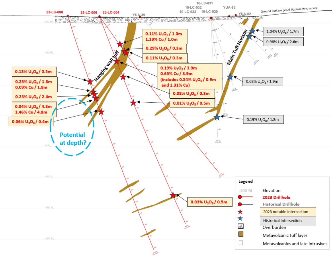
Hole 4 (23-LC-004) was designed to test the hanging wall in the new potential lens up dip from holes 6 and 8 (previously reported on November 7, 2023). Hole 4 is located within an east-northeasterly cross-cutting structural corridor and returned multiple mineralized intercepts, the best being 0.29% U3O8 over 0.3m from 69.8 to 70.1m, with copper mineralization also present in the system with grades of up to 1.19% Cu over 1.0m from 56.8 to 57.8m. In viewing the three drillholes (4, 6 and 8) on this section together in Figure 2, it is apparent that mineralization within the hanging wall lens is broadening with depth and, subject to further geological interpretation, will be a central part of the 2024 drill campaign.
Figure 2: Cross Section of holes 4, 6, 8
Holes 4 and 13 – New Lens and the Importance of Cross-Cutting Structures (cont’d)
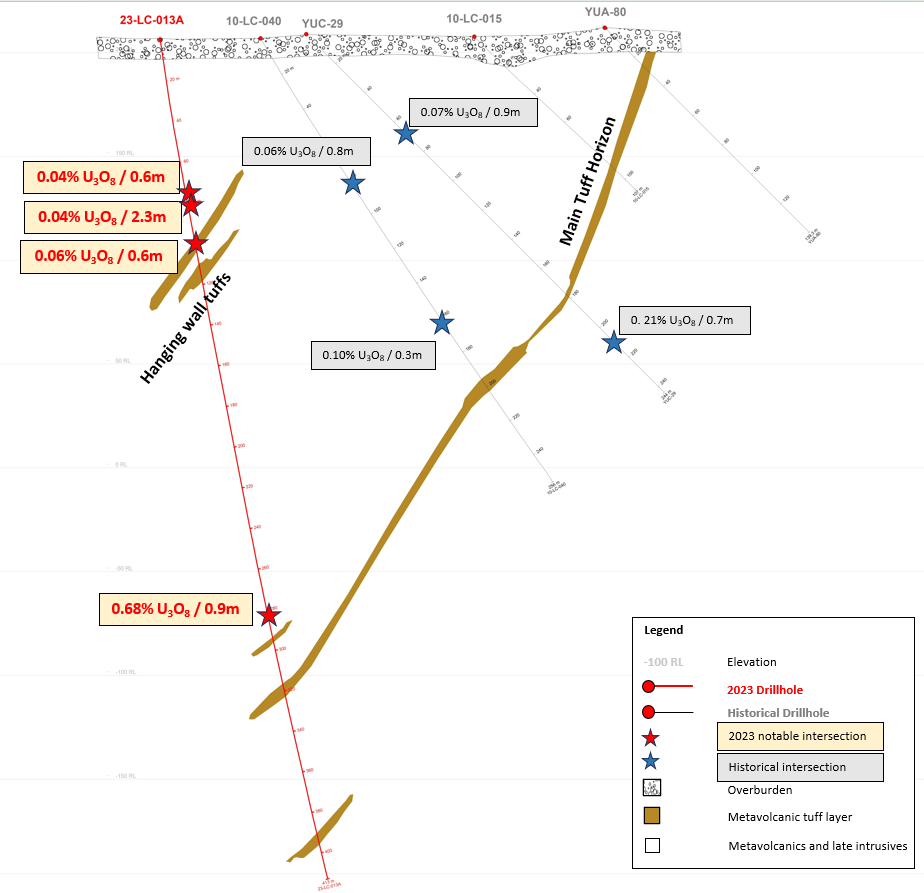
Hole 13 (23-LC-013) is located slightly east of hole 4, but still within the east-northeasterly cross-cutting structural corridor. The purpose of hole 13 was to test more of the structural corridor in addition to tuffaceous horizons. As seen in Figure 3, hole 13 intercepted 0.68% U3O8 over 0.9m from 282.9 to 283.8m showing continuity of the main tuff horizon at depth. Additionally, hole 13 returned multiple shallow intersections in the shallower hanging wall.
Results from these drillholes offer further evidence of a correlation between intersections of tuffaceous units in the hanging wall with east-northeasterly crossing structures and the extension of mineralization into the hanging wall of the Lac 50 Deposit. Both the hanging wall tuff lens and the extension of the crosscutting structure into the hanging wall of the Lac 50 Trend are targets which have developed and advanced out of the 2023 drilling program. This valuable knowledge will be incorporated into the 2024 drill campaign.
Figure 3: Cross Section of hole 13
Holes 12, 14, 15 and 18 – Testing Continuity in the Hanging Wall and Main Tuff
Holes 12, 14, 15, and 18 (23-LC-012, 23-LC-014, 23-LC-015 and 23-LC-018) were designed to test for Lac 50 Trend mineralization at depth while additionally testing for shallower hanging wall mineralization. The holes were designed as up-dip/down-dip pairs to test shallow and deep in the system along the western end of the Main Zone on the Lac 50 Trend.
Holes 12 and 14 – Continuity in Hanging Wall and Main Tuff Horizon
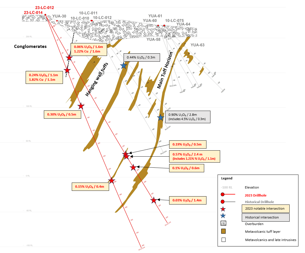
Holes 12 and 14 were drilled as a fan with hole 12 being drilled at a shallower angle. As seen in Figure 4, there were multiple intersections at depth in the main tuff horizon, the best was 1.21% U3O8 and 0.40% Cu over 1.1m within a broader mineralized zone of 0.57% U3O8 and 0.22% Cu over 2.4m from 234.6 to 237.0m. Additionally, there were multiple intersections in the hanging wall, including 0.30% U3O8 over 0.5m from 139.9 to 140.4m and 0.24% U3O8 and 1.82% Cu over 1.1m from 82.8 to 83.9m.
Figure 4: Cross Section of holes 12 and 14
Holes 12 and 14 – Fault Extension and Conglomerates are Future Exploration Targets
Significantly, the shallowest intervals in holes 12 and 14 containing the highest grades of copper and associated U3O8 are associated with a fault zone at the base of a mappable conglomeritic unit. This unit extends to the southeast where it is associated with a strong surface radiometric response. The faults are interpreted to represent basin bounding structures with a potentially protracted period of activity and associated mineralization bearing fluid flow. The extension of these faults and the conglomerates represent significant additional targets for future exploration.
Holes 15 and 18 – Continuity in Hanging Wall and Main Tuff Horizon
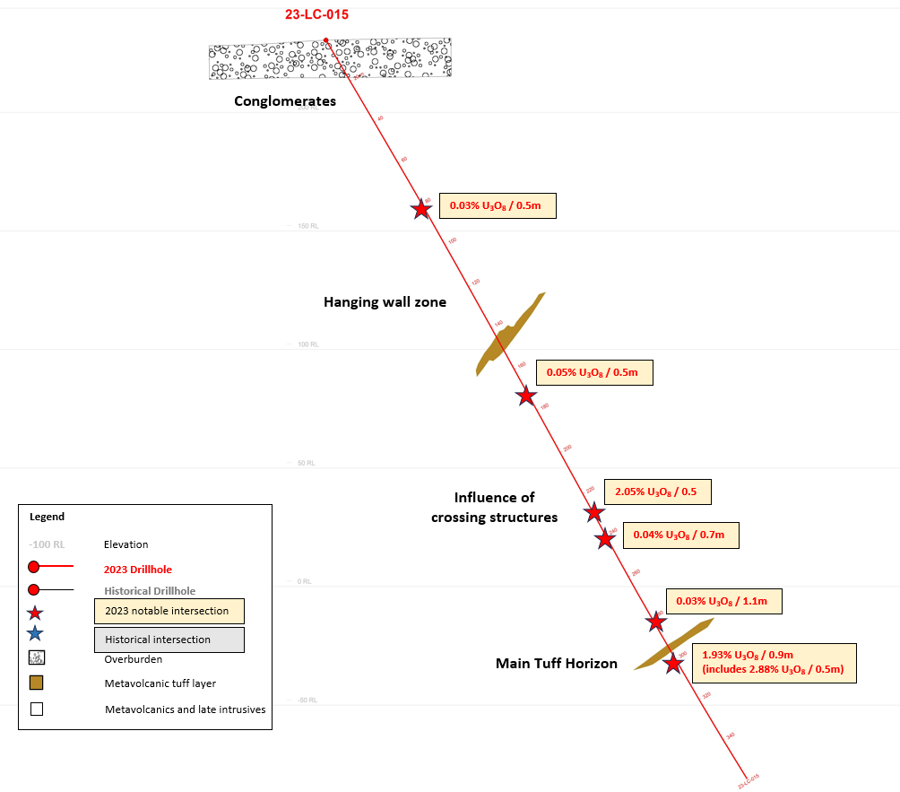
Holes 15 and 18 were drilled on an offset rather than a fan with hole 15 being drilled approximately 72m to the northwest of hole 18, both at -60 degrees. Assays returned numerous at depth results, including 2.88% U3O8 over 0.5m from 299.1 to 299.6m as well as 2.05% U3O8 over 0.5m from 229.8 to 230.3m (Figure 5). Additionally, there were multiple intersections in the shallower hanging wall and conglomerates, including 0.29% U3O8 and 2.12% Cu over 0.5m, within 0.12% U3O8 and 1.04% Cu over 2.0m from 34.0 to 36.0m.
Both holes 15 and 18 intersected the shallow conglomerate identified in holes 12 and 14 and surface mapping. Although not associated with obvious faulting as in the holes 12 and 14, the contact is associated with strong U3O8 and Cu mineralization in hole 18 (34.0 to 36.0m).
Figure 5: Cross Section of hole 15 including 2.88% U3O8 over 0.5m and 2.05% U3O8 over 0.5m
2023 Summary and 2024 Plans
The 2023 drilling program consisted of a total of 18 holes (5,665 meters) focused on the Main Zone of the Lac 50 Trend (Figure 1). The 2023 program was successful in achieving its objective of extending known mineralization, and was also successful in testing several targets and concepts including:
Extending Known Mineralization – Main Tuff Horizon
The Main Zone of the Lac 50 Trend represents one of four zones of the historical mineral resource on the Angilak Property and as such, we believe represents an excellent target for the extension of known mineralization on strike and at depth. The 2023 program showed that the main tuff horizon remains open at depth, specifically near the intersection with major east-northeasterly crossing structures. The best example was hole 5, located at the edge of a cross-cutting east-northeasterly structure, which returned 7.54% U3O8 over 1.6m infilling a 100m gap in historical drilling and indicating robust down-dip continuity.
New Potential Lens, New Potential Hanging Wall Implications
In addition to the main tuff horizon, geophysical and radiometric evidence alluded to the existence of favourable tuffaceous horizons in the hanging wall of the Lac 50 Trend. A fan of holes 4, 6 and 8 was designed to test one of these horizons. The results were positive, showing these horizons represent viable exploration targets, specifically where intersected by crossing structures. The potential new lens identified by holes 4, 6 and 8 has multiple implications, including: i) extending the new potential lens at depth; ii) adding additional mineralization to the Lac 50 Trend; iii) examining the potential for future hanging wall expansion in other areas of the Lac 50 Trend; and iv) potentially reducing waste rock in an open pit mining scenario.
Importance of Crossing Structures
The Lac 50 Trend is transected by east-northeasterly structures which are evident in geophysical surveys and geological modelling. The 2023 drilling program highlighted the significance of these crossing structures as U3O8 and Cu mineralization within tuffaceous horizons tends to increase with proximity to these structures. There are several regional exploration targets, like Blaze and Pulse, which are in direct alignment with these crossing structures.
Conclusion
The 2023 Angilak drill program was successful on many fronts. It is clear from multiple cross-sections that the known mineralization has been extended. A new potential lens has been discovered, increasing the known mineralization, and adding to the geological knowledge and potential for further expansion. Additional geologic knowledge has been obtained and will be synthesized over the winter months into a robust 2024 drill program at Angilak.
| Table 1: Last Batch Results from Latitude Uranium’s 2023 Drill Program at Angilak |
Drillhole
|
From |
To |
Length |
U3O8 wt % |
Cu % (Calculated)
|
| (meters) |
(meters) |
(meters) |
(Assay) |
| 23-LC-004 |
56.8 |
57.8 |
1 |
0.11 |
1.19 |
| Easting: 519002.3 |
58.7 |
59.2 |
0.5 |
0.03 |
0.24 |
| Northing: 6939999.0 |
59.5 |
60.9 |
1.4 |
0.04 |
0.04 |
| Elev: 210.8 m |
62.0 |
62.5 |
0.5 |
0.02 |
0.00 |
| Az: 24, Dip: -55 |
64.3 |
64.8 |
0.5 |
0.06 |
0.01 |
| EOH: 317.0 m |
65.3 |
66.0 |
0.7 |
0.02 |
0.00 |
|
67.3 |
67.8 |
0.5 |
0.07 |
0.05 |
|
68.3 |
68.8 |
0.5 |
0.05 |
0.01 |
|
69.8 |
70.1 |
0.3 |
0.29 |
0.02 |
|
71.6 |
71.9 |
0.3 |
0.11 |
0.02 |
|
73.9 |
74.5 |
0.6 |
0.02 |
0.04 |
|
78.5 |
79.0 |
0.5 |
0.03 |
0.02 |
|
83.3 |
83.7 |
0.4 |
0.03 |
0.00 |
| 23-LC-012 |
72.8 |
74.4 |
1.6 |
0.06 |
1.22 |
| Easting: 518458.1 |
102.2 |
102.5 |
0.3 |
0.06 |
0.03 |
| Northing: 6940273.5 |
113.0 |
113.5 |
0.5 |
0.06 |
0.10 |
| Elev: 233.5 m |
130.0 |
130.7 |
0.7 |
0.02 |
0.01 |
| Az: 26, Dip: -60 |
232.0 |
232.5 |
0.5 |
0.19 |
0.04 |
| EOH: 347.0 m |
234.6 |
237.0 |
2.4 |
0.57 |
0.22 |
|
Includes |
|
|
|
|
|
234.6 |
235.7 |
1.1 |
1.21 |
0.40 |
|
255.1 |
255.7 |
0.6 |
0.10 |
0.01 |
|
264.6 |
265.1 |
0.5 |
0.02 |
0.15 |
|
282.8 |
283.3 |
0.5 |
0.04 |
0.00 |
|
308.5 |
309.9 |
1.4 |
0.03 |
0.03 |
| 23-LC-013A |
59.1 |
59.9 |
0.8 |
0.02 |
0.02 |
| Easting: 519064.3 |
76.6 |
77.2 |
0.6 |
0.04 |
0.03 |
| Northing: 6939973.8 |
77.6 |
78.0 |
0.4 |
0.03 |
0.01 |
| Elev: 206.4 m |
80.1 |
82.4 |
2.3 |
0.04 |
0.04 |
| Az: 12, Dip: -80.5 |
83.4 |
85.0 |
1.6 |
0.03 |
0.02 |
| EOH: 413.0 m |
98.8 |
99.4 |
0.6 |
0.06 |
0.16 |
|
282.9 |
283.8 |
0.9 |
0.68 |
0.00 |
| 23-LC-014 |
82.8 |
83.9 |
1.1 |
0.24 |
1.82 |
| Easting: 518458.3 |
89.2 |
90.3 |
1.1 |
0.11 |
0.12 |
| Northing: 6940273.9 |
138.1 |
139.4 |
1.3 |
0.02 |
0.08 |
| Elev: 233.3 m |
139.9 |
140.4 |
0.5 |
0.30 |
0.02 |
| Az: 25, Dip: -70 |
258.5 |
258.9 |
0.4 |
0.15 |
0.02 |
| EOH: 362 m |
288.4 |
288.7 |
0.3 |
0.08 |
0.02 |
|
347.4 |
347.9 |
0.5 |
0.01 |
0.01 |
| 23-LC-015 |
81.6 |
82.1 |
0.5 |
0.03 |
0.03 |
| Easting: 518202.0 |
170.5 |
171.0 |
0.5 |
0.05 |
0.11 |
| Northing: 6940390.5 |
220.1 |
220.6 |
0.5 |
0.02 |
0.01 |
| Elev: 230.5 m |
229.8 |
230.3 |
0.5 |
2.05 |
0.07 |
| Az: 28, Dip: -60 |
240.8 |
241.5 |
0.7 |
0.04 |
0.03 |
| EOH: 359.0 m |
274.4 |
274.7 |
0.3 |
0.05 |
0.01 |
|
280.5 |
281.1 |
0.6 |
0.03 |
0.01 |
|
281.6 |
282.7 |
1.1 |
0.03 |
0.02 |
|
295.0 |
295.8 |
0.8 |
0.05 |
0.00 |
|
299.1 |
300.0 |
0.9 |
1.93 |
0.03 |
|
Includes |
|
|
|
|
|
299.1 |
299.6 |
0.5 |
2.88 |
0.02 |
|
342.1 |
342.4 |
0.3 |
0.02 |
0.01 |
| 23-LC-016B |
24.8 |
25.3 |
0.5 |
0.27 |
0.14 |
| Easting: 518401.6 |
|
|
|
|
|
| Northing: 6940485.8 |
|
|
|
|
|
| Elev: 230.1 m |
|
|
|
|
|
| Az: 24, Dip: -60 |
|
|
|
|
|
| EOH: 143.0 m |
|
|
|
|
|
| 23-LC-017 |
152.6 |
153.6 |
1.0 |
0.01 |
0.01 |
| Easting: 518024.4 |
198.0 |
200.0 |
2.0 |
0.02 |
0.01 |
| Northing: 6940421.3 |
|
|
|
|
|
| Elev: 234.9 m |
|
|
|
|
|
| Az: 35, Dip: -45 |
|
|
|
|
|
| EOH: 302.0 m |
|
|
|
|
|
| 23-LC-018 |
34.0 |
36.0 |
2.0 |
0.12 |
1.04 |
| Easting: 518205.8 |
Includes |
|
|
|
|
| Northing: 6940320.3 |
34.5 |
35.0 |
0.5 |
0.29 |
2.12 |
| Elev: 229.8 |
112.8 |
113.3 |
0.5 |
0.08 |
0.04 |
| Az: 26, Dip: -60 |
213.0 |
213.6 |
0.6 |
0.29 |
0.01 |
| EOH: 444.0 m |
252.5 |
253.3 |
0.8 |
0.03 |
0.01 |
|
262.0 |
262.6 |
0.6 |
0.02 |
0.01 |
|
270.2 |
271.1 |
0.9 |
0.04 |
0.04 |
|
300.6 |
301.3 |
0.7 |
0.02 |
0.01 |
|
317.3 |
319.4 |
2.1 |
0.02 |
0.01 |
|
324.2 |
325.7 |
1.5 |
0.04 |
0.01 |
|
333.2 |
334.0 |
0.8 |
0.03 |
0.02 |
|
346.3 |
347.0 |
0.7 |
0.05 |
0.02 |
|
348.0 |
348.6 |
0.6 |
0.02 |
0.01 |
|
352.8 |
353.7 |
0.9 |
0.11 |
0.01 |
|
360.0 |
360.8 |
0.8 |
0.06 |
0.01 |
|
364.4 |
365.1 |
0.7 |
0.05 |
0.01 |
|
388.6 |
389.3 |
0.7 |
0.02 |
0.01 |
|
395.2 |
395.8 |
0.6 |
0.03 |
0.02 |
|
398.6 |
399.8 |
1.2 |
0.02 |
0.01 |
|
404.2 |
406.8 |
2.6 |
0.08 |
0.01 |
|
411.2 |
412.0 |
0.8 |
0.01 |
0.01 |
|
416.0 |
416.7 |
0.7 |
0.03 |
0.01 |
|
|
|
|
|
|
1. See Figure 1 for drillhole locations.
2. Samples were sent to the Saskatchewan Research Council (SRC) lab and facilities for U3O8 geochemical analysis. The SRC is an ISO/IEC 17025/2005 and Standards Council of Canada certified analytical independent laboratory. Samples returning 100 ppm U or greater were analyzed for wt % U3O8.
3. Where consecutive samples are above 0.02% U3O8, intersections are weighted averages of composited samples.
4. All reported depths and intervals are drill hole depths and intervals unless otherwise noted, and do not represent true thicknesses, which have yet to be determined.
Notes on the Historical Mineral Resource Estimate for the Angilak Project:
- This estimate is considered to be a “historical estimate” under NI 43-101 and is not considered by Latitude Uranium to be current. See below for further details regarding the historical mineral resource estimate for the Angilak Property.
- Mineral resources which are not mineral reserves do not have demonstrated economic viability.
- The estimate of mineral resources may be materially affected by geology, environment, permitting, legal, title, taxation, sociopolitical, marketing or other relevant issues.
- The quality and grade of the reported inferred resource in this estimation are uncertain in nature and there has been insufficient exploration to define these inferred resources as an indicated or measured mineral resource, and it is uncertain if further exploration will result in upgrading them to an indicated or measured resource category.
- Contained value metals may not add due to rounding.
- A 0.2% U3O8 cut-off was used.
- The mineral resource estimate contained in this press release is considered to be “historical estimates” as defined under NI 43-101 and is not considered by LUR to be current.
- Reported by ValOre Metals Corp. in a Technical Report entitled “Technical Report and Resource Update For The Angilak Property, Kivalliq Region, Nunavut, Canada”, prepared by Michael Dufresne, M.Sc., P.Geol. of APEX Geosciences, Robert Sim, B.Sc., P.Geo. of SIM Geological Inc. and Bruce Davis, Ph.D., FAusIMM of BD Resource Consulting Inc., dated March 1, 2013.
- As disclosed in the above noted technical report, the historic estimate was prepared under the direction of Robert Sim, P.Geo, with the assistance of Dr. Bruce Davis, FAusIMM, and consists of three-dimensional block models based on geostatistical applications using commercial mine planning software. The project limits area based in the UTM coordinate system (NAD83 Zone14) using nominal block sizes measuring 5x5x5m at Lac Cinquante and 5x3x3 m (LxWxH) at J4. Grade (assay) and geological information is derived from work conducted by Kivalliq during the 2009, 2010, 2011 and 2012 field seasons. A thorough review of all the 2013 resource information and drill data by a Qualified Person , along with the incorporation of subsequent exploration work and results, which includes some drilling around the edges of the historical resource subsequent to the publication of the 2013 technical report, would be required in order to verify the Angilak Property historical estimate as a current mineral resource.
- The historical mineral resource estimate was calculated in accordance with NI 43-101 and CIM standards at the time of publication and predates the current CIM Definition Standards for Mineral Resources and Mineral Reserves (May, 2014) and CIM Estimation of Mineral Resources & Mineral Reserves Best Practices Guidelines (November, 2019).
Quality Assurance/Quality Control – Geochemical Sampling Procedures
All drill core samples from the 2023 summer program were shipped to Saskatchewan Research Council Geoanalytical Laboratories (SRC), an independent lab in Saskatoon, Saskatchewan, in secure containment for preparation, processing, and multi-element analysis by ICP-MS and ICP-OES Basement Exploration Package using partial digestion (HNO3/HCl) and total digestion (HF/HNO3/HClO4), and U3O8 wt % assay by ICP-OES. The SRC is an ISO/IEC 17025/2005 and Standards Council of Canada certified analytical laboratory.
Assay samples comprise 0.2 – 1.2-meter continuous split-core (half) samples based on radioactive intervals (in counts per second (cps)) measured in field using a calibrated handheld spectrometer (RS230). During logging, cps is recorded as 10 cm intervals through the radioactive zone and 1.0 – 2.0m above and below into background radioactive core. This is performed when any measurements are above approximately 200 cps. Data is measured and recorded by a trained geotechnician and verified by the onsite supervising geologist.
Blanks, standard reference materials, and repeats are inserted into the sample stream at regular intervals by LUR and the SRC in accordance with LUR quality assurance/quality control (QA/QC) procedures. Geochemical assay data are subject to verification procedures by qualified persons employed by LUR prior to disclosure.
All reported depths and intervals are drill hole depths and intervals, unless otherwise noted, and do not represent true thicknesses, which have yet to be determined.
Qualified Person (QP)
The scientific and technical information in this news release has been reviewed and approved by Nancy Normore, M.Sc., P.Geo, the Vice President of Exploration of Latitude Uranium, who is a “Qualified Person” (as defined in NI 43-101).
About Latitude Uranium Inc.
Latitude Uranium is exploring and developing two district-scale uranium projects in Canada. Our primary focus is expanding the resource base at Angilak, which ranks amongst the highest-grade uranium deposits globally, outside of the Athabasca. Additionally, we are advancing the CMB Project, situated in the prolific Central Mineral Belt in central Labrador adjacent to the Michelin Deposit, with numerous occurrences of uranium, copper and potential IOCG style mineralization.
For More Information, Please Contact:
Latitude Uranium Inc.
John Jentz
CEO
jjentz@latitudeuranium.com
Toll-Free: 1-833-572-2333
Email: info@latitudeuranium.com
Website: www.latitudeuranium.com
Twitter: @LatitudeUr_
LinkedIn: https://www.linkedin.com/company/latitude-uranium-inc/
Cautionary Statement Regarding “Forward-Looking” Information
This news release contains “forward-looking information” within the meaning of applicable Canadian securities laws.“Forward-looking information” includes, but is not limited to, statements with respect to activities, events or developments that the Company expects or anticipates will or may occur in the future including, but not limited to, the 2024 drill program and the Company’s planned exploration focus for 2024; the planned publication of a mineral resource estimate; the Company’s ongoing business plan, sampling, exploration and work programs. Generally, but not always, forward-looking information and statements can be identified by the use of words such as “plans”, “expects”, “is expected”, “budget”, “scheduled”, “estimates”, “forecasts”, “intends”, “anticipates”, or “believes” or the negative connotation thereof or variations of such words and phrases or statements that certain actions, events or results “may”, “could”, “would”, “might” or “will be taken”, “occur” or “be achieved” or the negative connotation thereof.
Forward-looking information and statements are based on our current expectations, beliefs, assumptions, estimates and forecasts about LUR’s business and the industry and markets in which it operates. Such forward information and statements are based on numerous assumptions, including among others, that general business and economic conditions will not change in a material adverse manner, that locations of historical mineral resources estimates could lead to new mineralization discoveries and potentially be verified as current mineral resource estimates, that financing will be available if and when needed and on reasonable terms to conduct further exploration and operational activities, and that third party contractors, equipment and supplies and governmental and other approvals required to conduct LUR’s planned exploration activities will be available on reasonable terms and in a timely manner. Although the assumptions made by LUR in providing forward-looking information or making forward-looking statements are considered reasonable by management at the time, there can be no assurance that such assumptions will prove to be accurate.
Forward-looking information and statements also involve known and unknown risks and uncertainties and other factors, which may cause actual results, performances and achievements of LUR to differ materially from any projections of results, performances and achievements of LUR expressed or implied by such forward-looking information or statements, including, among others: limited operating history, negative operating cash flow and dependence on third party financing, uncertainty of additional financing, delays or failure to obtain required permits and regulatory approvals, no known mineral resources/reserves, aboriginal title and consultation issues, reliance on key management and other personnel; potential downturns in economic conditions; availability of third party contractors; availability of equipment and supplies; failure of equipment to operate as anticipated; accidents, effects of weather and other natural phenomena and other risks associated with the mineral exploration industry; changes in laws and regulation, competition, and uninsurable risks, community relations, delays in obtaining governmental or other approvals and the risk factors with respect to LUR set out in LUR’s annual information form in respect of the year ended November 30, 2022 filed with the Canadian securities regulators and available under LUR’s profile on SEDAR+ at www.sedarplus.ca.
Although LUR has attempted to identify important factors that could cause actual actions, events or results to differ materially from those contained in the forward-looking information or implied by forward-looking information, there may be other factors that cause results not to be as anticipated, estimated or intended. There can be no assurance that forward-looking information and statements will prove to be accurate, as actual results and future events could differ materially from those anticipated, estimated or intended. Accordingly, readers should not place undue reliance on forward-looking statements or information. LUR undertakes no obligation to update or reissue forward-looking information as a result of new information or events except as required by applicable securities laws.
1 This estimate is considered to be a “historical estimate” under National Instrument 43-101 – Standards of Disclosure for Mineral Projects (“NI 43-101”) and is not considered by Latitude Uranium to be current. See below for further details regarding the historical mineral resource estimate for the Angilak Property.
Photos accompanying this announcement are available at:
https://www.globenewswire.com/NewsRoom/AttachmentNg/5c8b491a-e10a-45c2-a43b-26474439b6f4
https://www.globenewswire.com/NewsRoom/AttachmentNg/ac02cb28-2999-4066-b0b8-fcac48dc5cb8
https://www.globenewswire.com/NewsRoom/AttachmentNg/fe60983c-7b2d-4bfd-bc03-5c6e9f76c6b3
https://www.globenewswire.com/NewsRoom/AttachmentNg/5e215775-2d98-42fe-9d06-6cdd7537e608
https://www.globenewswire.com/NewsRoom/AttachmentNg/5b29a561-3177-4c87-a0c0-71c9bd0c4ec3


