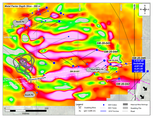
SM-20-046 SM - 20 - 046
Was drilled 200m east of - East west pit.
Slightly south on the horizontal.
Approx 500m east of - south pit - on the straight horizontal.
Why was this area never seeany follow up holes ?
- lol
https://ceo.ca/@GlobeNewswire/macdonald-mines-extends-the-scadding-gold-system-drills JULY 08 2020 22.40 m - 1.5 grams of gold.
Over 72 feet of gold @ 1.5 grams.
These are the type of holes that provide $$$ with every scoop.
NORTH PIT
has a potential connective to this - 20 - 046
How ?
North Pit is wide open, on top end of Bristol, and....
Is at a low elevation which this same elevation snakes it's way to - 20 - 046.
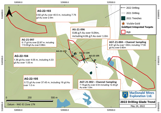
GLADE IS - 1 Km South of South Pit.
Which places Galde gold showings in connection to - 20 - 046.
Glade showings have similar intercepts as - 20 - 046.
0.72 grams gold - 37.45 m
5.17 grams gold - 22.67 m
0.82 grams gold - 40.5 m
0.86 grams gold - 9.04 m
NORTH PIT - gut - right down to hole - 20 046
to
SM 20 - 046 ( comnnective hole ) gut - continues down to Galde
to
GLADE
How is it connected ? Low lying land - that was - watershed.
It appears at glade - they're following the edge of a small range
So.... north pit to -
one hole and run away from - 20 -046 - which i feel is a strong connective - tie in.
to Glade.
Watershed from North Pit - outside of - outcrops.
Perfect place for breccia to build up and stack.
CONTRIBUTOR ?
Ashigami Lkae.
It too has an old watershed still seen in dotted smaller swamps or ponds that one can interlink on south shore road right down to glade. Which means... Ashigami is part of the system -
If one looks at google maps - you'll see how Ashigami's left horn ( west arm of lake ) flushed out
down into Glade.
North watershed passing - north pit - dumping gold.
Continuing on dumping more at - 20 - 046 location
Ashigami flushing out contributing with north watershed and aiming for - Glade.
--------------------------------------------------------------------------------------------------------------------------
Anomaly at Glade ?
two holes were sunk into higher terrain.
Which could mean, there's an additional gold system that runs to - Arcade - just north west of, Glade.
-------------------------------------------------------------------------------------------------------------------------
MAP BELOW -
See where the red star is located in upper right box ?
I'd like ot see a drill hole sunk - just a tad west of this star - in the gut...
If there's gold - with a deep intercept -
I'd say... my theory of north pit low land to 20 - 046 to glade would have a strong case.
And... would put things in perspective.
In a big way.
HERE'S THE RINGER HOLE
- 20 - 046 THAT COULD BE A MJAOR CONNECTIVE -
Now - open Google Maps - look for scaddign mine.
Jump from terrain to satalite images.
Draw your distances.
Look for the elevations... match the large intercepts with the lower elevations.
North pit - catches the watershed - North Pit is aside of hte Bristol, lowlands.
20 - 046 - same watershed as north pit - with addition of Ashigami watershed.
North pit and 20 - 046 - appear to tie into Glade.
Glade higher elevatio drill holes - just up and out of valley, could be gold system that pairs with Arcade -
Lot's of data to digest -
it'sa matter of sifting the presses - plotting it all out - on one map.
The junor should do this... for shareholders.
make a new map - i would say - 20 - 046 - is an important hole - connective hole.
We could have a decent gold sytem from north pit to - 20 - 046 - to glade ( valley watershed gold )
with a higher mound at glade which may connect to - Arcade.
That same higher elevation could be dumping goldinto the valley fro mlong ago.
Water ripping the lower part of Glades elevation and gold dropping out.
Cheers.....