GEOLOGY OF - SM 20 - 046WHAT TYPE OF ORE IS - SM - 20 - 046 ? The gold discovery in
SM-20-046 is hosted in the
Espanola limestone that was previously considered an unfavourable host for gold mineralization, and
below a breccia zone rich in pyrite mineralization with a polymetallic signature.
Chlorite alteration in that zone of gold mineralization is visually different from chlorite alteration encountered in the siliciclastic rocks of the Serpent formation elsewhere in the Scadding Deposit.
LINK -
https://ceo.ca/@GlobeNewswire/macdonald-mines-extends-the-scadding-gold-system-drills
SO.... drill hole SM 20 -046 -
is quite different than their typical siliciclastic rocks of the Scadd - Serpent formation.
was BMK lookingat the wrong type of - serpent rock at Scadd ?
Sounds like they were into just - silica chlorites - with some irons - around Scadd.
Espanola formation - is considered the serpent rock.
Green Limestone rock.
SM 20 - 046
Was in the limestone
and sulphide pyrite -
undestandable that caustic limestone would work the pyrites over cause a bleed or leach effect - and - if water added, couldalso result in - chloritized appearence of green - calcium limes do this.
What began to show up in the drills at - 20 - 046 ?
Copper - Nickel - PGE's.
With no follow up on other assays that were labeleld - TBD.
What happened after ?
Qunito - gets the urge to drink some water.
New Prez, steps in.
BMK - begins to work over Jovan.
BIG QUESTION ?
What do the cores look like at Glade ?
No core photos from - 20 - 046
No core pphotos that i know of from - Glade.
Top Secret.
Could Glade drills be in the - silty limesand pyrites - from the watershed path of, Ashigami ?
Ahhhhh.... this press release begins to reveal
Glade has some
Copper, Nickel, PGE...
MY HUNCH SAYS... looks awefully familiar to - 20 - 046
It must mean they're into more - pyrites if - other minerals are now showing up like, 20 046.
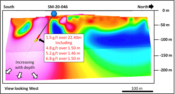
I took a screenshot from a retro video - of - 20 - 046 charability -
Have a look -
The pink zone in which 20 - 046 tapped into - is massive.
Where does it lead ?
Could this massive chargability lead to - Glade ?
I've only added where drill hole - SM 20 - 046 is located
And - an apprximation of Glade.
https://apis.mail.yahoo.com/ws/v3/mailboxes/@.id==VjN-5QiH52KGhJJafvgCjwmzVF72v8JvbmsrnIdTvAMeA9MSO1o-idfBnsll3s9AMp2LsVOAykft_OCWIB6Ledswcw/messages/@.id==AF7b6dAT3UBYY0ERBAkYIK_5jJ4/content/parts/@.id==2/thumbnail?appid=YMailNorrin HOW CAN WE KNOW FOR CERTAIN ? Simply check a google map to see if - Ashigami - old river shed - runs into Glade -
IT HAS A DIRECT HIT -
https://apis.mail.yahoo.com/ws/v3/mailboxes/@.id==VjN-5QiH52KGhJJafvgCjwmzVF72v8JvbmsrnIdTvAMeA9MSO1o-idfBnsll3s9AMp2LsVOAykft_OCWIB6Ledswcw/messages/@.id==AGDK5skrbMwyY0CxkweB4BD7OtA/content/parts/@.id==2/thumbnail?appid=YMailNorrin -----------------------------------------------------------------------------------------------------------------------------
ANYTHING ELSE ?
The original - drill placement charge map - for - 20 - 046 -
shows a drill line much further down - into the pinks.
It's a faint line -
My question is... did they drill further into the limestones at - 20 046 ?
Have a look - spot the thin faint line that extends -
 ANYTHING ELSE ?
 ( wink ) hey, it's better than a good movie - lol - ohhh... the drama.
I thought drill hole - AG - 22 103 - was superb. ( 0.82 GRAMS @ 40.5 meters )
Till i saw - AG - 22 - 105 - ( 0.72 grams @ 37.45 meters )
That's 100m apart and still hitting long intercepts.
Where are they... ?
In the channel gut of Asgigami's old - river bed.
But... if we revert back to - the pink charge map -
Are they drilling deep enough ?
This pink charge -the only one i agree with - runs really deep.
Could this Ashigami arm that dumpedout and made small lakes all along south shore and perhaps a far larger rivershed long ago - been a - FAULT ?
Or... just a watershedthat happened to bring in sigificant amounts of - tills - from up north
both north to south watersheds + Ashigami ?
We need core photos - to see what they're tapping into.
compare photos with - 20 046 vs Glade.
Whose right ? A I - with a western push - outcrops running east west.
Or.. is google maps correct - showing outcrops running north south - in terrain mode remving overburden ?
If they work over the dogleg at glade using google terrain maps like i did... the dogleg eventually moves to the south.
And... if they begin working their way towards - 20 046 - things could get interesting - if they keep
on the same intercepts -
But.. they should really tap at least one or two holesdeeper - to test the pink charge system.
Could be really good stuffdown deeper - perhaps more pyrites the good stuff - hosting nickel copper PGE's...
And.. i hope they take a second look at the - chlorite cores - especially cores that have lots of pyrites or arsenopyrites and albitite, chamolines -
Simple ... soak in HCL - more of the chloride - then... use electrolysis - to pull any nickel out
this would be far better - using a nickel electrolysis - thery'd know for certain if they have nickel chloirde -
Cheers....
That's all i'm researching -
If i've helped- good.
If not... oh well.