ORIGINAL: Canagold Continues to Intersect High-Grade Gold Mineralization in C-West Main Vein at New Polaris Project, BC
2022-02-24 07:30 ET - News Release
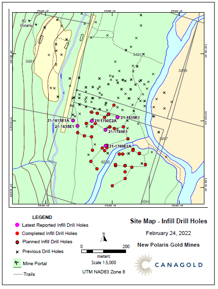
VANCOUVER, BC / ACCESSWIRE / February 24, 2022 / Canagold Resources Ltd. (TSX:CCM), (OTCQB:CRCUF), (FSE:CANA) announces high-grade gold assays for six more drill holes from the expanded drill program at its 100% owned New Polaris Gold project located in northwestern British Columbia, 100 kilometers (km) south of Atlin and 60 km northeast of Juneau, Alaska.
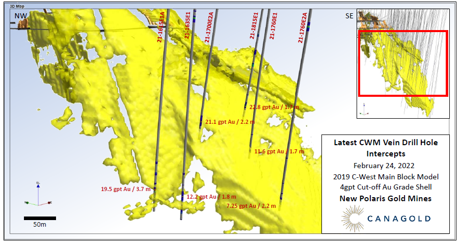
The assay results include samples from drill holes that have returned significant intercepts of gold mineralization in the C-West Main ("CWM").
Highlights:
- 19.5 grams per tonne ("gpt") gold ("Au") over 3.7 metres ("m") from 427.3 m down the hole, in Hole 21-1615E1A
- 12.2 gpt Au over 1.8 m from 440.6 m in Hole 21-1635E1
- 21.1 gpt Au over 2.2 m from 327.3 m in Hole 21-1700E2A
- Including 38.6 gpt Au over 0.7 m from 327.9m
- 22.8 gpt Au over 1.7 m from 392.8 m in Hole 21-1760E1
- Including 28.9 gpt Au over 1.3 m from 393.2m
- 11.6 gpt Au over 1.7 m from 474.6 m in Hole 21-1760E2A
- 7.25 gpt Au over 2.2 m from 316.1 m in Hole 21-1815E1
Scott Eldridge, Canagold CEO, said, "These drill holes were designed to reduce the drill hole spacing within portions of the inferred resources so they can potentially be upgraded to indicated resources. These positive results further strengthen our confidence in the continuity and uniformity of grades and widths within the CWM vein system."
To view the full sized image, Click Here
To view the full sized image, Click Here
Detailed information for the six drill holes and the sample assay results and mineralized intercepts are provided in Table 1 and Table 2 below.
All of the planned 47-holes of the originally proposed 24,000 m infill drill program were completed by the end of 2021 and assay results have now been received for 28 holes. The samples collected from the mineralized zone in all of those holes have been submitted to the ALS Geochemistry lab in Whitehorse, YT for gold analysis. The drilling program is continuing through the winter. Results from the remaining holes of the original infill program and those to be drilled in the extended program will be released every few weeks as they become available throughout the winter and spring.
Infill Holes to Upgrade Inferred Resources to Indicated Resources
The current drill program is designed primarily to in-fill drill the Inferred Resources of the CWM vein system within the currently defined resources in the PEA*. The infill drill holes range in depth from 300 to 650 m and are designed to provide greater density of drill intercepts (20 - 25 m spacing) in areas of Inferred Resources between 150 and 600 m below surface. The improved drill density will be used to upgrade parts of the Inferred Resources to Indicated Resources for inclusion in a future feasibility study.
*The New Polaris resource is contained within a preliminary economic assessment ("PEA") report which was prepared by Moose Mountain Technical Services in the format prescribed by NI43-101 Stand