Johnson's 2015 PEA stated... 329,569,000
M + I tonnes 846,389,000 Inferred tonnes
2015 PEA Mineral Resource Estimate by Category – At a 0.57 g/t Pt Eq. or 0.15% Ni Eq. cut-off (Base Case)
| | | | | | | | | | | |
| Measured | 92,293 | 0.550 | 0.252 | 0.246 | 0.052 | 0.260 | 0.155 | 0.015 | 1.713 | 0.449 |
| Indicated | 237,276 | 0.511 | 0.231 | 0.238 | 0.042 | 0.261 | 0.135 | 0.015 | 1.656 | 0.434 |
| Total M&I | 329,569 | 0.522 | 0.237 | 0.240 | 0.045 | 0.261 | 0.141 | 0.015 | 1.672 | 0.438 |
| Inferred | 846,389 | 0.507 | 0.234 | 0.226 | 0.047 | 0.237 | 0.139 | 0.015 | 1.571 | 0.412 |
What measurement creates the M + I ?
900mL x 400mD x 300mW x 2.8 ore density
302,400,000 tonnes ( pretty darn close )
Image ( only factor circled zone ) 100m blocking
https://image.slidesharecdn.com/prophecyplatinumpresentation-120206130514-phpapp02/75/prophecy-platinum-presentation-19-2048.jpg?cb=1671716840
So far so good...
But how did they arrive at 846,389,000 million tonnes inferred ?
This is where Johnson, Juhnson factored = 2.5 km footprint and deeper depths.
Look at the image again.
----------------------------------------------------------------------------------
So what happen when you move westerly going beyond the
900m initial M + I constraint ???
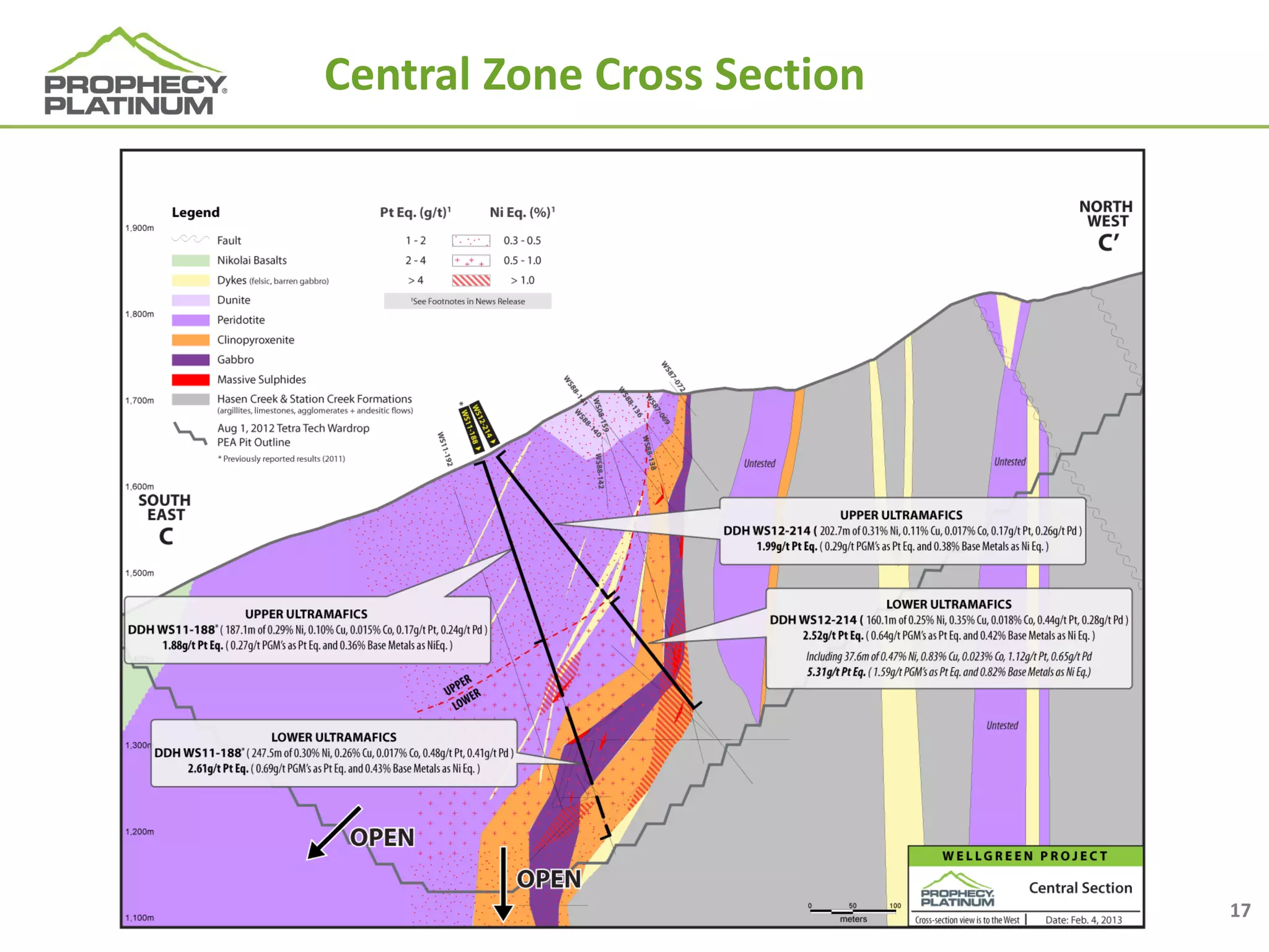
You arrive at the central Zone.
What's at the Central zone ?
If you look at older charts it shows a break, shearzone with shallow intercepts.
BUT....if you refer to other images something better reveals itself.
WS 11 - 188 - 457.3m 2.11/g Pt Eq
WS 12 - 214 - 362.7m 2.22/g Pt Eq
And.... the revealing of.... Backside of wellgreen.
I'll talk about backside later in post.

Central Zone
Suddenly.... older drill images are replaced with, deep intercepts.
These are outside the boundary of, the circled Wellgreen zone.
Inferred = because they needed to perform infill drilling.
Infill was performed.
BUT....just like the west zone, central was never fully measured with - M + I.
Remember ?
900mL x 400mD x 300mW x 2.8 ore density
302,400,000 tonnes ( pretty darn close to Johnson's M + I )
See anything interesting in that image ?
Backside of wellgreen is just as large as fron side.
First upper image shows red zone extends to opposite side
which would place the surface N to S width to 800 - 100m wide.
I only used 300m width to arrive @ 302 million tonnes.
= 2015 PEA ( close to 329 million tonnes )
Which paints a new picture of,
Central's long intercepts are = inferred
Backside wellgreen = all new tonnage
Depending on which image you look at,
WS 11 - 188 - 457.3m 2.11/g Pt Eq
This hole was drilled near peak of Central zone.
Another image shows backside placement and.....open at depth.
LOOK...... lower image.
Notice backside of wellgreen how much larger the footprint
of red mineralization.
Image is in.... 200m blocking
= 1000m from south to north.
= no longer 300m footprint.
= backside looks larger than the front of, wellgreen. ( bottom image )
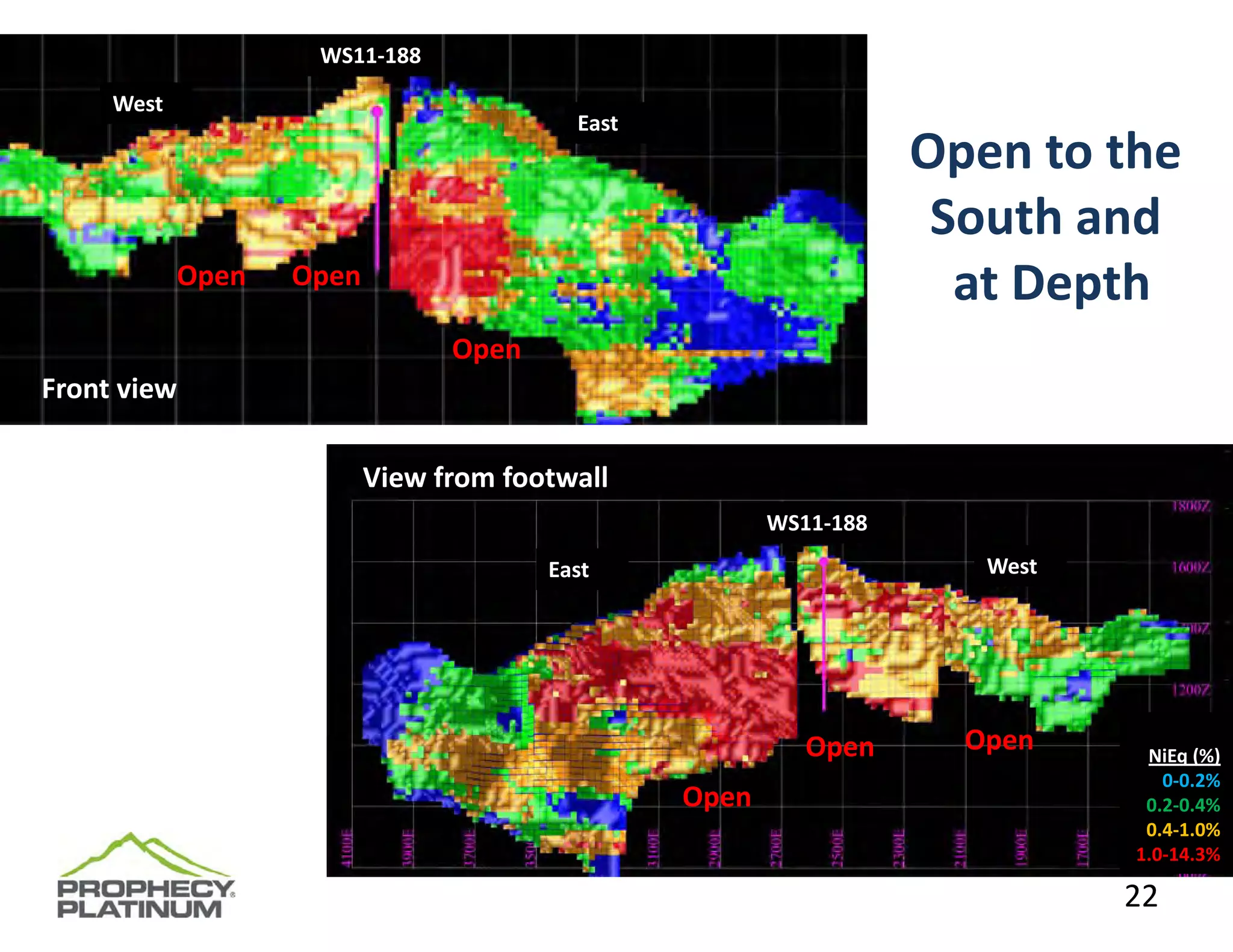
So why is Drill Hole 188 so important ?
This image shows 2 mineral zones ( upper and lower ultramafics )
Peridotite = Upper
What was sent to XPS ?
Peridotites. ( 1/2 legnth whole cores = points to upper ultramafics = peridotites )
Lower is different geology but still 1/2 mineralized.
This link image shows the 13 holes ( 7 outside the wellgreen.
https://mma.prnewswire.com/media/553093/Wellgreen_Platinum_Ltd__Wellgreen_Platinum_Provides_2017_Drill_P.jpg
= Many from Central.
XPS can't handle Peridotites, at least not Yukon's - lol.
But Timmin's area is perfectly fine....
What did the Practical Entitlement do to.... inferred 846 mil tonnes ?
86% reduction.
June 2017 press release.
SOLUTION ?
1- could've sent lower hole ultramafics.
2- use anothers diff extraction suited to peridotites
3- apply phase 1 recoveries ( bulk ) no problem with peridotites
= activates 846 million tonnes ( which has seen infill drilling )
SUM ?
Hole 188 is an important hole.
If drilled atop or top backside - it reveals a much deeper depth of mineralization.
Which brings into question, 1000m N to S width of, Wellgreen.
And.... 846 million tonne inferred.
Diff extraction - or phase 1 = would reactivate = 846 million tonnes
They did perform infilling.
What else is interesting ?
Miller (1991) found that the disseminated mineralization is preferentially enriched in copper, platinum, palladium and gold compared to the massive sulphides. Sulphur isotope data suggest that most of the sulphur was assimilated from deep crustal sources and was not derived from footwall rocks.
https://data.geology.gov.yk.ca/Occurrence/14129#InfoTab
Peridotite = has the disseminated mineralization.
Same minerals - all one source = no division accept some have more silicate.
= somewhat destroys the concept of....using only half whole cores.
= especially when phase 1 had no issue with silicates. ( peridotite )
I'd like to chat with Johnson...
Ask him where he drilled the - 750+m hole.
Wellgreen is also considered the East zone.
Go back far enough in the historicals... there was only - east and west.
What if far east was the backside of, wellgreen ?
Northern side.
Something to ponder.
Seems several juniors shifted the boundaries and names over the years.
Even burwash which was northerly, now overlays east and, far east going away
from main wellgreen.
If 3 deep bore holes drilled Burwash, and if Burwash now overlays east, far east,
and press didn't reveal assays only states silicate/ then....where were these holes ?
North side of wellgreen - or east, far east or, original burwash ?
I've even seen an image showing west zone having it's own, east and west.
I like seeing goal post boundaries remain same from start to finish.
Any wonder why this project is a bugger to, understand.
lol
Cheers....