PLACER MOUNTAIN MAPCARTA https://mapcarta.com/24557492 A good portion of Placer Mountains perimeter is seen with ( grey rocks ) and what appears as a carbonate influence. That's the geology i like to see when comparing with, Copper Mountain.
In the Copper Mountain report - it's said that exploration measures to identify a potential resource of copper was in the form of a submarine. Bague yes, as most ranges in this area are submarine in shape, lol.
But... Placer Mountian does have that disposition of a submarine striking north easterly.
There's another smaller submarine north west ( immediate ) that strikes directly north with the same grey carbonic rock with white carbonic nature.
Referencing Copper Mountain ( scan several km ) north of Placer Mountain, one will see sugar coated red terrain geology with major grey rocks and masisve carbonate influences with in the pits. Evident, that the grey rocks are the target species, for copper.
On the south western side of Placer Mountain,
there is seen a weaving seam of what appears as float rocks inbedded in the mountain or, could be an elevated sedimentry band meandering and coursing the side. Regardless, i'm rather excited to see what Darmara finds on PLacer Mountain - and am hoping they place just as much focus on the GREY rocks with carbonates as they do with hunting the quartz veins or, float boulders.
That's my take on the copper - grey carbonic ( sodic ) geology.
Hoping Darmara connectswith a copper find.
If they do... i would also hope they bumpup their ownership another 10 - 15% wink.
Giggles.
As for the veins down in the valley harboring gold ?
Can i question the directional path ?
Could i propse another view and say, what if this is a sedimentry overlap - Princeton ovderlapping the Nicola and what if this is a ( thin ) sedimentry band that is shaped like a pancake sheet - instead of a thin vein ?
What if, the numerous trenches that are apparently cut opposed to the vein are actually running same directional patrh as the - sheet ?
It would mean the veining is moreso a - pancale sedimentry thin sheet -
It wouldn't take much ot strip back the ground in oppsite direction of current trnches to see if this rings true. If it does... it would match the geological theory of Copper Mountain, in which propses that there are two geologies - whereas - one intrudes and overlaps.
Two geologies would definitely create a thin overlap - and run at depth from whence the overlap originates -meaning - the potential sedimentry sheet would run all the deeper.
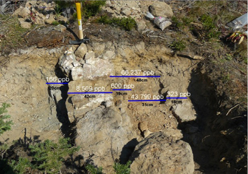
In the Darmara trench photo i can clearly see a potential sediment sheet with what appears as a blow out section of a carbonic intrusion in center - which could also relate as a carbonic intrusion - pipe like - where carbonates and quartz may have interupted the sediment sheet.
- jacket on ground = angle and pitch is seen in vein, or, sediment sheet.
- jacket on ground quartz - carbonc = intrusion ?
https://www.damaragoldcorp.com/uploads/1/0/4/8/104823939/background-images/643472043.jpg Again, are they dealing with a - thin sediment overlap sheet ?
Two geologies interfacing with acarbonci intrusion from depth that interupts the sheet ?
Here is another photo from another junior ( formerly Canarc )
Again ,same theory of thin vein... but, could it be a pancake sediment sheet ?
I'm clearly seeing the vein, but it appears as a sediment sheet, i can clearly see the directional pitch - a directional path that runs deeper as a sediment sheet would do if raised ( thruisted up ) on pitch / angle.
Canarc - even mentions the vein running deeper at depth beyon 6 meters whereas the backhoe could not reach. This also suggests a thin sheet that has pitch running deeper.
Lastly, this vein is tracked by Canarc, Universal, and now Darmarsa is taking a poke at it
I would simply say.... begin a new trench grid in opposite direction to eliminate or prove the potenitality of a sheet like sedimentry body that may run broad and wide, overlapping the
other geoplogy and tracks deeper at depth.
Just look at the pitch this exposed vein has, clearly runs deeper.
A simple exposing of the ground in other direction could easily prove if it's a sedimentry sheet.