Join today and have your say! It’s FREE!

Become a member today, It's free!

We will not release or resell your information to third parties without your permission.
Please Try Again
{{ error }}
By providing my email, I consent to receiving investment related electronic messages from Stockhouse.

or

Sign In

Please Try Again
{{ error }}
Password Hint : {{passwordHint}}
Forgot Password?

or

Please Try Again {{ error }}

Send my password

SUCCESS
An email was sent with password retrieval instructions. Please go to the link in the email message to retrieve your password.

Become a member today, It's free!

We will not release or resell your information to third parties without your permission.
Quote  |  Bullboard  |  News  |  Opinion  |  Profile  |  Peers  |  Filings  |  Financials  |  Options  |  Price History  |  Ratios  |  Ownership  |  Insiders  |  Valuation

Ivanhoe Mines Ltd T.IVN

Alternate Symbol(s):  IVPAF

Ivanhoe Mines Ltd. is a Canada-based mining, development, and exploration company. The Company is focused on the mining, development and exploration of minerals and precious metals from its property interests located primarily in Africa. Its projects include The Kamoa-Kakula Copper Complex, The Kipushi Project, The Platreef Project., and The Western Foreland Exploration Project. The Kamoa-Kakula Copper Complex project stratiform copper deposit with adjacent prospective exploration areas within the Central African Copperbelt, approximately 25 kilometers (km) west of the town of Kolwezi and about 270 km west of the provincial capital of Lubumbashi. The Kipushi mine is adjacent to the town of Kipushi in the Democratic Republic of the Congo (DRC) approximately 30 km southwest of the provincial capital of Lubumbashi. The 21 licenses in the Western Foreland cover a combined area of 1,808 square kilometers to the north, south and west of the Kamoa-Kakula Copper Complex.


TSX:IVN - Post by User

Bullboard Posts
Comment by gruntov1on Oct 09, 2018 3:21pm
115 Views
Post# 28768305

RE:Angry Geo does IVN

RE:Angry Geo does IVNI tried to make a copy of the article.


Sunday, October 7, 2018

Ivanoe - Makoko-loco

 
Ivanhoe have been finding massive amounts of copper in the DRC at Kamoa-Kakula, but they've just announced a new discovery (link) Makoko.

It was great that they included most of the drilling data in the press release, and from that I have been able to model the mineralization (Leapfrog Model here):

 
I've also used the data to come up with a resource guesstimate.


Not in the same scale as Kamoa, but a start.

Assumptions: These are based on the data used in the Kamoa PEA


Cut-off: 1% Cu

Specific Gravity: 2.8 to 2.9 depending on the Cu grades (the more Cu, the higher the SG)

 
Search Ranges: 

  • 800m (Kamoa PEA) but 
  • I've also included a 1600m range to match the 'limits' used in the various maps that are found on the Ivanhoe website.
You can clearly see that there is a core >4% Cu Zone that appears to be truncated by the Mafic intrusive, but, several wide-spaced holes (>500m apart) appear to show the >2.5% Cu mineralization extending to the SE.


Unfortunately, there appear to be some post-mineral mafic intrusions that appear to truncate the down-dip extension of the >3% Cu mineralization. The  good news is that the at the eastern and western limits of the drilling they are still intersection >2% Cu mineralization over moderate thicknesses (2-5m).
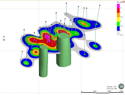
 
Mafic units in green - I'm assumed that they are approx. vertical cylinders, which is probably wrong 
It will be interesting to see if the Cu horizon continues beyond the intrusions, but if it does, it will be at ~700m depths. There have been a few holes drilled up-dip, but they have returned intervals grading <1% Cu.
 
Green Unit = Mafic intrusion; thin red unit = Cu bearing horizon.
 
However, I'm going to guess that my 'estimate' will be low. I've made a few annotations on the plan map above where there is a bit of "artistic license". You'll see how the influence of the low grade intercepts are being reduced to cause the smallest of ripples on the sea of high-grade mineralization that Ivanhoe want to show. It will be interesting if this 'interpretation' continues into the initial resource estimate or if the holes are treated a but more equally.
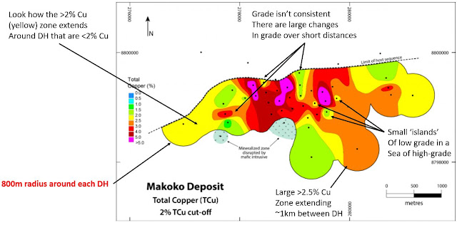
 
 
correction: it should read 800m DIAMETER around each DH


  1.  


Sunday, October 7, 2018

Ivanoe - Makoko-loco

 
Ivanhoe have been finding massive amounts of copper in the DRC at Kamoa-Kakula, but they've just announced a new discovery (link) Makoko.

It was great that they included most of the drilling data in the press release, and from that I have been able to model the mineralization (Leapfrog Model here):

 
I've also used the data to come up with a resource guesstimate.


Not in the same scale as Kamoa, but a start.

Assumptions: These are based on the data used in the Kamoa PEA


Cut-off: 1% Cu

Specific Gravity: 2.8 to 2.9 depending on the Cu grades (the more Cu, the higher the SG)

 
Search Ranges: 

  • 800m (Kamoa PEA) but 
  • I've also included a 1600m range to match the 'limits' used in the various maps that are found on the Ivanhoe website.
You can clearly see that there is a core >4% Cu Zone that appears to be truncated by the Mafic intrusive, but, several wide-spaced holes (>500m apart) appear to show the >2.5% Cu mineralization extending to the SE.


Unfortunately, there appear to be some post-mineral mafic intrusions that appear to truncate the down-dip extension of the >3% Cu mineralization. The  good news is that the at the eastern and western limits of the drilling they are still intersection >2% Cu mineralization over moderate thicknesses (2-5m).
 
Mafic units in green - I'm assumed that they are approx. vertical cylinders, which is probably wrong 
It will be interesting to see if the Cu horizon continues beyond the intrusions, but if it does, it will be at ~700m depths. There have been a few holes drilled up-dip, but they have returned intervals grading <1% Cu.
 
Green Unit = Mafic intrusion; thin red unit = Cu bearing horizon.
 
However, I'm going to guess that my 'estimate' will be low. I've made a few annotations on the plan map above where there is a bit of "artistic license". You'll see how the influence of the low grade intercepts are being reduced to cause the smallest of ripples on the sea of high-grade mineralization that Ivanhoe want to show. It will be interesting if this 'interpretation' continues into the initial resource estimate or if the holes are treated a but more equally.
 
 
correction: it should read 800m DIAMETER around each DH


Bullboard Posts