Rockland identifies new target at Cole Gold Mines Property ROCKLAND RESOURCES’ GEOPHYSICAL STUDY IDENTIFIES PROSPECTIVE TARGET TREND AT COLE GOLD MINES PROPERTY, RED LAKE MINING DIVISION, ONTARIO
Vancouver, British Columbia, June 21, 2021: Rockland Resources Ltd. (the "Company" or "Rockland") (CSE: RKL) is pleased to announce that a recently completed analysis of aeromagnetic data for the Cole Gold Mines Property has identified an over one km long prospective linear magnetic low trend west of the historically defined Cole Gold Deposit. This target will be tested as part of Rockland’s 2,500 metre drill program that is planned to start at the end of this month.
Jeremy S. Brett, MSc, P.Geo completed an analysis of a high-resolution heli-magnetic survey flown at 50 metre line spacing over the Cole Gold Mines property. Mr. Brett’s study included an analysis of linear magnetic features evident on total field and tilt derivative magnetic maps and an analysis of the relationship of 3-dimensional (3D) magnetic inversions with major rock types and geological structures.
Mike England, Rockland’s CEO stated "We are very pleased to have results of this geophysical analysis that has identified a highly prospective trend that extends for over 1 km west of the Cole shaft. The Cole Property, located in the prolific Red Lake greenstone belt, has had no exploration for nearly 50 years. To our knowledge, our upcoming drill program will be the first time this trend has been drill tested west of the shaft.”
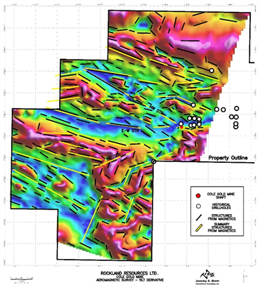
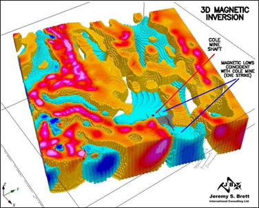
The geophysical analysis shows that the Cole Gold shaft is located on a prominent east-west striking feature characterized by a broad magnetic low on the total magnetic intensity map and a more discrete, narrow, magnetic low feature on the tilt derivative map (Figure 1). This trend is shown in 3D on the magnetic inversion (Figure 2). In addition, to the main east west trend, an additional magnetic low feature is present in the south west part of the Property that is associated with mineralized quartz veins identified in recent surface prospecting efforts. This trend could be a distinct lithology or a zone of alteration that acts as a control on gold mineralization.
Rockland will initiate a 2500 metre core drilling campaign that will initially test gold mineralization that was defined by the Cole Gold Mines Limited underground development work and historic Kerr Addison (1973) diamond drilling. In addition to the prospective geophysical trend identified in the current study, the Rockland drill program will also test surface showings that returned recent grab sample values up to 14.8 g/t Au. The property has an approved exploration permit PR-20-000368, that is valid until March 2024.
The Cole Gold Property historically indicated high-grade gold values are associated with sphalerite-chalcopyrite-scheelite-bearing quartz veins in shear and structural zones in porphyry and felsic rocks, striking approximately east-west and dipping steeply to the north. Mineralization is located in a regional structural corridor known as the Pipestone Deformation Zone. Underground development work by Cole Gold Mines in the 1930’s included a vertical shaft to a depth of 161.5 metres (530 feet), with four levels established, and over 2,133.6 metres (7,000 feet) of drifting and crosscutting (mostly on vein) and 1,219.2 metres (4,000 feet) of underground diamond drilling.
The magnetic data analysis was completed by Jeremy S. Brett, M.Sc, P.Geo, Senior Geophysical Consultant, Jeremy S. Brett International Consulting Ltd. Mr. Brett has over 25 years of international exploration experience, including gold exploration in various geological settings in North / Central / South America and Africa. Garry Clark, P.Geo, a qualified person under National Instrument 43-101, is the qualified person responsible for reviewing and approving the geological contents of this news release as they pertain to the Cole gold mines property.
Figure 1. Cole Gold Mines Property, Aeromagnetic Survey Tilt Derivative Map with Structural Trend Analysis. Prominent NE, E-W and NW structural trends are evident, which could act as controls on alteration and gold mineralization.

Figure 2. Cole Gold Mines Property, 3D Magnetic Inversion. A distinct E-W striking magnetic low is coincident with the Cole Mine Shaft, and could represent a sub-vertically dipping lithological unit or altered structural zone. This could be a main control on gold mineralization at the Cole Gold Mine and along strike.

About the Cole Gold Mines Property
Rockland Resources Ltd. is acquiring a 100-per-cent interest in the Cole Gold Mines Property, located in Ball township, Red Lake Mining Division, Ontario. The Property consists of 28 mining claims (568 ha) located 30 km west of the Cochenour, Campbell, Red Lake mine complex owned and operated by Evolution Mining. The Property represents a rare opportunity to explore a strategically located asset in one of the most active, prolific producing mining districts in Canada. The property hosts high-grade gold values in a classic Red Lake-type quartz vein and silica-sulphide replacement zones.
About Rockland Resources Ltd.
Rockland Resources is engaged in the business of mineral exploration and the acquisition of mineral property assets in Canada. Its objective is to locate and develop economic precious and base metal properties of merit and to conduct its exploration program on the properties. In addition to the Cole Gold Property, Rockland is exploring the Summit Old Timer Property that consists of three (3) mineral claims covering an area of 1,915 hectares located approximately 17 km southeast of the City of Nelson, within the Nelson Mining Division, British Columbia.
On Behalf of the Board of Directors
Richard Sutcliffe
President and Director
For further information, please contact:
Mike England
Email: mike@engcom.ca