RE:RE:Storm copper AWM view The Hidden value goes unrecognized, because of the Canadian Securities strict laws purtainting on what a junior exploration co, can say in their news releases.The Aussie"s can, dialouge forward conversation on how they are going to run Storm "s DSO operation as seen in their Presentaton.
The market knows the rules and have the tools keeping BAY"S share MDA for 3 years at Lows Mill-second the closing Bell with a Down -Tick. It would be interesting to see who sits with BAY shares
Hidden Value
The current presentation here by AWM,. in my opinion. are planning to trial run a DSO next spring.The current all in-clusive and still to come drilling surface drilling from all 4 zones will 43-101/ jorc a 550,000 to / upto 750,000 tn of chalcocite . x $ 9,000.00 per tn.
BAY'S, 20% of say 6 Billion over 10 year dso life would see BAY earn a few 100million.
BAY , has alot of options to play out,..Lets say what IF, what IF Thomas has this mineral zonation figured out and directs the drill into a chalcocite blob as seen on slides,..
The game now changes,.. Multi-Billion surface deposit already proven with a low 50m capital being a green dso operation assited by Nunavut Government.
The copper Blob,..could be multi-Billions,.and this copper bed sits below the DSO operation at the 4100 zone,. The surface DSO becomes a open-pit and still being green .
The Hidden Value
stay tunned,
LARGE SIGNIFICANT TARGETS MODELED BY 3D INVERSION
A 3D inversion was completed on the gravity data to produce a series of gravity contrast iso-shells, which are designed to highlight the areas with the greatest density contrasts in 3D (Figures 5 & 6). These could represent potential areas of stronger copper mineralization and are high priority drill targets.
The largest of the 3D gravity targets is located along the northern fault and directly underneath the 4100N Zone (Figures 5 & 6). The feature commences at approximately 200m depth and is approximately 2.3km long. The gravity feature is coincident with a strong historical IP anomaly on its upper contact. This is a highly significant association and indicates a both dense and electrically chargeable body. The only known dense and chargeable geological feature at depth in the Storm area are sulfides.
Several other gravity targets are also defined by the 3D inversion along the southern fault. The data indicate that a strong gravity anomaly is located near the surface to the west of the high-grade 2750N Copper Zone. This location also features strong EM and IP anomalies associated with known copper mineralization in sparse, shallow historic drilling (5m @ 2% Cu and 0.8m @ 20% Cu in drill hole ST00-66).
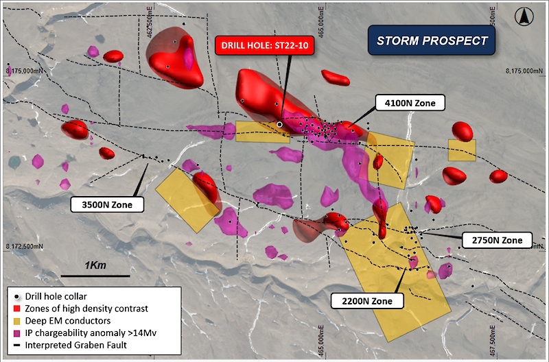
Figure 5: Geophysical summary map showing the new gravity density contrast anomalies,deep EM conductors
and strong IP (>14Mv) anomalies (overlaying drill collar locations, graben faults and topography).
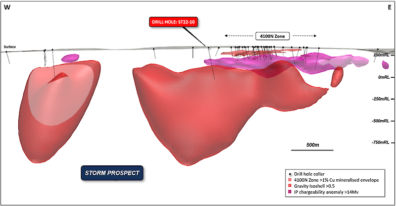
Figure 6: East-West long section showing the large density anomaly (red) underneath the 4100N Zone mineralization.
Note the strong IP anomaly (magenta) is spatially coincident with the top of the gravity anomaly.
DRILL HOLE ST22-10 –THE EDGE OF A MAJOR COPPER SYSTEM?
Exploration drill hole ST22-10 was completed in 2022 targeting a large EM anomaly to the west of, and at a deeper stratigraphic level than, the near-surface high-grade 4100N Zone. The EM anomaly is located on the southern edge of a strong airborne gravity anomaly associated with the northern graben fault.
The drill hole intersected a thick sequence of copper and zinc sulfide-bearing mineralization hosted within carbonate sediments before being abandoned due to technical drilling issues. Approximately 68.8m of chalcopyrite-bearing sulfide mineralization (Figure 7) was intersected from 277m downhole (approx. 230m vertical depth), remaining open at depth. The sulfide mineralization is interpreted to be stratabound and is hosted within a vuggy, bituminous and fossiliferous unit.
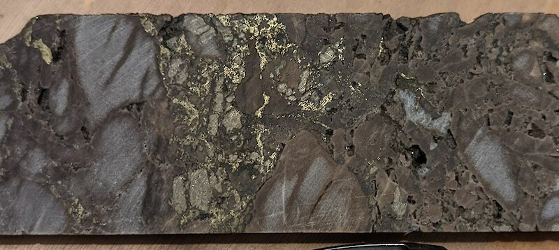
Figure 7: Chalcopyrite (copper sulfide), pyrite (iron sulfide), sphalerite (zinc sulfide) and galena (lead sulfide)
within vuggy bituminous dolostone in ST22-10 drill core from 313m downhole.
A distinct zonation of metal associations and mineralogy is noted at the 4100N, 2750N and 2200N Zones at Storm: a large copper-rich core (chalcocite, bornite and covellite) gives way laterally and vertically to thinner peripheral zones of copper-iron (chalcopyrite), iron (pyrite), zinc (sphalerite) and minor lead (galena). ST22-10 intersected the peripheral mineralogical assemblage (chalcopyrite, pyrite, sphalerite and galena) suggesting the potential for a nearby larger, more copper-rich core.
The metal associations and zonation of the mineralization suggest that drill hole ST22-10 potentially intersected the edge of a larger copper system.
Additionally, the geology displays all the elements required in the sediment-hosted mineralization forming process: permeable carbonate rocks to act as a fluid conduit and host mineralization, hydrocarbons to reduce metal-bearing fluids and force metal precipitation, sulfur source from bitumen and sour gas, proximity to faults known to be an effective source for plumbing, all within a favourable structural setting.
These key features are similar to many of the world’s major sediment-hosted copper systems, including the deposits of the Kalahari Copper Belt (Botswana) and Central African Copper Belt (DRC, Zambia).
The three-dimensional interpretation of the 2023 gravity data suggests that drill hole ST22-10 was drilled just to the south of, and likely intercepted the margin of, the large anomaly below and to the west of the 4100N Zone (Figures 5 & 6).
Both the metal zonation and geophysical modeling suggest the intersection of the periphery of a potentially larger mineralized zone. As such, the large gravity anomaly below the 4100N Zone and to the northwest of ST22-10 is a key target for the discovery of additional copper sulfides.
Diamond drilling will test this and other highly prospective exploration targets that sit at 200m to 500m below the surface.
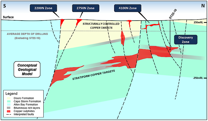
Figure 8: Conceptual geological and exploration targeting model for the Storm Project,
showing depth of current drilling and conceptual location of discovery drill hole ST22-10.
GAME-CHANGING TARGETING TOOL
The 2023 high-resolution ground gravity survey was designed to follow up historical airborne and limited ground gravity surveys. The prior surveys had identified a series of broad density anomalies that lay adjacent to the large graben faults – interpreted to be conduits for copper-forming fluids - and below known near-surface copper sulfide mineralization.
Given the high contrast in density between copper sulfide mineralization and the mostly homogenous dolomite sedimentary host rocks at Storm, this geophysical technique was expected to be an effective targeting tool.
The new survey has provided high-quality data and a significant increase in the understanding of the Storm graben area. The survey included a total of 2,657 gravity stations (Figure 9), with an approximate station spacing of 150m x 50m (E-W and N-S respectively). Topographic surveying was performed simultaneously with gravity data acquisition, and terrain corrections were applied to the data.
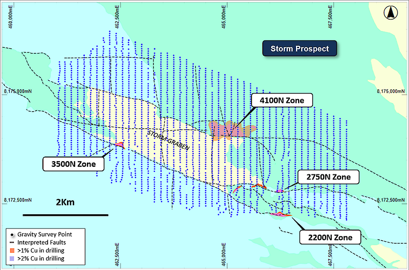
Figure 9: Ground gravity station locations overlaying geology.
PLANNED PROGRAM
- Drilling at the 4100N Zone will continue in the summer field program, with a focus on th expansion of the mineralized footprint. This program will be followed by resource definition drilling at the 2200N and 2750N Zones – drilling here intersected high-grade copper sulfides close to surface including 41m* @ 4.18% Cu from 38m (ST22-05), 110m* @ 2.45% Cu from surface (ST97-08) and 56.3m* @ 3.07% Cu from 12.2m (ST99-19).
- Processing and interpretation of the Moving Loop EM (MLEM) data collected during the spring program are almost complete.
- Diamond drilling will be scheduled to test new high-priority exploration targets identified from the gravity survey.
- Sorting and beneficiation test work for a potential direct shipping product operation is continuing with results to follow shortly.
- An environmental baseline survey is scheduled to begin this summer at Storm.
About the Storm Copper and Seal Zinc-Silver Projects, Nunavut
The Nunavut property consists of 173 contiguous mining claims covering an area of approximately 219,257 hectares on Somerset Island, Nunavut, Canada. The Storm Project comprises both the Storm Copper Project, a high-grade sediment-hosted copper discovery (intersections including 110m* @ 2.45% Cu from surface and 56.3m* @ 3.07% Cu from 12.2m) as well as the Seal Zinc Deposit (intersections including 14.4m* @ 10.58% Zn, 28.7g/t Ag from 51.8m and 22.3m* @ 23% Zn, 5.1g/t Ag from 101.5m). Additionally, there are numerous underexplored and undrilled targets within the 120-kilometre strike length of the mineralized trend, including the Tornado copper prospect where 10 grab samples yielded >1% Cu up to 32% Cu in gossans.
Storm Discovery and Historic Work
High-grade copper mineralization was discovered at Storm in the mid-1990s by Cominco geologists conducting regional zinc exploration around their then-producing Polaris lead-zinc mine. A massive chalcocite boulder found in a tributary of the Aston River in 1996 was traced to impressive surface exposures of broken chalcocite mineralization at the surface for hundreds of metres strike length at what became named the 2750N, 2200N, and 3500N Zones. Subsequent seasons of prospecting, geophysics, and over 9,000 m of drilling into the early 2000s confirmed a significant amount of copper mineralization below the surface exposures as well as making the blind discovery of the 4100N Zone, a large area of copper mineralization with no surface exposure.
Following the merger of Cominco with Teck in 2001 and the closure of the Polaris Mine, the Storm claims were allowed to lapse in 2007. Commander Resources re-staked the property in 2008 and flew a helicopter-borne VTEM survey in 2011 but conducted no additional drilling. Aston Bay subsequently entered into an earn-in agreement with Commander and consolidated 100% ownership in 2015. Commander retains a 0.875% Gross Overriding Royalty in the area of the original Storm claims.
In 2016 Aston Bay entered into an earn-in agreement with BHP, who conducted a 2,000-station soil sampling program and drilled 1,951m of core in 12 diamond drill holes, yielding up to 16m* @ 3.1% Cu. BHP exited the agreement in 2017. Aston Bay conducted a property-wide airborne gravity gradiometry survey in 2017 and drilled 2,913m in nine core holes in the Storm area in 2018 yielding a best intercept of 1.5m* @ 4.39% Cu and 20.5m* @ 0.56% Cu.
Agreement with American West Metals
An earn-in agreement for the Storm and Seal properties was signed with American West Metals in March 2021. Under the terms of the agreement, an expenditure of C$10m will earn 80% ownership of the property for American West. Aston Bay is carried for all expenditures to the completion of a feasibility study and production decision. If Aston Bay chooses not to participate and is diluted below 10% ownership, the ownership converts to a 2% Net Smelter Royalty, half of which is purchasable by American West for C$5m at first production. Aston Bay received a cash payment of C$500,000 on signing.
Recent Work
American West completed a fixed loop electromagnetic (FLEM) ground geophysical survey in 2021 that yielded several new subsurface conductive anomalies. A total of 1,534m were drilled in 10 diamond drill holes in the 2022 season, yielding several impressive near-surface intercepts including 41m* @ 4.1% Cu as well as 68m of sulfide mineralization associated with a deeper conductive anomaly.
In April 2022 results of beneficiation studies demonstrated that a mineralized intercept grading 4% Cu from the 4100N area could be upgraded to a 54% Cu direct ship product using standard sorting technology. Further beneficiation studies are ongoing.
In April 2023 American West embarked on a spring delineation drilling program using a helicopter-portable reverse circulation (RC) drill rig as well as gravity and moving loop electromagnetic (MLEM) ground geophysical programs. Results from the programs are in process and are released as they come available.
A summer 2023 program plans further delineation drilling of the near-surface high-grade copper zones to advance them toward maiden resource reports by late 2023. Diamond drilling is planned to test new high-priority gravity targets and environmental baseline studies will be initiated.
*Stated drill hole intersections are all core length, and true width is expected to be 60% to 95% of core length.
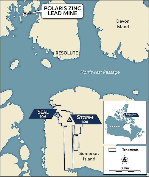
Figure 10: Storm Copper Project, Location Map.
Qualified Person
Michael Dufresne, M.Sc., P.Geol., P.Geo., is a qualified person as defined by National Instrument 43-101 and has reviewed and approved the scientific and technical information in this press release.