BRUNSWICK METASEDIMENT DEPOSITS BC is well known for it's metasediment deposits.
Deposits located between cordillera mountain ranges / corridors that fill with a variety of
ore, sands, tills carried in by errosion, weathering and torrid rushing waters.
Laying down layer after layer of, breccia, gabbros, silicates and larger float rock.
Leached calcium limes.... assist with cementing and reconsolodating.
Does New Brunswick host metasediment deposits ?
After all... there are several large runways which formed from faults and...lots of
signs waters once coursed through these laneways.
McBean Brook located in mid/south region of New Brunswick
large corridor fault
metasediment deposit MAP
https://www.google.com/maps/place/McBean+Brook/@46.1732468,-66.635267,13z/data=!4m6!3m5!1s0x4ca40f1a28f90cb9:0xd18b7e6e385bd7d4!8m2!3d46.1662334!4d-66.6091745!16s%2Fg%2F11cjk35k0d!5m1!1e4?entry=ttu&g_ep=EgoyMDI0MDgyOC4wIKXMDSoASAFQAw%3D%3D Abstract Mineralization at the McBean Brook Zn-Pb-Ag prospect (central New Brunswick) occurs in fault-brecciated Ordovician metasedimentary rocks and Mesozoic diabase dyke rocks. The dyke is interpreted to form part of the early Jurassic Caraquet dyke because it is on strike with the Caraquet dyke, has the same NE-SW orientation, and is similar in mineralogy (containing large plagioclase phenocrysts and olivine) and chemistry (e.g., Ti02 and Ga concentrations and Zr/Y ratios). Thus the mineralization at McBean Brook, consisting of carbonate, quartz, pyrite, pyrrhotite, sphalerite, galena, and chalcopyrite, is probably early Jurassic or younger. https://www.erudit.org/en/journals/ageo/1990-v26-n1-ageo_26_1/ageo26_1art01/
There we have it.
Metasedimentry deposits do exist in, New Brunswick.
GOODWIN historical drilling at granges drilled aside the metasediments
historical drills ( few ) pointed towards metasediments
Slam ( based on drill plot locations on surevey maps )
began drills at goodwin and aimed towards interior corridoes.
Interrior corridors are the fault watershed fairways.
Fairways that come from
Dome, Half Mile, Logan, Venning. Several ranges contributing to sediment build up.
And especially from the main Dome fairway carrying in, all sorts of geologies..
one can see the sediment basin
from upper granges right through to, goodwin lake.
Logan, Dome and mtn west of Logan would contribute to Granges sediments.
Venning mtn, Half Mile corridor would contribute sediments to, Farq.

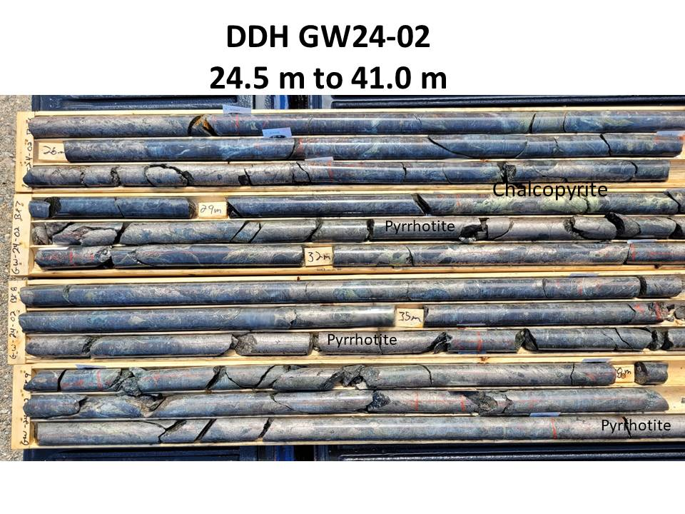
drill cores
would provide clues to know if drills are in host rock or, metasediments.
Slam offered photos of cores from
GW24-02 23.6m to 88.5m - 64.9m intercept -
2.19 % Cu Eq what do i see ?
no indigenous veining moreso post pockets of crystalizations
course silicate grains ( some unconsolodated = sand sediments
sulphides but no form that suggests - local formation - recons
loose silicates
3rd core from botton - left side first break, - sharp edge chard
same core middle break - cunky quartz
= sum could point to... reconsolodated geology from fairways settling in basin
= basin (
near fairways )
could offer up sediment style deposits.

Sent this to Slam
we've all heard of nine mile... this location i've coined five mile ( tease )
just one photo... but, area has the blond pyrite iron sulphides, calcs, blushing reds and this,
what appear as ----> blue sulphides at surface seen in contrast to flowing pink rhyolies aside.

Correction
GW24 01 22.5m to 57.5m 35m intercept ( former post said begsn at 2m )
Cheers...