Final 2018 Drill Results Continue to Confirm Expansion Potential for Salave Gold Resource
- High-grade gold intersections confirm and extend the current resource model, including best
results of:
BD18-07
-
23.3m @ 29.1 g/t Au from 164.8m including,
- 9.1m @ 65.1 g/t Au from 171.8m and,
- 3.4m @ 148.0 g/t Au from 176.0m
BD18-06
- 4.8m @ 16.3 g/t Au from 230.7m
-
14.0m @ 10.0 g/t Au from 209.9m, including
- 4.1 @ 24.5 g/t Au from 219.8m
- Select mineralised intersections in holes BD18-06 and BD-18-07 are outside of the limits of the
current mineral resource model.
Black Dragon Gold Corp. (ASX: BDG, TSX-V: BDG) ("Black Dragon" or the "Company") is pleased to announce the assay
results from the final two drill holes of the Company’s 2018 infill and definition drilling campaign at its wholly owned Salave
Gold Project in the Asturias region in northern Spain ("Salave" or the "Project").
This press release features multimedia. View the full release here: https://www.businesswire.com/news/home/20180924006062/en/
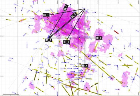
Figure 1: Plan Map showing 10 g/t Au blocks from MDA Mineral Resource Estimate (Photo: Business Wire)
The results from drill holes BD18-06 and 07 are significant because they have intersected high-grade mineralisation within and
beyond the constraints of the current Mineral Resource model. This continues to confirm the potential for significant exploration
upside to Salave’s existing measured and indicated resource of 6.52 million tonnes at 4.51 g/t Au, for 944,000 ounces of gold (see
February 2, 2017 news release).
The 2018 drill campaign has not only been successful in achieving the Company’s main objective of confirming the extent and
continuity of high-grade gold mineralisation at Salave, the 2018 drill programme has also extended the limits of mineralization
defined by the current Mineral Resource model.
The Company anticipates that the results from the 2018 drill programme will have a positive impact on the next Mineral Resource
estimate update, which is due for completion in early Q4 2018. The updated Mineral Resource update will be the basis for a
Preliminary Economic Assessment ("PEA") focusing on a new underground mine plan and also planned for completion by the end of
2018.
CEO and Managing Director of Black Dragon, Paul Cronin, commented:"I am very pleased with the outcome of the 2018 drill
programme at Salave. The drill hole results announced today and previously support our belief that not only the Salave
deposit is open to expansion, but there are also opportunities to discover new and expand existing zones of very high grade gold
mineralization within and outside of the existing resource model that will become the focus of our PEA and defining an underground
mine target."
"We will immediately proceed to compile the results of the 2018 drilling and generate a revised interpretation based on these
new results. The new interpretation will be the foundation of an updated Mineral Resource estimate, expected in early
Q4."
Select results from diamond drill holes BD18-06 and BD18-07 include:
| Hole |
|
From (m) |
|
To (m) |
|
Interval (m) |
|
Au(ppm) |
|
| BD18-06 |
|
96.75 |
|
107.50 |
|
10.75 |
|
3.28 |
|
| |
|
116.85 |
|
122.60 |
|
5.75 |
|
6.21 |
|
| Including |
|
116.85 |
|
117.90 |
|
1.05 |
|
15.80 |
|
| |
|
139.50 |
|
141.20 |
|
1.70 |
|
21.30 |
|
| |
|
151.00 |
|
157.00 |
|
6.00 |
|
4.63 |
|
| |
|
163.00 |
|
177.20 |
|
14.20 |
|
5.43 |
|
| Including |
|
170.75 |
|
172.50 |
|
1.75 |
|
14.30 |
|
| |
|
209.90 |
|
223.90 |
|
14.00 |
|
10.00 |
|
| Including |
|
209.90 |
|
212.55 |
|
2.65 |
|
10.78 |
|
| Including |
|
219.80 |
|
223.90 |
|
4.10 |
|
24.50 |
|
| |
|
230.70 |
|
235.50 |
|
4.80 |
|
16.33 |
|
| Including |
|
232.50 |
|
235.50 |
|
3.00 |
|
24.15 |
|
| |
|
|
|
|
|
|
|
|
|
| BD18-07 |
|
124.00 |
|
125.50 |
|
1.50 |
|
6.15 |
|
| |
|
144.50 |
|
149.00 |
|
4.50 |
|
12.70 |
|
| |
|
159.50 |
|
161.00 |
|
1.50 |
|
4.64 |
|
| |
|
164.75 |
|
188.00 |
|
23.25 |
|
29.09 |
|
| Including |
|
171.75 |
|
180.85 |
|
9.10 |
|
65.14 |
|
| Including |
|
176.00 |
|
179.35 |
|
3.35 |
|
148.03 |
|
| |
|
201.90 |
|
215.30 |
|
13.40 |
|
8.99 |
|
| |
|
228.70 |
|
231.50 |
|
2.80 |
|
13.98 |
|
| |
|
239.90 |
|
245.15 |
|
5.25 |
|
11.59 |
|
Mineralised intervals were selected to achieve a minimum grade consistent with the Mineral Resource grades deemed amenable to
underground mining methods in the 2017 MDA Mineral Resource estimate. The selected intervals included above were based on 2.5 g/t
Au cut-off grade, 2 metres minimum interval length and maximum continuous internal waste interval of 2 metres. Reported mineralised
intervals may not represent true widths. Collar locations were surveyed in UTM coordinates based on ERTS89 datum, Zone 29N – Please
see Appendix 1.
The 2018 drill campaign consisted of seven diamond holes (BD18-01 to 07) totalling 2,117 metres, targeting the north-west
quadrant of the current resource model and was designed to confirm the presence of steep structures associated with high-grade gold
mineralisation and to test for possible lateral extensions of flat to shallow west-dipping stacked lenses of mineralisation defined
in the Company’s current Mineral Resource model. The Company will be utilising the new information from the 2018 drill holes to
update the current Salave Mineral Resource estimate, which will be used as the basis for a PEA and ongoing feasibility study of an
underground mine at Salave. Previously released drill results from holes BD18-01 to BD18-05 (see April 14, 2018, and September 11
2018 news releases for full details):
| Hole |
|
From (m) |
|
To (m) |
|
Interval (m) |
|
Au(ppm) |
|
| BD18-01 |
|
125.00 |
|
129.35 |
|
4.35 |
|
41.90 |
|
| |
|
146.60 |
|
167.25 |
|
20.65 |
|
5.10 |
|
| Including |
|
146.60 |
|
157.90 |
|
11.30 |
|
7.42 |
|
| Including |
|
164.10 |
|
167.25 |
|
3.15 |
|
3.64 |
|
| |
|
199.60 |
|
206.40 |
|
6.80 |
|
8.25 |
|
| |
|
217.10 |
|
226.30 |
|
9.20 |
|
4.05 |
|
| Including |
|
217.10 |
|
220.20 |
|
3.10 |
|
7.13 |
|
| |
|
305.30 |
|
317.70 |
|
12.40 |
|
25.83 |
|
| Including |
|
312.55 |
|
317.70 |
|
5.15 |
|
52.99 |
|
| |
|
|
|
|
|
|
|
|
|
| BD18-02 |
|
121.70 |
|
129.00 |
|
7.30 |
|
4.69 |
|
| |
|
145.40 |
|
154.30 |
|
8.90 |
|
4.10 |
|
| |
|
177.25 |
|
184.25 |
|
7.00 |
|
4.12 |
|
| |
|
218.40 |
|
249.20 |
|
30.80 |
|
7.07 |
|
| Including |
|
218.40 |
|
232.50 |
|
14.10 |
|
9.89 |
|
| |
|
272.00 |
|
275.50 |
|
3.50 |
|
5.20 |
|
| |
|
294.00 |
|
297.95 |
|
3.95 |
|
8.30 |
|
| |
|
308.50 |
|
311.50 |
|
3.00 |
|
4.77 |
|
| Including |
|
310.00 |
|
311.50 |
|
1.50 |
|
8.88 |
|
| |
|
|
|
|
|
|
|
|
|
| BD18-03 |
|
159.75 |
|
165.90 |
|
6.15 |
|
8.18 |
|
| |
|
195.10 |
|
199.50 |
|
4.40 |
|
3.12 |
|
| Including |
|
195.10 |
|
196.50 |
|
1.40 |
|
5.91 |
|
| |
|
208.50 |
|
220.50 |
|
12.00 |
|
2.75 |
|
| |
|
257.55 |
|
261.40 |
|
3.85 |
|
4.52 |
|
| |
|
283.65 |
|
296.25 |
|
12.60 |
|
18.09 |
|
| |
|
313.55 |
|
318.00 |
|
4.45 |
|
10.58 |
|
| |
|
339.00 |
|
343.20 |
|
4.20 |
|
52.03 |
|
| |
|
|
|
|
|
|
|
|
|
| BD18-04 |
|
103.50
|
|
109.50 |
|
6.00 |
|
5.91 |
|
| |
|
167.00
|
|
171.50 |
|
4.50 |
|
6.05 |
|
| |
|
183.05
|
|
220.50 |
|
37.45 |
|
6.60 |
|
| Including |
|
209.00
|
|
219.00 |
|
10.00 |
|
13.43 |
|
| |
|
243.00
|
|
255.00 |
|
12.00 |
|
6.83 |
|
| |
|
266.00
|
|
269.00 |
|
3.00 |
|
3.87 |
|
| |
|
|
|
|
|
|
|
|
|
| BD18-05 |
|
147.00
|
|
152.60 |
|
5.60 |
|
6.00 |
|
| |
|
174.60
|
|
191.00 |
|
16.40 |
|
5.86 |
|
| Including |
|
174.60
|
|
179.85 |
|
5.25 |
|
8.66 |
|
| Including |
|
187.10
|
|
191.00 |
|
3.90 |
|
8.35 |
|
| |
|
199.90
|
|
212.00 |
|
12.10 |
|
8.02 |
|
| |
|
220.00
|
|
222.60 |
|
2.60 |
|
9.08 |
|
| |
|
234.10
|
|
250.80 |
|
16.70 |
|
17.60 |
|
| Including |
|
234.10
|
|
240.80 |
|
6.70 |
|
30.27 |
|
Mineralised intervals were selected to achieve a minimum grade consistent with the Mineral Resource grades deemed amenable to
underground mining methods in the 2017 MDA Mineral Resource estimate. The selected intervals included above were based on 2.5 g/t
Au cut-off grade, 2 metres minimum interval length and maximum internal waste interval of 2 metres. Reported mineralised intervals
may not represent true widths. Collar locations are UTM coordinate based on ERTS89 datum, Zone 29N – Please see Appendix 1.
The Salave Deposit consists of a series of stacked horizontal to shallow west-dipping lenses of mineralisation associated with
altered (advanced sercitisation and albitisation) fracture zones within the Salave granodiorite. The Salave Granodiorite is a large
north-west trending, approximately 500m wide, steeply dipping sill-like intrusive body overlain by metasediments on the western
flank of the deposit. The contact between the metasediments and the Salave granodiorite trends approximately north-east and dips
gently to the north-west, approximately parallel to the dip of the regional thrust faulting and the Salave Deposit. The mineralised
lenses that form the Salave Deposit pinch and swell and at time these lenses appear to coalesce or are connected by steeper
structures, which may act as feeders to the mineralisation within the shallow dipping lenses. At depth, the mineralised lenses
appear to offset and step down to the west and collectively form a tabular zone immediately below and roughly parallel to the
contact with the overlying metasediments. Results from the 2018 drilling have confirmed and infilled areas of gold mineralisation
within the previous resource model and have intersected high-grade intervals of gold mineralisation outside of the current resource
model, at depth and down dip to the west.
The most recent NI 43-101 mineral resource estimate of the Salave deposit, originally completed by Mine Development Associates
("MDA") in 2014 and updated in January 2017 (see February 2, 2017 news release), modelled sub-vertical mineralized structures in
addition to the broad lenses of shallow dipping mineralisation and recommended further drilling to understand and define the
orientation of these vertical features. To date only a limited amount of angled drill holes have been completed. The 2018 drilling
consisted entirely of angled holes at various orientations and was logged using oriented drill core. This information will be used
to complete a detailed structural study in Q4 2018 that will assist the resources modelling process and enhance our understanding
of the structural setting that is controlling the distribution of high-grade gold zones within the Salave deposit.
The objective of the 2018 drilling programme was designed to accomplish the following:
- Confirm the orientation of high grade gold mineralisation intersected in numerous drill holes during
previous diamond drilling programmes.
- Provide information on the orientation of structures that potentially control the orientation of gold
mineralisation at Salave.
- Confirm the gold tenor and intersection lengths of previous diamond drill holes.
- Provide additional structural and geotechnical data for ongoing project development studies.
We are confident that these objectives have been achieved, in addition to identifying new areas of mineralisation, that open the
deposit to the NW, SE and at depth. We look forward to additional drilling on the property continuing to expand the Salave
resource.
METHODOLOGY AND QA/QC
The analytical work reported on herein was performed by ALS Laboratory Group. SL ("ALS") in, Spain and Ireland. ALS is an ISO
17025:2005 accredited and internationally recognised analytical services provider. All drill core was logged and sampled at its
core storage facility in Tapia de Casariego. Sample intervals varied from 0.85 to 2.05 metres and all core was split and one half
quartered by saw and quarter core samples were shipped to ALS in Seville. Samples were crushed and pulverised at ALS and a 50 gm
sample was analysed for gold by Fire Assay method and AA finish. In specific cases where high grade mineralization was encountered,
a second larger split (15g) of the original pulp was re analysed using a concentrate Fire Assay and Gravimetric Finish at ALS
Global in North Vancouver, Canada. This method is completed in duplicate, with corrections for impurities and run in smaller
batches than the routine assay grade Fire Assay. Samples were also analysed by four acid ICP-AES for arsenic, antimony and sulphur.
The Company follows industry standard procedures for the work carried out on the Salave Gold Project with a quality
assurance/quality control (QA/QC) program. Blank, duplicate and standard samples were inserted into the sample sequence sent to the
laboratory for analysis. Additionally, 99 sample pulp duplicates were selected from all drill holes completed 2018 and sent to AGQ
Laboratories in Seville Spain ("AGQ") an ISO 17025:2005 accredited laboratory for verification of the ALS analyses. Black Dragon
detected no significant QA/QC issues during review of the data.
QUALIFIED PERSONS
Santiago Gonzales Nistal, EurGeol., a Qualified Person as defined by National Instrument 43-101 and consultant to Black Dragon,
supervised the diamond drilling program at the Salave Gold Project and reviewed, verified and compiled the data reported herein.
Douglas Turnbull, P.Geo., a Qualified Person as defined by National Instrument 43-101 and consultant to Black Dragon has reviewed
and approved the scientific and technical disclosure in this news release.
BLACK DRAGON GOLD CORP.
1000 Cathedral Place
925 West Georgia Street
Vancouver, BC V6C 3L2, Canada,
T- +44 20 79934077 F- +44 20 71128814
info@blackdragongold.com
www.blackdragongold.com
ABOUT BLACK DRAGON GOLD
Black Dragon Gold Corp. (ASX/TSXV: BDG) is the 100% owner of one of the largest undeveloped gold projects in Europe, the Salave
project. Salave is situated in the north of Spain in the province of Asturias. The Salave project has
measured and indicated resources totalling 6.52 million Tonnes grading 4.51 g/t Au containing 944,000 ounces of gold at a 2.0 g/t
cutoff grade and gold price of USD$1,100/ounce. For more information on the Salave project, please refer to the technical
report "Amended Technical Report on the Salave Gold Project, Asturias Region, Spain" dated October 7, 2016, as amended January 31,
2017, located on the Company’s website at
www.blackdragongold.com and filed on SEDAR. In addition to the current Mineral Resource, historical exploration work suggests
there is potential for further mineralisation within Black Dragon's landholdings.
Appendix 1 - Drill Summary
| Hole |
|
Easting |
|
Northing |
|
Elev (m) |
|
Azimuth |
|
Dip |
|
EOH (m) |
|
From (m) |
|
To (m) |
|
Interval (m) |
|
Au(ppm) |
|
| BD18-01 |
|
668317 |
|
4825867 |
|
40 |
|
260 |
|
-75 |
|
352 |
|
98.75 |
|
103.50 |
|
4.75 |
|
3.54 |
|
| |
|
|
|
|
|
|
|
|
|
|
|
|
|
125.00 |
|
129.35 |
|
4.35 |
|
41.90 |
|
| |
|
|
|
|
|
|
|
|
|
|
|
|
|
146.60 |
|
167.25 |
|
20.65 |
|
5.10 |
|
| |
|
|
|
|
|
|
|
|
|
|
|
Including |
|
146.60 |
|
157.90 |
|
11.30 |
|
7.42 |
|
| |
|
|
|
|
|
|
|
|
|
|
|
Including |
|
164.10 |
|
167.25 |
|
3.15 |
|
3.64 |
|
| |
|
|
|
|
|
|
|
|
|
|
|
|
|
176.80 |
|
178.15 |
|
1.35 |
|
4.48 |
|
| |
|
|
|
|
|
|
|
|
|
|
|
|
|
199.60 |
|
206.40 |
|
6.80 |
|
8.25 |
|
| |
|
|
|
|
|
|
|
|
|
|
|
|
|
217.10 |
|
226.30 |
|
9.20 |
|
4.05 |
|
| |
|
|
|
|
|
|
|
|
|
|
|
Including |
|
217.10 |
|
220.20 |
|
3.10 |
|
7.13 |
|
| |
|
|
|
|
|
|
|
|
|
|
|
|
|
223.60 |
|
226.30 |
|
2.70 |
|
4.94 |
|
| |
|
|
|
|
|
|
|
|
|
|
|
|
|
305.30 |
|
317.70 |
|
12.40 |
|
25.83 |
|
| |
|
|
|
|
|
|
|
|
|
|
|
Including |
|
312.55 |
|
317.70 |
|
5.15 |
|
52.99 |
|
| BD18-02 |
|
668317 |
|
4825865 |
|
40 |
|
230 |
|
-70 |
|
323 |
|
121.70 |
|
129.00 |
|
7.30 |
|
4.69 |
|
| |
|
|
|
|
|
|
|
|
|
|
|
|
|
145.40 |
|
154.30 |
|
8.90 |
|
4.10 |
|
| |
|
|
|
|
|
|
|
|
|
|
|
|
|
177.25 |
|
184.25 |
|
7.00 |
|
4.12 |
|
| |
|
|
|
|
|
|
|
|
|
|
|
|
|
195.25 |
|
198.50 |
|
3.25 |
|
7.47 |
|
| |
|
|
|
|
|
|
|
|
|
|
|
|
|
218.40 |
|
249.20 |
|
30.80 |
|
7.07 |
|
| |
|
|
|
|
|
|
|
|
|
|
|
Including |
|
218.40 |
|
232.50 |
|
14.10 |
|
9.89 |
|
| |
|
|
|
|
|
|
|
|
|
|
|
|
|
272.00 |
|
275.50 |
|
3.50 |
|
5.20 |
|
| |
|
|
|
|
|
|
|
|
|
|
|
|
|
279.50 |
|
283.40 |
|
3.90 |
|
4.44 |
|
| |
|
|
|
|
|
|
|
|
|
|
|
|
|
294.00 |
|
297.95 |
|
3.95 |
|
8.30 |
|
| |
|
|
|
|
|
|
|
|
|
|
|
|
|
308.50 |
|
311.50 |
|
3.00 |
|
4.77 |
|
| |
|
|
|
|
|
|
|
|
|
|
|
Including |
|
310.00 |
|
311.50 |
|
1.50 |
|
8.88 |
|
| BD18-03 |
|
668319 |
|
4825865 |
|
40 |
|
210 |
|
-75 |
|
356 |
|
150.35 |
|
151.90 |
|
1.55 |
|
5.74 |
|
| |
|
|
|
|
|
|
|
|
|
|
|
|
|
159.75 |
|
165.90 |
|
6.15 |
|
8.18 |
|
| |
|
|
|
|
|
|
|
|
|
|
|
|
|
195.10 |
|
199.50 |
|
4.40 |
|
3.12 |
|
| |
|
|
|
|
|
|
|
|
|
|
|
Including |
|
195.10 |
|
196.50 |
|
1.40 |
|
5.91 |
|
| |
|
|
|
|
|
|
|
|
|
|
|
|
|
208.50 |
|
220.50 |
|
12.00 |
|
2.75 |
|
| |
|
|
|
|
|
|
|
|
|
|
|
|
|
257.55 |
|
261.40 |
|
3.85 |
|
4.52 |
|
| |
|
|
|
|
|
|
|
|
|
|
|
|
|
265.50 |
|
267.00 |
|
1.50 |
|
11.25 |
|
| |
|
|
|
|
|
|
|
|
|
|
|
|
|
283.65 |
|
296.25 |
|
12.60 |
|
18.09 |
|
| |
|
|
|
|
|
|
|
|
|
|
|
|
|
313.55 |
|
318.00 |
|
4.45 |
|
10.58 |
|
| |
|
|
|
|
|
|
|
|
|
|
|
|
|
339.00 |
|
343.20 |
|
4.20 |
|
52.03 |
|
| BD18-04 |
|
668316 |
|
4825870 |
|
41 |
|
180 |
|
-65 |
|
296 |
|
103.50 |
|
109.50 |
|
6.00 |
|
5.91 |
|
| |
|
|
|
|
|
|
|
|
|
|
|
|
|
167.00 |
|
171.50 |
|
4.50 |
|
6.05 |
|
| |
|
|
|
|
|
|
|
|
|
|
|
|
|
183.05 |
|
220.50 |
|
37.45 |
|
6.60 |
|
| |
|
|
|
|
|
|
|
|
|
|
|
including |
|
209.00 |
|
219.00 |
|
10.00 |
|
13.43 |
|
| |
|
|
|
|
|
|
|
|
|
|
|
|
|
243.00 |
|
255.00 |
|
12.00 |
|
6.83 |
|
| |
|
|
|
|
|
|
|
|
|
|
|
|
|
266.00 |
|
269.00 |
|
3.00 |
|
3.87 |
|
| BD18-05 |
|
668230 |
|
4825802 |
|
40 |
|
50 |
|
-75 |
|
323 |
|
147.00 |
|
152.60 |
|
5.60 |
|
6.00 |
|
| |
|
|
|
|
|
|
|
|
|
|
|
|
|
174.60 |
|
191.00 |
|
16.40 |
|
5.86 |
|
| |
|
|
|
|
|
|
|
|
|
|
|
including |
|
174.60 |
|
179.85 |
|
5.25 |
|
8.66 |
|
| |
|
|
|
|
|
|
|
|
|
|
|
including |
|
187.10 |
|
191.00 |
|
3.90 |
|
8.35 |
|
| |
|
|
|
|
|
|
|
|
|
|
|
|
|
199.90 |
|
212.00 |
|
12.10 |
|
8.02 |
|
| |
|
|
|
|
|
|
|
|
|
|
|
|
|
220.00 |
|
222.60 |
|
2.60 |
|
9.08 |
|
| |
|
|
|
|
|
|
|
|
|
|
|
|
|
234.10 |
|
250.80 |
|
16.70 |
|
17.60 |
|
| |
|
|
|
|
|
|
|
|
|
|
|
including |
|
234.10 |
|
240.80 |
|
6.70 |
|
30.27 |
|
| BD18-06 |
|
668225 |
|
4825799 |
|
40 |
|
90 |
|
-65 |
|
275 |
|
96.75 |
|
107.50 |
|
10.75 |
|
3.28 |
|
| |
|
|
|
|
|
|
|
|
|
|
|
|
|
116.85 |
|
122.60 |
|
5.75 |
|
6.21 |
|
| |
|
|
|
|
|
|
|
|
|
|
|
Including |
|
116.85 |
|
117.90 |
|
1.05 |
|
15.80 |
|
| |
|
|
|
|
|
|
|
|
|
|
|
|
|
139.50 |
|
141.20 |
|
1.70 |
|
21.30 |
|
| |
|
|
|
|
|
|
|
|
|
|
|
|
|
151.00 |
|
157.00 |
|
6.00 |
|
4.63 |
|
| |
|
|
|
|
|
|
|
|
|
|
|
|
|
163.00 |
|
177.20 |
|
14.20 |
|
5.43 |
|
| |
|
|
|
|
|
|
|
|
|
|
|
Including |
|
170.75 |
|
172.50 |
|
1.75 |
|
14.30 |
|
| |
|
|
|
|
|
|
|
|
|
|
|
|
|
209.90 |
|
223.90 |
|
14.00 |
|
10.00 |
|
| |
|
|
|
|
|
|
|
|
|
|
|
Including |
|
209.90 |
|
212.55 |
|
2.65 |
|
10.78 |
|
| |
|
|
|
|
|
|
|
|
|
|
|
Including |
|
219.80 |
|
223.90 |
|
4.10 |
|
24.50 |
|
| |
|
|
|
|
|
|
|
|
|
|
|
|
|
230.70 |
|
235.50 |
|
4.80 |
|
16.33 |
|
| |
|
|
|
|
|
|
|
|
|
|
|
Including |
|
232.50 |
|
235.50 |
|
3.00 |
|
24.15 |
|
| BD18-07 |
|
668224 |
|
4825799 |
|
40 |
|
30 |
|
-75 |
|
292 |
|
124.00 |
|
125.50 |
|
1.50 |
|
6.15 |
|
| |
|
|
|
|
|
|
|
|
|
|
|
|
|
144.50 |
|
149.00 |
|
4.50 |
|
12.70 |
|
| |
|
|
|
|
|
|
|
|
|
|
|
|
|
159.50 |
|
161.00 |
|
1.50 |
|
4.64 |
|
| |
|
|
|
|
|
|
|
|
|
|
|
|
|
164.75 |
|
188.00 |
|
23.25 |
|
29.09 |
|
| |
|
|
|
|
|
|
|
|
|
|
|
Including |
|
171.75 |
|
180.85 |
|
9.10 |
|
65.14 |
|
| |
|
|
|
|
|
|
|
|
|
|
|
Including |
|
176.00 |
|
179.35 |
|
3.35 |
|
148.03 |
|
|
|
|
|
|
|
|
|
|
|
|
|
|
|
201.90 |
|
215.30 |
|
13.40 |
|
8.99 |
|
|
|
|
|
|
|
|
|
|
|
|
|
|
|
228.70 |
|
231.50 |
|
2.80 |
|
13.98 |
|
|
|
|
|
|
|
|
|
|
|
|
|
|
|
239.90 |
|
245.15 |
|
5.25 |
|
11.59 |
|
Appendix 2 – JORC Table
Section 1: Sampling Techniques and Data
(Criteria in this section apply to all succeeding sections)
| Criteria |
|
JORC Code explanation |
|
Commentary |
|
| Sampling techniques |
|
- Nature and quality of sampling (e.g. cut channels, random chips, or specific specialised industry standard
measurement tools appropriate to the minerals under investigation, such as down hole gamma sondes, or handheld XRF
instruments, etc.). These examples should not be taken as limiting the broad meaning of sampling.
|
|
Black Dragon Gold’s (BDG or "the Company") 2018 drilling programme comprised 7 diamond core drill
holes totalling 2,217m of PQ and HQ size drill core.
|
|
| |
- Include reference to measures taken to ensure sample representivity and the appropriate calibration of any
measurement tools or systems used.
|
|
The 2018 drilling was initiated with PQ size core to variable depths to approximately the fresh rock interface (16-61m) and
then HQ size core in fresh rock till the end of the hole.
Samples consisted of quarter core over predominantly 1 to 2 m lengths (average sample length of
1.33m).
All core was cut along oriented core markings (producing one half and two quarter core lengths) with
a diamond saw into various lengths depending on lithology and alteration contacts determined by the drill site geologist. All
drill core was sampled and the average sample length for the 2018 drilling was 1.33 m.
|
|
| |
- Aspects of the determination of mineralisation that are Material to the Public Report. In cases where ‘industry
standard’ work has been done this would be relatively simple (e.g. ‘reverse circulation drilling was used to obtain 1 m
samples from which 3 kg was pulverised to produce a 30 g charge for fire assay’). In other cases, more explanation may be
required, such as where there is coarse gold that has inherent sampling problems. Unusual commodities or mineralisation
types (e.g. submarine nodules) may warrant disclosure of detailed information.
|
|
Core drilling was used to obtain PQ or HQ size drill core which was
subsequently cut lengthwise using a diamond saw to obtain quarter core samples, which were crushed and split using a Boyd
rotary crusher/splitter before being pulverised in a ring mill to produce a 50 g charge for fire assay and a 25 g charge for
near total four acid digest for S, As and Sb analyses. Sample interval breaks were determined by changes in alteration types.
There is a strong correlation between gold grades and alteration type and intensity |
|
| Drilling techniques |
|
- Drill type (e.g. core, reverse circulation, open-hole hammer, rotary air blast, auger, Bangka, sonic, etc.) and
details (e.g. core diameter, triple or standard tube, depth of diamond tails, face-sampling bit or other type, whether core
is oriented and if so, by what method, etc.).
|
|
2018 drilling commenced with PQ core reducing to HQ standard tube and
core is orientated using the down hole spear and wax pencil method. |
|
| Drill sample recovery |
|
- Method of recording and assessing core and chip sample recoveries and results assessed.
|
|
Core recovery from the 2018 drilling is estimated using the drillers
recorded depth marks against the length of the core recovered. There was no significant core loss from the holes completed in
2018. The average core recovery was above 96% and above 99% in the mineralized zones. |
|
| |
- Measures taken to maximise sample recovery and ensure representative nature of the samples.
|
|
No special measures were needed to maximise recovery, with standard
drilling practice providing high recoveries. |
|
| |
- Whether a relationship exists between sample recovery and grade and whether sample bias may have occurred due to
preferential loss/gain of fine/coarse material.
|
|
There appears to be no potential sample bias as there was no regular
or excessive loss of core. |
|
| Logging |
|
- Whether core and chip samples have been geologically and geotechnically logged to a level of detail to support
appropriate Mineral Resource estimation, mining studies and metallurgical studies.
|
|
The core logging procedures include photos taken of the drill core, both dry and wet, before core cutting. The drill core was
orientated and logged including fracture orientation, recovery, geology, mineralogy, density and geotechnical parameters in
order to estimate a RMR value.
Drill core is stored at Black Dragon’s warehouse and logging facility.
The level of detail captured in the logging data is believed to be of an appropriate level to
support resource estimation.
|
|
| |
- Whether logging is qualitative or quantitative in nature. Core (or costean, channel, etc.) photography.
|
|
The drill core logging is qualitative and core was photographed. The
Geotechnical logging is quantitative. |
|
| |
- The total length and percentage of the relevant intersections logged.
|
|
All of the 2018 drill core is logged. |
|
| Subsampling techniques and sample preparation |
|
- If core, whether cut or sawn and whether quarter, half or all core taken.
|
|
For the 2018 drill campaign, all core was cut in half and quartered, and quarter core was
assayed..
|
|
| |
- If non-core, whether riffled, tube sampled, rotary split, etc. and whether sampled wet or dry.
|
|
For the 2018 drill campaign, all sampled material is core. |
|
| |
- For all sample types, the nature, quality and appropriateness of the sample preparation technique.
|
|
For the 2018 drill campaign, individual drill core samples were
crushed to 70% <2mm and split using a Boyd rotary crusher/splitter to produce 1000 gm sample which was subsequently
pulverized to 85% <75um. The Boyd rotary crusher/splitter is a demonstrated method of accurately splitting the primary
sample and is verified by duplicate analyses of the 2018 drilling. Sample preparation was conducted by ALS Laboratories in
Spain |
|
| |
- Quality control procedures adopted for all subsampling stages to maximise representivity of samples.
|
|
For the 2018 drill campaign, additional selective sub-sampling of
quarter core is was carried out to demonstrate sampling precision. Blind field duplicates were submitted for analyses and
reviewed. Laboratory duplicate analyses were also reviewed. |
|
| |
- Measures taken to ensure that the sampling is representative of the in-situ material collected, including for
instance results for field duplicate/second-half sampling.
|
|
For the 2018 drill campaign, a second quarter core sample was collected for duplicate analyses and
inserted into the sample stream at a rate of one in every thirty samples. All duplicate analyses were reviewed and show
acceptable precision and variability.
|
|
| |
- Whether sample sizes are appropriate to the grain size of the material being sampled.
|
|
Based on the characteristics of gold mineralisation in this style of
deposit and results from the QA/QC program, the 1-2 metre sample size is considered appropriate to reasonably represent the
grain size of the material being tested. |
|
| Quality of assay data and laboratory tests |
|
- The nature, quality and appropriateness of the assaying and laboratory procedures used and whether the technique is
considered partial or total.
|
|
For the 2018 drill campaign, BDG used ALS Laboratory Group. SL ("ALS") in, Spain and Ireland. ALS,
is an ISO 17025:2005 accredited and internationally recognized analytical services provider. ALS utilized the following
methods which were deemed to be appropriate for the style of mineralization:
- PREP-31CY for sample preparation, Fine crushing – 70% <2mm, split sample – Boyd rotary splitter, Pulverise 1,000 gm
to 85% <75um
- Ore grade Au_AA26 Au by fire assay and AAS (50 gm pulp sample) for gold
- ICP 61 – Near total four acid digest for S, As, and Sb.
In cases where analyses returned gold analyses >100g/t (In the case of hole BD18-07), a split of
the pulp was sent to ALS Global in Vancouver, Canada and re analysed using the Au_CON01 and Au-CONRep1 controlled precision
Fire Assay method.
Sample analyses are considered a partial digestion when using an aqua regia digest and total when
using fire assay.
|
|
| |
- For geophysical tools, spectrometers, handheld XRF instruments, etc., the parameters used in determining the
analysis including instrument make and model, reading times, calibrations factors applied and their derivation,
etc.
|
|
Standard chemical analyses were used for grade determination. There
was no reliance on determination of analysis by geophysical tools. |
|
| |
- Nature of quality control procedures adopted (e.g. standards, blanks, duplicates, external laboratory checks) and
whether acceptable levels of accuracy (i.e. lack of bias) and precision have been established.
|
|
Recent drilling: QAQC procedures included the insertion of Certified Reference Materials (CRMs) , duplicates and blank
material for each sample batch at a frequency of 10% of samples sent.
AGQ Laboratories, an ISO 17025:2005 accredited laboratory located in Seville, Spain was used as an
umpire lab. A total of 99 pulp duplicates were selected from all 2018 drill hole samples and sent to AGQ for verification of
the primary ALS analyses.
All QA/QC data was reviewed and yielded acceptable levels of precisions and accuracy. No batches
failed QA/QC analyses.
|
|
| Verification of sampling and assaying |
|
- The verification of significant intersections by either independent or alternative company personnel.
|
|
The 2018 drill campaign was supervised by Santiago Gonzales Nistal, EurGeol., a Qualified Person as defined by National
Instrument 43-101, a Competent Person as defined by JORC and consultant to Black Dragon and reviewed, verified and compiled
the data reported herein.
Douglas Turnbull, P.Geo., a Qualified Person as defined by National Instrument 43-101, a Competent
Person as defined by JORC and consultant to Black Dragon visited the property and core logging facilities in May 2018 and has
reviewed and approved of the data reported herein.
CSA Global visited the property in February 2018 and inspected the current drilling and some of the
historical collars.
|
|
| |
- The use of twinned holes.
|
|
The 2018 drill campaign in filled areas of tightly spaced historically
drilling which allowed for the verification of mineralized zones intersected by historical drilling. |
|
| |
- Documentation of primary data, data entry procedures, data verification, data storage (physical and electronic)
protocols.
|
|
The core logging process is manual including lithology and geotechnical logging. Logged information is input into Microsoft
Excel spreadsheets. Excel data is checked and then imported into the master drill hole database which is stored off site in
Acquire data management software. Data verification is performed during the database load.
Core is boxed at the drill site and trucked to the company’s core storage facility for logging and
storage.
|
|
| |
- Discuss any adjustment to assay data.
|
|
No adjustments were necessary or were made. |
|
| Location of data points |
|
- Accuracy and quality of surveys used to locate drillholes (collar and downhole surveys), trenches, mine workings and
other locations used in Mineral Resource estimation.
|
|
All 2018 drill holes were surveyed by trained surveyors using Total
Station and differential GPS. Down hole survey measurements using either a Reflex Maxibor device or Gyro smart were recorded
every 3 or 5 m by the drill site geologist with an accuracy of <5cm. |
|
| |
- Specification of the grid system used.
|
|
The grid system used is UTM-29, ETRS89 datum |
|
| |
- Quality and adequacy of topographic control.
|
|
The topographic surface of the deposit area was generated by TopCad
surveyors and is based on surveyed drill collar coordinates merged with 1:50,000 topographic mapping. |
|
| Data spacing and distribution |
|
- Data spacing for reporting of Exploration Results.
|
|
The 2018 drilling is on an irregular pattern at various orientations
to confirm historical exploration results. |
|
| |
- Whether the data spacing, and distribution is sufficient to establish the degree of geological and grade continuity
appropriate for the Mineral Resource and Ore Reserve estimation procedure(s) and classifications applied.
|
|
Drill hole density across the project (including the 2018 drilling) is approximately 20- 40 m x 20-40 m closing in to better
than 10 m x 10 m in places.
The data spacing and distribution is sufficient and appropriate for a mineral resource estimate.
|
|
| |
- Whether sample compositing has been applied.
|
|
For presentation in the accompanying news release, assays are reviewed
on an individual sample basis and intervals are selected and weight averaged based on 2.5 g/t Au cut off grade, minimum total
interval length of 2m, and a maximum continuous internal waste interval of 2m. Select included high grade intervals are broken
out where they have a significant impact on larger interval average grades. |
|
| Orientation of data in relation to geological
structure |
|
- Whether the orientation of sampling achieves unbiased sampling of possible structures and the extent to which this
is known, considering the deposit type.
|
|
The current drilling program is located on historical drill hole
locations, drill at various azimuths with angled drill holes between -65 to -75 degrees. The generally flat to shallow dipping
nature of the mineralisation is well established by historic drilling and previous interpretations have also suggested the
presence of vertical mineralized structures which are poorly defined due to the lack of angled drilling, but not unexpected in
this deposit type. The drill orientations of the 2018 drilling is suitable to not only confirm the extent of the shallow
dipping zones of mineralisation, but to also test for steeper zones of mineralisation. |
|
| |
- If the relationship between the drilling orientation and the orientation of key mineralised structures is considered
to have introduced a sampling bias, this should be assessed and reported if material.
|
|
Drill pad location permitting only allowed the 2018 drilling to be
conducted from two drill pads and drill holes were oriented to maximize the drill coverage that could be achieved from these
two pads. As a result some mineralized zones were not intersected at optimal angles and mineralised intervals may not represent
true widths. Some mineralised intervals lie outside of the limits of the current mineral resource model and there is
insufficient information to determine the orientation of these new zones and whether there is a sampling bias. In all cases we
have cautioned that the reported mineralised intervals may not represent true widths. |
|
| Sample security |
|
- The measures taken to ensure sample security.
|
|
The drillers put the core in core-boxes. A Company geologist transported the core to the core
logging and storage facility.
At the core logging facility, samples are marked by a project geologist at intervals according to
changes in lithology or alteration.
The samples are numbered sequentially including the control samples. The same person always takes
the samples with the supervision of the BDG project manager.
There is always oversight of the person controlling the accuracy of the saw cuts.
Each sample is bagged in two bags for transport with bar codes on both sides of the bag and another
label inside the bag and closed with a cable tie.
Each hole is sent as one shipment to avoid confusion or mixing of samples from different drill
holes.
All core and samples are stored at the core logging and storage facility. The facility is protected
by an alarm system and BDG minimizes the number of staff involved with handling the core and having access to the
facility.
|
|
| Audits or reviews |
|
- The results of any audits or reviews of sampling techniques and data.
|
|
CSA Global has conducted audits of the current sampling techniques and
data |
|
Section 2: Reporting of Exploration Results
(Criteria listed in the preceding section also apply to this section)
| Criteria |
|
JORC Code explanation |
|
Commentary |
|
| Mineral tenement and land tenure status |
|
- Type, reference name/number, location and ownership including agreements or material issues with third parties such
as joint ventures, partnerships, overriding royalties, native title interests, historical sites, wilderness or national
park and environmental settings.
|
|
BDG owns 100% of the Salave gold deposit through its wholly owned Spanish subsidiary Exploraciones
Mineras del Cantabrico SL (EMC). The BDG tenure includes five mining concessions and associated extensions covering 662 Ha
and an investigation permit covering another 2,765 Ha.
BDG currently has five Mining Concessions and an Investigation Permit detailed in the January 2017
"Amended Technical Report on the Salave Gold Project" by MDA on the Company’s website.
A Mining Concession entitles the holder to develop resources located within the concession area,
except those already reserved by the State. An Investigation permit gives the holder the right to carry out, within the
indicated perimeter and for a specific term (a maximum of three years), studies and work aimed at demonstrating and defining
resources and the right, once defined, to be granted for mining those resources. The term of an Investigation permit may be
renewed by the Regional Ministry of Economy and Employment for three years and, exceptionally, for successive periods. The
BDG Investigation permit expired in February of 2017 and is currently under application for extension and is pending a
response from the respective authority.
The Salave gold deposit and mineral resources as currently defined is situated completely within the
confines of the Company’s Mining concessions and is therefore not impacted by a renewal of the Investigation permit.
The Mining Concessions and Investigation permit are subject to restrictions defined by the Plan de
Ordenacion del Litoral de Asturias (POLA) which does not allow any surface activity within 500 metres of the coast line of
the Bay of Biscay.
The Salave Project is subject to a royalty agreement with SPG Royalties Inc. described in the
January 2017 Amended Technical Report on the Salave Gold Project by MDA on the Company’s website.
|
|
| |
- The security of the tenure held at the time of reporting along with any known impediments to obtaining a licence to
operate in the area.
|
|
The Mining Concessions are believed to be in good standing with the
governing authority and there is no known impediment to the Concessions remaining in force until expiry dates (2037 to 2045 for
the main concessions covering the project) |
|
| Exploration done by other parties |
|
- Acknowledgment and appraisal of exploration by other parties.
|
|
Exploration activities commenced in 1967 with several periods of exploration and mining studies prior to BDG (originally
named Dagilev Capital Corp., renamed Astur Gold Corporation in 2010, and renamed Black Dragon Gold Corp. in 2016) taking
ownership of the project in 2010. A significant amount of drilling has been undertaken on or immediately adjacent to the
current property boundary during this period totalling 484 drill holes for 69,585m completed. The first drilling commenced
with Northgate/IMBESA in 1970 and continued with various owners until 2005
BDG commenced the 2018 drill programme in January 2018, the first to be undertaken since 2013.
|
|
| Geology |
|
- Deposit type, geological setting and style of mineralisation.
|
|
The Salave gold deposit is hosted mainly by the strongly altered Salave granodiorite at its western
boundary, close to the contact with the Los Cabos Sedimentary Sequence. The Salave gold deposit is considered by BDG to be an
Orogenic Gold or an Intrusive Related Gold Deposit.
|
|
|
|
|
|
Most of the gold mineralisation has been delineated within an area of approximately 500m wide, 780 m
long and test to a depth of 420 m. Gold mineralisation occurs in a series of stacked irregular lenses related to faults and
fracture zones collectively forming a broad northwest dipping tabular zone parallel to the contact between the Salave
granodiorite and overlying metasedimentary rocks. The faults and fracture zones appear to be related to one or more steeply
dipping structures, some of which contain high grade gold. These structures may play a role as conduits and opening shallow
dipping structures (lenses) for hydrothermal solutions.
|
|
| |
|
|
|
Gold mineralisation at Salave is related to hydrothermal alteration of the host granodiorite. The
highest grades are associated with intense albite-sericite alteration with fine grained arsenopyrite and stibnite.
Destruction of the original textures is a major feature of the most intensively altered and mineralised granodiorite. Quartz
veins and quartz carbonate molybdenite bearing veins are present are present in the deposit do not contain gold and represent
a separate mineralising event.
|
|
| Drillhole information |
|
-
A summary of all information material to the understanding of the exploration results including a tabulation of the
following information for all Material drillholes:
- easting and northing of the drillhole collar
- elevation or RL (Reduced Level – elevation above sea level in metres) of the drillhole collar
- dip and azimuth of the hole
- downhole length and interception depth
- hole length.
- If the exclusion of this information is justified on the basis that the information is not Material and this
exclusion does not detract from the understanding of the report, the Competent Person should clearly explain why this is
the case.
|
|
Details of current drilling including collars and survey information
are included in Appendix 1 of the accompanying news release. |
|
| Data aggregation methods |
|
- In reporting Exploration Results, weighting averaging techniques, maximum and/or minimum grade truncations (e.g.
cutting of high grades) and cut-off grades are usually Material and should be stated.
|
|
Significant mineralized intervals from the 2018 drill program were
selected based on a 2.5 g/t Au cut off, a minimum interval length of 2m and a maximum allowable, continuous interval of waste
of 2m. Assay averages were weighted by individual sample length and no top cutting was applied. Where appropriate, select
samples or internal intervals of higher grade gold mineralization was broken out as an included interval to illustrate how it
influenced the overall average of the larger mineralised intervals. |
|
| |
- Where aggregate intercepts incorporate short lengths of high grade results and longer lengths of low grade results,
the procedure used for such aggregation should be stated and some typical examples of such aggregations should be shown in
detail.
|
|
Where encountered included shorter intervals of higher grade results
have consistently been broken out as included intervals in the accompanying news release |
|
| |
- The assumptions used for any reporting of metal equivalent values should be clearly stated.
|
|
There are no metal equivalents reported |
|
| Relationship between mineralisation widths and
intercept lengths |
|
- These relationships are particularly important in the reporting of Exploration Results.
|
|
|
|
| |
- If the geometry of the mineralisation with respect to the drillhole angle is known, its nature should be
reported.
|
|
The bulk of the mineralisation forms gently, westerly dipping stacked
irregular lenses which have been well defined by previous closed spaced drilling. Given the irregular nature of these lenses,
the lack of angled drilling and the possibility that there may be other steeper mineralised structures, the reported
mineralised interval may not reflect precise true widths in all instances. |
|
| |
- If it is not known and only the downhole lengths are reported, there should be a clear statement to this effect
(e.g. ‘downhole length, true width not known’).
|
|
Readers are cautioned that information regarding the precise geometry
and orientation of the mineralized zones is insufficient in some cases and the reported intervals may not be true widths |
|
| Diagrams |
|
- Appropriate maps and sections (with scales) and tabulations of intercepts should be included for any significant
discovery being reported These should include, but not be limited to a plan view of drillhole collar locations and
appropriate sectional views.
|
|
Relevant maps and diagrams are included in news release. |
|
| Balanced reporting |
|
- Where comprehensive reporting of all Exploration Results is not practicable, representative reporting of both low
and high grades and/or widths should be practiced to avoid misleading reporting of Exploration Results.
|
|
Criteria for the selection of mineralised intervals is clearly defined in the accompanying news release and the 2018 drilling
was entirely sampled.
All intervals not reported failed to meet the criteria as a result of having little or no gold
mineralization
|
|
| Other substantive exploration data |
|
- Other exploration data, if meaningful and material, should be reported including (but not limited to): geological
observations; geophysical survey results; geochemical survey results; bulk samples – size and method of treatment;
metallurgical test results; bulk density, groundwater, geotechnical and rock characteristics; potential deleterious or
contaminating substances.
|
|
Several programs of metallurgical test work, geotechnical studies and resource estimations have been completed by previous
explorers and are considered to be not within the scope of this news release.
In 2013 Astur Gold engaged a Structural Geological consultant to complete a structural analyses
based on observations and measurement of oriented core data from 6 historical drill holes. Details of this work are
summarized in the 2017 MDA technical report on the Company’s website.
|
|
| Further work |
|
- The nature and scale of planned further work (e.g. tests for lateral extensions or depth extensions or large-scale
step-out drilling).
|
|
BDG intends to complete a detailed interpretation of the 2018 drilling
and an update to its current mineral resource estimate. BDG is also considering further surface exploration work which may
include mapping, soil geochemical surveys and airborne geophysical surveys. |
|
| |
- Diagrams clearly highlighting the areas of possible extensions, including the main geological interpretations and
future drilling areas, provided this information is not commercially sensitive.
|
|
Diagrams have been included in the body of this news release. |
|

Black Dragon Gold Corp.
Paul Cronin, +44 20 79934077
CEO & Managing Director
paul.cronin@blackdragongold.com
or
Cannings Purple
Peter Klinger, +61 (0)411 251 540
pklinger@canningspurple.com.au
View source version on businesswire.com: https://www.businesswire.com/news/home/20180924006062/en/