(via TheNewswire)
TORONTO, CANADA - TheNewswire - February 11, 2020 - Terreno Resources Corp. (TSXV:TNO.H) ("Terreno" or the "Company") George A. Brown, President & CEO, is pleased to provide information an update on the historical background and geological environment of the Las Cucharas Gold and Silver Project ("Las Cucharas") in Nayarit, Mexico.
WHY MEXICO?
Mexico has a rich mining history and is blessed with a wide variety of geological environments and mineral deposit types. Spanish colonial-era silver and gold production from the Veta Madre mine in Guanajuato ranked second only to Bolivia's Cerro Rico at that time.
Mexico consistently ranks in the world's top 10 producing countries for gold, silver, and copper. Other important mineral products include lead, zinc, uranium, coal, iron, and graphite. The total value of minerals produced in Mexico in 2018 was $US 12.57B including precious, non-precious, and industrial minerals. Foreign direct investment in mining and exploration ranked fourth worldwide in 2018 at $US 1.4B. 6,100 tonnes of silver was produced in Mexico in 2018 alone (ref INEGI - Instituto Nacional de Estadistica y Geografia - National Institute of Statistics and Geography; and CAMIMEX - Camara Minera de Mexico - Mexican Chamber of Mines).
WHY LAS CUCHARAS?
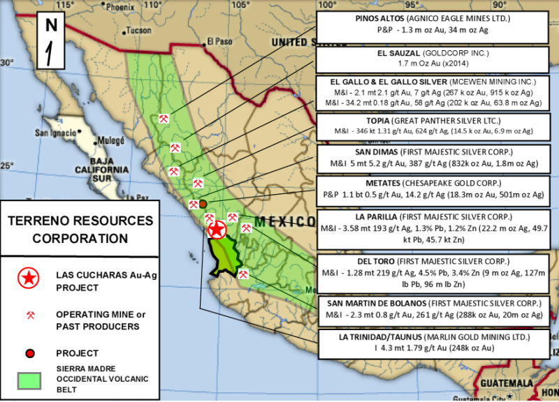
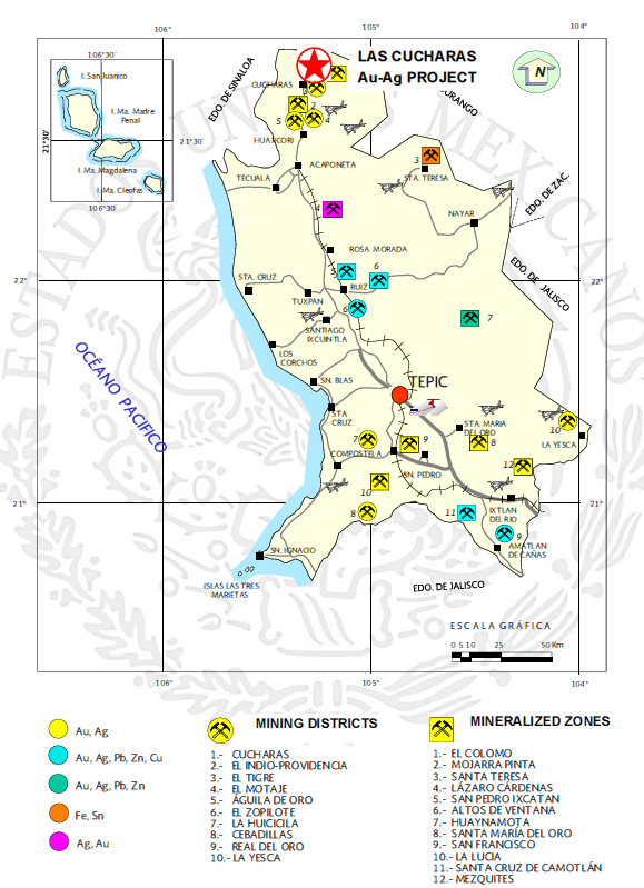
Las Cucharas is a historic gold and silver mining area, with well documented small-scale production from 1903 through 1961 of 3,000 kilograms of gold and 30,000 kilograms of silver (Vargas, 1994, COREMI Pub M-12e). It is located in the southern extreme of the mid-Tertiary Sierra Madre Occidental (SMO) volcanic belt, which hosts many of Mexico's most significant gold and silver deposits (SEE MAP 1).The state of Nayarit in Mexico is host to several important producing mines, past producing mines, and well known mineralized districts (SEE MAP 2).
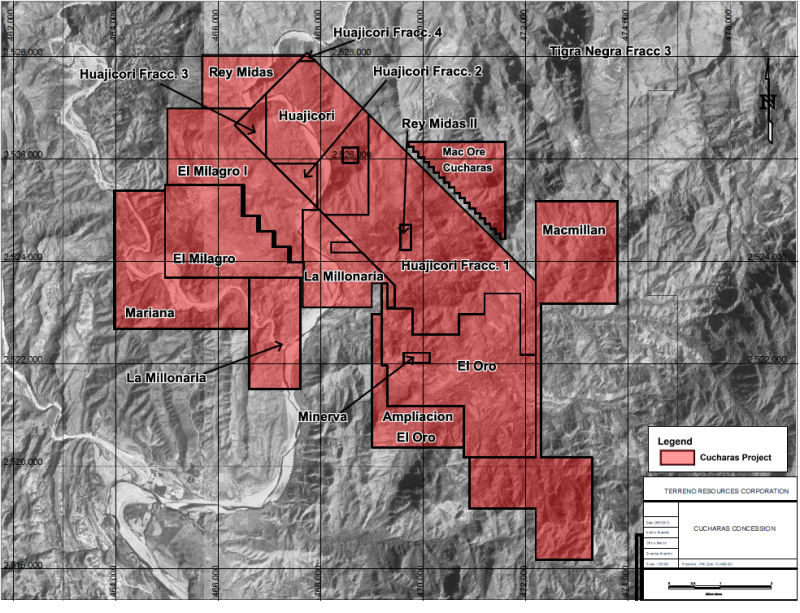
The Las Cucharas project area is 4,447 hectares covered by seventeen (17) concessions (SEE MAP 3). Significant underground workings have been developed at several different zones, including La Union, El Cardon, Los Gallos, Jocuixtle, La Italia, and La Raizura. These workings are often hundreds of metres in length and developed on several levels. Most of the remaining known showings have exploratory adits.
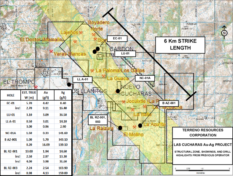
The Las Cucharas Project is classified as a volcanic-hosted low-sulfidation epithermal precious metal system, with significant mineralization occurring along a six kilometre northwest-trending structural zone. Gold and silver are hosted in vein and shear structures, stockwork zones, and breccias. Classic low sulfidation textures are common, including banded quartz veins and breccias, as well as drusy, bladed, and chalcedonic quartz. Historical exploration work was carried out by Maverix Metals Inc. (formerly MacMillan Minerals Inc. and the predecessor company MacMillan Gold Corp.) between 2003 through 2012. This work succeeded in identifying fourteen separate mineralized showings.
Maverix carried out several phases of surface and underground geological mapping, rock and soil sampling, trenching, local geophysics, and drilled approximately 2,190 metres in 15 exploration diamond drill holes (SEE MAP 4).
Some work highlights include:
|
HOLE
|
ZONE
|
FROM (m)
|
TO (m)
|
DRILL WIDTH (m)
|
EST. TRUE W (m)
|
Au (g/t)
|
Ag (g/t)
|
|
BL RZ-001
|
LA RAIZURA
|
96.5
|
110.0
|
13.5
|
13.0
|
1.94
|
14.6
|
|
BL RZ-003
|
LA RAIZURA
|
77.6
|
84.8
|
7.2
|
2.2
|
2.54
|
103.9
|
|
B AZ-001
|
LA AZURITA
|
12.2
|
13.2
|
1.0
|
-
|
5.7
|
343.1
|
|
LU-01
|
LA UNION
|
64.3
|
67.5
|
3.2
|
3.1
|
3.09
|
36.5
|
|
EC-01
|
EL CARDON
|
157.5
|
165
|
7.5
|
5.7
|
4.42
|
8.4
|
These exploration results evaluated along with the historic production clearly demonstrates significant precious metal potential at Las Cucharas, and Terreno's management is very pleased to be working on a project of this quality.
Mr. Cary Pothorin, Vice President of Exploration for Terreno Resources Corporation, a Qualified Person as defined in Nation Instrument 43-101, has prepared and approved the scientific and technical disclosure contained in this news release.
Additional information on the Company can be viewed at www.sedar.com
For additional information, contact: Tel: (905) 467-1109
Email: georgeabrown0955@gmail.com
Suite 1102, 44 Victoria Street, Toronto, Ontario M5C 1Y2
Neither The TSX Venture Exchange nor its Regulation Services Provider accepts responsibility for the adequacy or accuracy of this release.
This release may contain certain "forward looking statements" and certain "forward-looking information" as defined under applicable Canadian and U.S. securities laws. Forward-looking statements and information can generally be identified by the use of forward-looking terminology such as "may", "will", "expect", "intend", "estimate", "anticipate", "believe", "continue", "plans" or similar terminology. Forward-looking statements and information include, but are not limited to, statements with respect to the transactions contemplated, any requisite regulatory approvals in respect thereof and proposed future transactions Terreno may undertake and their expected timing. Forward-looking statements and information are based on forecasts of future results, estimates of amounts not yet determinable and assumptions that, while believed by management to be reasonable, are inherently subject to significant business, economic and competitive uncertainties and contingencies. Forward-looking statements and information are subject to various known and unknown risks and uncertainties, many of which are beyond the ability of Terreno to control or predict. Terreno undertakes no obligation to update forward-looking information except as required by applicable law. Such forward-looking information represents management's best judgment based on information currently available. No forward-looking statement can be guaranteed and actual future results may vary materially. Accordingly, readers are advised not to place undue reliance on forward-looking statements.

Click Image To View Full Size
MAP 1 - Location of Las Cucharas Project in relation to significant gold and silver mines and deposits in the Sierra Madre Occidental (SMO) volcanic belt in Western Mexico.

Click Image To View Full Size
MAP 2 - Deposits and mineralized zones in the state of Nayarit, Mexico. (Ref: SGM, Panorama Minero del Estado de Nayarit Diciembre 2016)

Click Image To View Full Size
MAP 3 - Las Cucharas project area showing outline of concessions, covering over 4,447 hectares. Each map grid block is 2 km x 2 km.

Click Image To View Full Size
MAP 4 - Light yellow shading indicates NW-trending structural zone and location of main showings. Black dots indicate location of historical exploration drill holes and corresponding intersections.
Copyright (c) 2020 TheNewswire - All rights reserved.