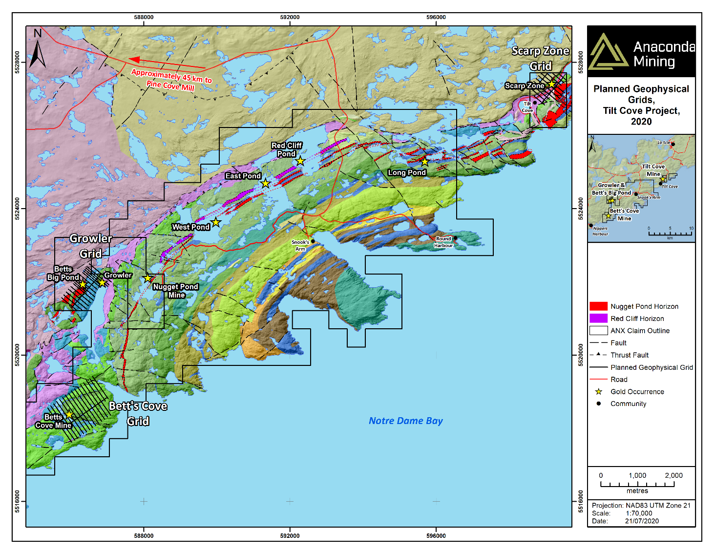
TORONTO, ON / ACCESSWIRE / July 21, 2020 / Anaconda Mining Inc. ("Anaconda" or the "Company") (TSX:ANX) (OTCQX:ANXGF) is pleased to announce the initiation of a 35-line kilometre geophysical survey and 10,000 metre diamond drill program at the Tilt Cove Gold Project ("Tilt Cove"), located within the Baie Verte Mining District in Newfoundland, approximately 45 kilometres by road from the Company's Pine Cove Mill and tailings facility (Exhibit A). Tilt Cove is a significant, recently consolidated land package encompassing the same geological trend as the past producing, high-grade Nugget Pond Mine, which had an average recovered grade of 9.85 grams per tonne ("g/t") gold. Tilt Cove covers a 20-kilometre strike extent of the Betts Cove Complex, a highly prospective geological terrane including the Nugget Pond Horizon ("NPH"), the iron-rich sedimentary unit that hosts the past-producing Nugget Pond Mine (Exhibit A).
"As a result of the recently announced $5.51M private placement, we are immediately and aggressively executing on our goal of discovering a high-grade deposit at our prospective Tilt Cove Gold Project. With the success of previous field work, all within sight of a past producing high-grade gold mine, we are confident that Tilt Cove has more high-grade gold to offer. We have commenced a 35-line kilometre ground magnetic and IP geophysical survey with crews now mobilized in the field. Furthermore, we will be testing at least five priority targets over the next six months with 10,000 metres of diamond drilling. The recent financing and the ability to accelerate our work at Tilt Cove makes this an exciting time for Anaconda and is consistent with our strategy to leverage the Pine Cove Mill and permitted tailings facility, fast-tracking the period from discovery to production and realizing full shareholder value from new discoveries."
~ Kevin Bullock, President and CEO, Anaconda Mining Inc.
Tilt Cove Project Advancements to Date
To date, Anaconda has made the following advances at Tilt Cove:
- Discovered the new Growler Showing with channel samples that include 2.75 g/t gold over 5.2 metres and 1.78 g/t gold over 5.0 metres (see Table 1 below for full results);
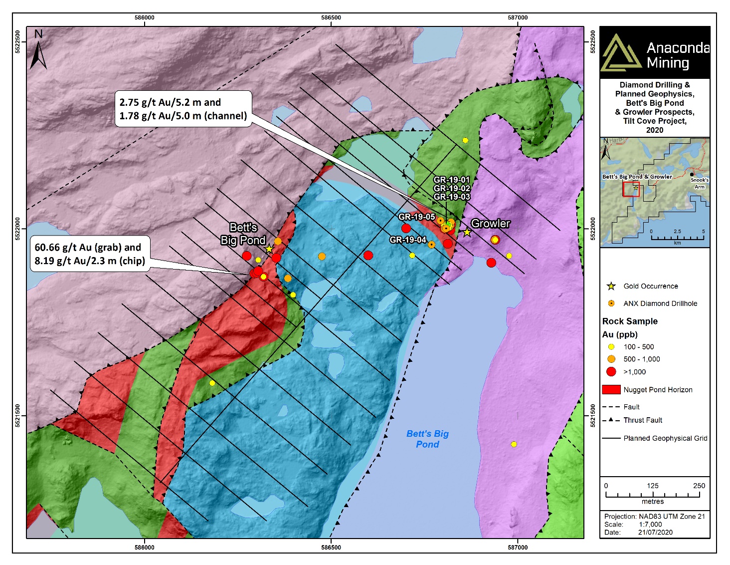
- Discovered an additional 2 kilometres of prospective strike in the Growler area that includes the NPHwhich is host to two significant showings: the Growler Showing and the Betts Big Pond Showing which has historic grab samples up to 60.66 g/t gold and chip samples of 8.19 g/t gold over 2.3 metres. These Nugget Pond-style showings are within 400 metres of each other and are broadly considered part of the new Growler target area (Exhibit B);
- Discovered a new prospective iron-rich horizon, the Red Cliff Horizon, in the footwall of the Nugget Pond Horizon with a 6 kilometre strike, establishing two potential host rocks for Nugget Pond-style gold mineralization in this area (Exhibits A and C);
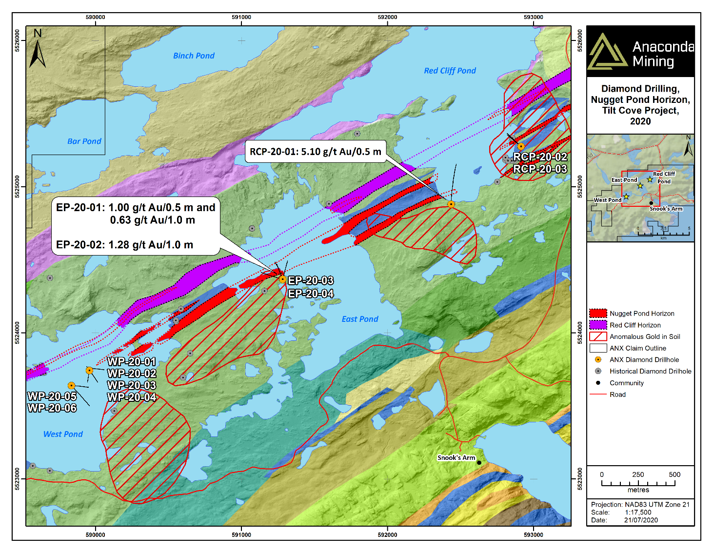
- Developed multiple drill targets associated with coincident structures that cross the Nugget Pond and Red Cliff Horizons, with coincident magnetic lows and gold-in-soil anomalies located along the southeast trend of historic glacial movement ("down-ice") (Exhibit C);
- Identified a broad gold-in-soil anomaly down-ice from the Red Cliff Pond Target (Exhibit C);
- Found 154 rock grab and float samples with anomalous gold (82 samples greater than 0.50 g/t gold, 31 greater than 3.00 g/t gold and 14 high-grade samples ranging from 5.16 g/t gold to 216.10 g/t gold) and two visible gold occurrences (previously announced; see press release dated November 27, 2019);
- Conducted a LiDAR survey over the entire property and a detailed drone magnetic survey (453 line-kilometres) covering the NPH; and
- Conducted 2,975 metres of diamond drilling in 18 drill holes at the Red Cliff Pond, East Pond, West Pond and Growler targets and intersected prospective host rocks, anomalous gold, geological structures and quartz veins with associated sulfides, all typically associated with Nugget Pond-style gold mineralization (Exhibits B and C).
Geophysical crews are now mobilized at Tilt Cove to conduct a combined 35-line kilometre ground magnetic and IP geophysical survey. This work will be coincident with a mapping and prospecting program, which will be followed by a 10,000-metre diamond drill program at highly prospective targets including the Scarp, West Pond, Growler, East Pond and Betts Cove targets (collectively referred to as the "2020 Tilt Cove Program").
The 2020 Tilt Cove Program
The 2020 Tilt Cove program will test the top five priority targets on the Tilt Cove Project as well as collect data from other targets to advance them to the drill stage. The top five priority targets include the Scarp Zone, West Pond, Betts Cove, Growler and East Pond (Exhibit A). 35-line kilometres of ground geophysics (magnetics and IP) and 10,000 metres of diamond drilling will test the priority targets as follows:
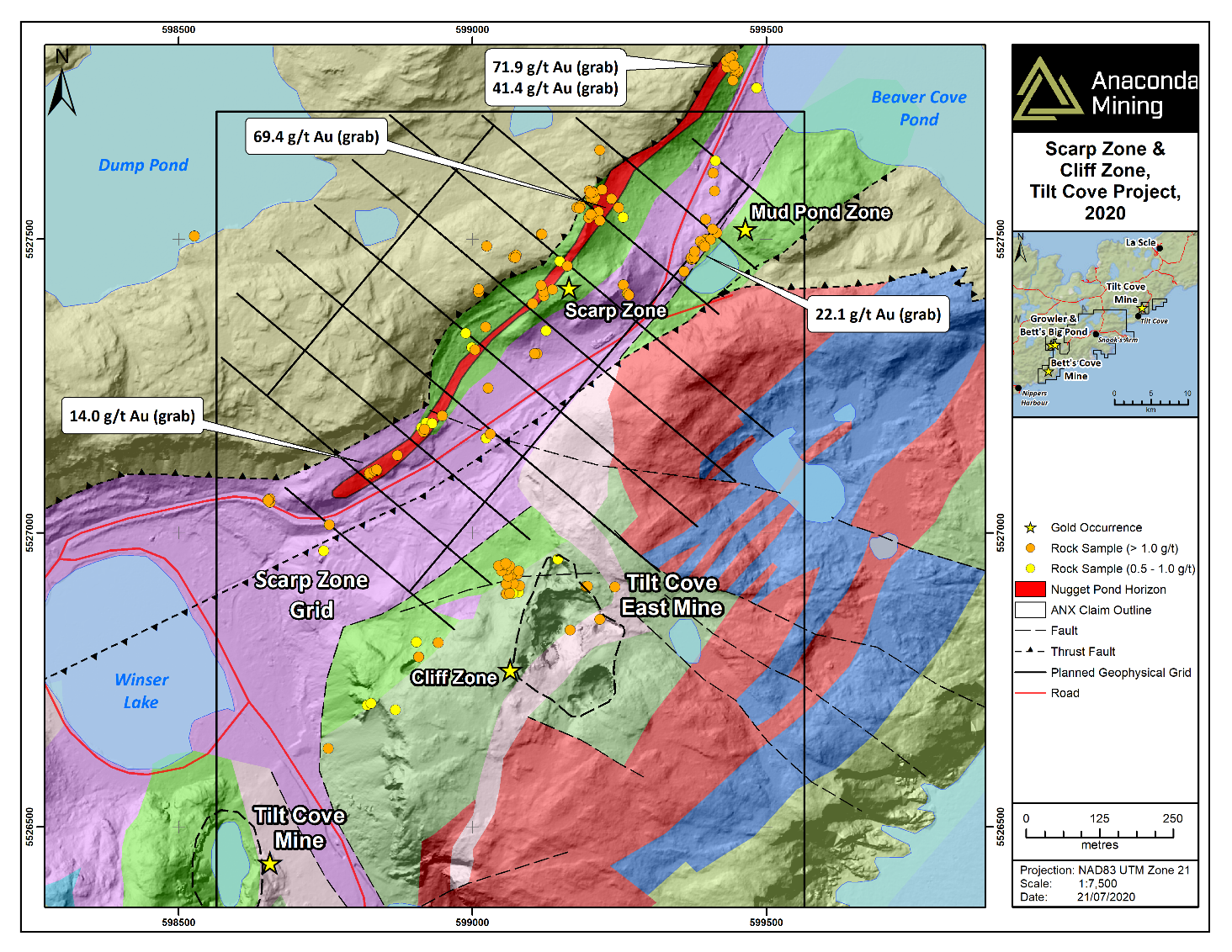
The Scarp Zone - This target is characterized by more than a kilometre of exposed NPH coincident with a similar strike length consisting of 107 gold bearing rock grab and float samples over 0.5 g/t gold (Exhibit D). The area is also characterized by a strong deformation zone adjacent to the Nugget Pond Horizon which dips shallowly northwest beneath younger Silurian rocks. This target will be tested with 6.2 kilometres of ground magnetic and IP geophysics as well as 2,500 metres of diamond drilling and 500 metres of percussion drilling.
West PondTarget - This target is characterized by a 1.3-kilometre long zone beneath West Pond that is up-ice from a very strong gold-in-soil anomaly very similar in character and dimension to the gold-in-soil anomaly associated with the discovery of the high-grade Nugget Pond Deposit as well as a coincident break in magnetic intensity where a north-westerly trending lineament intersects the NPH. West Pond will be tested using 2,000 metres of diamond drilling that will be drilled either from shore or from a barge.
Betts Cove Target - At the Betts Cove Mine disseminated to massive pyrite and chalcopyrite +/- gold mineralization is hosted at the contact between gabbroic sills and pillow basalts, particularly within a chlorite schist unit that may represent a sheared alteration zone; a similar setting to the Tilt Cove Mine 20 kilometres to the northeast along strike. Historic drilling at the Betts Cove Mine has returned significant gold intercepts that include: 4.48 g/t gold over 4.0 metres (from 52.0 to 56.0 metres), including 11.20 g/t gold over 1.1 metres in hole BC-89-01; 6.77 g/t gold over 5.0 metres (from 63.1 to 68.1 metres) in hole BC-89-02; 1.87 g/t gold over 13.0 metres (from 63.5 to 76.5 metres) including 7.50 g/t gold over 0.5 metres and 8.82 g/t gold over 1.0 metre in hole NBC-96-01; and 4.59 g/t gold over 1.5 metres (from 63.5 to 65.0 metres) in hole NBC-96-02. 17.6-line kilometres of IP geophysics and up to 1,500 metres of diamond drilling will test this area.
Growler Target - The Growler Target is a newly recognized zone of prospectivity with a strike of 2 kilometres underlain by the NPH and associated with two large shear zones adjacent to the NPH contact. The area also includes recently discovered surface mineralization with channel samples at the Growler Showing assaying 2.75 g/t gold over 5.2 metres and 1.78 g/t gold over 5.0 metres as well as historic chip samples at the Betts Big Pond Showing assaying 8.19 g/t gold over 2.3 metres. 11.1-line kilometres of IP geophysics and up to 2,500 metres of diamond drilling will test this area.
East Pond- East Pond is characterized by an 800-metre strike length of the NPH coincident with reduction in magnetic intensity and cross cutting lineaments. The target also includes historic drilling, which intersected footwall mineralization similar to the Nugget Pond Mine including 5.74 g/t gold over 0.5 metres (RCP-97-01); 10.30 g/t gold over 0.5 metres (RCP-97-02); 1.16 g/t gold over 3.4 metres (RCP-97-02); and 4.90 g/t gold over 0.5 metres (RCP-98-01). 1,500 metres of drilling is designed to test the East Pond target.
The Winter Program
On November 27, 2019 and February 27, 2020, the Company announced an exploration program at Tilt Cove that intended to include 4,000 metres of diamond drilling in addition to a trenching program at Growler (collectively the "Winter Program"). A large portion of the Winter Program was not completed due to concerns over ice conditions required for drilling on the ponds and other factors related to the COVID-19 pandemic. The Company was able to complete the trenching at Growler and 2,975 metres of diamond drilling in 18 holes across four targets at Tilt Cove.
Growler Exploration - During late fall 2019, the Company completed a short trenching program exposing the Growler Showing based on results of grab sampling earlier that summer. Trenching exposed an area of altered and pyrite mineralized sediments that the Company interprets to be a thrust repeated section of the NPH. A total of 47 channel samples averaging 1.0 metre in length were cut in various orientations across the Growler exposure (Exhibit B). The best channel sample results include 2.75 g/t gold over 5.2 metres and 1.78 g/t gold over 5.0 metres (Table 1).
Table 1. Select Composited Channel Sample Results from the Growler Showing.
|
Channel ID
|
Interval (m)*
|
Au (g/t)
|
|
1
|
5.00
|
1.78
|
|
including
|
2.00
|
2.86
|
|
2
|
5.20
|
2.75
|
|
including
|
2.00
|
6.05
|
|
3
|
6.00
|
1.38
|
|
including
|
1.00
|
3.71
|
|
5
|
2.00
|
2.17
|
|
including
|
2.00
|
3.62
|
*True thickness unknown
In December 2019, a total of 375 metres of diamond drilling in five shallow holes (GR-19-01 to 05) was completed to test the mineralization exposed in trenching at the Growler Showing. The drill holes were designed to test the down-dip projection of mineralization and the trend of major host structures within the trench area. Although drilling failed to intersect the grades and thicknesses observed in the trench, the Company intends on fully testing the Growler area as it represents a structural repeat of the NPH, and along with the Betts Big Pond Showing, represents an area of excellent exploration potential. Weakly anomalous gold was returned from drill hole GR-19-01 (Table 2).
Red Cliff Pond Drilling - A total of 843 metres of diamond drilling was completed in three holes (RCP-20-01 to 03) to test priority geophysical signatures (coincident IP chargeability highs and magnetic lows) at the Red Cliff Pond Target (Exhibit C). Drilling successfully intersected the NPH sediments with alteration, quartz veining, pyrite mineralization and structures (faults and shear zones) that are amenable to hosting gold mineralization. Assays included 5.10 g/t gold over 0.5 metres (97.8 to 98.3 metres) in hole RCP-20-01 (Table 2).
East Pond Drilling - A total of 763 metres of diamond drilling was completed in four holes (EP-20-01 to 04) to test priority geophysical signatures (coincident IP chargeability highs and magnetic lows) at the East Pond Target (Exhibit C). Drilling successfully intersected the NPH sediments with quartz veining, multiple generations of pyrite mineralization and structures (brecciation, faults and shear zones) that are amenable to hosting gold mineralization. Weakly anomalous zones of gold mineralization hosted in quartz veined gabbro sills associated with the NPH were encountered in holes EP-20-01 and 02 (Table 2).
West Pond Drilling - A total of 998 metres of diamond drilling was completed in six holes (WP-20-01 to 06) from the ice to test priority geophysical signatures (magnetic lows), structural and geochemical anomalies (soil, rocks and tills down-ice to the southeast) at the West Pond Target (Exhibit C). Drilling successfully intersected the NPH sediments with quartz veining, multiple generations of pyrite mineralization and structures (brecciation, faults and shear zones) that are amenable to hosting gold mineralization. Geological interpretation of drill results suggests tight- to isoclinal-folding of the NPH in this area, increasing the thickness of the potential target. Deteriorating ice conditions in early March and the onset of the COVID-19 pandemic prevented the Company from fully testing targets beneath and adjacent to West Pond. No significant assays were returned from initial drilling at West Pond.
Table 2. Assay Highlight Table from the Winter Program at the Tilt Cove Project.
|
Drill Hole
|
From (m)
|
To (m)
|
Interval (m)*
|
Au (g/t)
|
|
GR-19-01
|
24.0
|
25.0
|
1.0
|
0.59
|
|
RCP-20-01
|
97.8
|
98.3
|
0.5
|
5.10
|
|
EP-20-01
|
120.7
|
121.7
|
1.0
|
0.63
|
|
EP-20-01
|
159.5
|
160.0
|
0.5
|
1.00
|
|
EP-20-02
|
154.0
|
155.0
|
1.0
|
1.28
|
*True thickness unknown
This news release has been reviewed and approved by Paul McNeill, P. Geo., VP Exploration with Anaconda Mining Inc., a "Qualified Person", under National Instrument 43-101 Standard for Disclosure for Mineral Projects.
All samples and the resultant composites referred to in this release were collected using QA/QC protocols including the regular insertion of certified standards and blanks within each sample batch sent for analysis and completion of check assays of select samples. Diamond drill core and channel samples were analyzed for Au at Eastern Analytical Ltd. in Springdale, NL ("Eastern"), using standard fire assay (30 g) pre-concentration and Atomic Absorption finish methods. Eastern is a fully accredited firm within the meaning of NI 43-101 for provision of this service.
Mineralized intervals referred to in this press release are reported as drill and channel intersections and are apparent widths only. Not enough drilling has been completed to fully interpret true width at this time.
Composited assays from historical drill core are compiled from historic reports and data filed with the Department of Natural Resources, Newfoundland and Labrador. Sufficient work has not been completed by Anaconda geologists and QPs to validate these composited assays. Rock "grab" and "float" samples are selected samples and are not necessarily indicative of mineralization that may be hosted on the property.
A version of this press release will be available in French on Anaconda's website (www.anacondamining.com) in two to three business days.
ABOUT ANACONDA
Anaconda is a TSX and OTCQX-listed gold mining, development, and exploration company, focused in Atlantic Canada. The company operates mining and milling operations in the prolific Baie Verte Mining District of Newfoundland which includes the fully-permitted Pine Cove Mill, tailings facility and deep-water port, as well as ~11,000 hectares of highly prospective mineral lands including those adjacent to the past producing, high-grade Nugget Pond Mine at its Tilt Cove Gold Project. Anaconda is also developing the Goldboro Gold Project in Nova Scotia, a high-grade resource and the subject of an on-going feasibility study.
FORWARD-LOOKING STATEMENTS
This news release contains "forward-looking information" within the meaning of applicable Canadian and United States securities legislation. Generally, forward-looking information can be identified by the use of forward-looking terminology such as "plans", "expects", or "does not expect", "is expected", "budget", "scheduled", "estimates", "forecasts", "intends", "anticipates", or "does not anticipate", or "believes" or variations of such words and phrases or state that certain actions, events or results "may", "could", "would", "might", or "will be taken", "occur", or "be achieved". Forward-looking information is based on the opinions and estimates of management at the date the information is made, and is based on a number of assumptions and is subject to known and unknown risks, uncertainties and other factors that may cause the actual results, level of activity, performance or achievements of Anaconda to be materially different from those expressed or implied by such forward-looking information, including risks associated with the exploration, development and mining such as economic factors as they effect exploration, future commodity prices, changes in foreign exchange and interest rates, actual results of current production, development and exploration activities, government regulation, political or economic developments, environmental risks, permitting timelines, capital expenditures, operating or technical difficulties in connection with development activities, employee relations, the speculative nature of gold exploration and development, including the risks of diminishing quantities of grades of resources, contests over title to properties, and changes in project parameters as plans continue to be refined as well as those risk factors discussed in Anaconda's annual information form for the year ended December 31, 2019, available on www.sedar.com. Although Anaconda has attempted to identify important factors that could cause actual results to differ materially from those contained in forward-looking information, there may be other factors that cause results not to be as anticipated, estimated or intended. There can be no assurance that such information will prove to be accurate, as actual results and future events could differ materially from those anticipated in such information. Accordingly, readers should not place undue reliance on forward-looking information. Anaconda does not undertake to update any forward-looking information, except in accordance with applicable securities laws.
FOR ADDITIONAL INFORMATION CONTACT:
Anaconda Mining Inc.
Kevin Bullock
President and CEO
(647) 388-1842
kbullock@anacondamining.com
Reseau ProMarket Inc.
Dany Cenac Robert
Investor Relations
(514) 722-2276 x456
Dany.Cenac-Robert@ReseauProMarket.com
Anaconda Mining Inc.
Lynn Hammond
VP, Corporate Affairs
(709) 330-1260
lhammond@anacondamining.com

Exhibit A. A map showing the location of the Tilt Cove Project, as well as high priority exploration targets referenced in the press release, including the Growler Showing East, West and Scarp Zone Targets.

Exhibit B. A map outlining the extent of the Growler area, showing two kilometers of prospective strike associated with the NPH and including the recently discovered Growler and Betts Big Pond showings. Drill holes and results of recent channel samples and historic chip samples are show for the Growler and Betts Big Pond Showings.

Exhibit C. A map showing the location of high priority exploration targets including drill holes from the Winter Program at the West Pond, East Pond and Red Cliff Pond. Gold-in-soil anomalies are shown in red polygons and are located down-ice (southeast) of the Nugget Pond and Red Cliff Horizons. The Nugget Pond Deposit was situated immediately up-ice of a similar gold-in-soil anomaly.

Exhibit D. A map showing the Scarp Zone characterized by more than a kilometre of anomalous gold samples greater than 0.5 g/t gold, a strong deformation zone and associated with a past producing, gold rich base metal mine (the Tilt Cove Mine).
SOURCE: Anaconda Mining Inc.
View source version on accesswire.com:
https://www.accesswire.com/598163/Anaconda-Mining-Ramps-Up-Exploration-Program-At-Tilt-Cove-Gold-Project-Including-IP-Geophysical-Survey-And-10000-Metres-Of-Diamond-Drilling
