Join today and have your say! It’s FREE!

Become a member today, It's free!

We will not release or resell your information to third parties without your permission.
Please Try Again
{{ error }}
By providing my email, I consent to receiving investment related electronic messages from Stockhouse.

or

Sign In

Please Try Again
{{ error }}
Password Hint : {{passwordHint}}
Forgot Password?

or

Please Try Again {{ error }}

Send my password

SUCCESS
An email was sent with password retrieval instructions. Please go to the link in the email message to retrieve your password.

Become a member today, It's free!

We will not release or resell your information to third parties without your permission.

Aston Bay Holdings Ltd V.BAY

Alternate Symbol(s):  ATBHF

Aston Bay Holdings Ltd. is a Canada-based mineral exploration company exploring high-grade copper and gold deposits in Virginia, United States, and Nunavut, Canada. The Company is exploring the high-grade Buckingham Gold Vein in central Virginia and is in advanced stages of negotiations on other lands with high-grade copper potential in the area. The Company is focused on its Blue Ridge Project in Virginia. The Nunavut Property is 100% owned by the Company and located 112 kilometers (km) south of the community of Resolute Bay, Nunavut on western Somerset Island. The Storm Copper Project is located on Somerset Island, Nunavut, approximately 20 km from tidewater at the Company. Its Seal Zinc deposit is located at the base of a small peninsula approximately 350 meters from tidewater at its on Somerset Island, Nunavut. Its Mountain Base Metals Project is located on 2,072 acres of private land with direct access to both highway and rail transportation.


TSXV:BAY - Post by User

Post by traps7on Apr 06, 2023 10:56am
84 Views
Post# 35382997

Historic drill hole intercepts 2750

Historic drill hole intercepts 2750

just to re-cap here , the 9 drill holes from last summer seen here , looking at Legend , notice the black dots are old core collars and last summers. The Blue dots are the planned new drill locations and notice here the blue dots are in[between the blackdots.

The new driling is called in-fill drilling which proves up the continuity between the holes at a shorter distance . The shorter distace between holes over a larger distance would be called a indicated reserve in my opinion..

Notice also on slide in Legend box, the colour purple designates copper % over 2 % which we see here on image the 2750 zone appears purple through-out which we know all previous core was all over 2%.. The 2750 area seen here on image over laps a checker board meaning each drill hole would fit onto a square on the board. Now add a number on each square and your on tour way to making a 43-101  
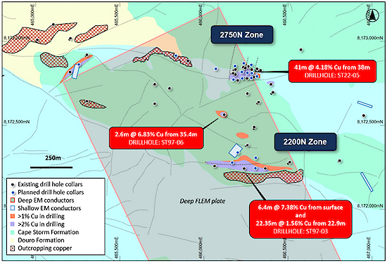

Figure 3: Plan view of the 2750N and 2200N Zones showing copper mineralization footprint defined by drilling and EM anomalies, overlaying regional geology. Stated drill hole intersections are all core length, and true width is expected to be 60% to 95% of core length.

<< Previous
Bullboard Posts
Next >>