just to re-cap here , the 9 drill holes from last summer seen here , looking at Legend , notice the black dots are old core collars and last summers. The Blue dots are the planned new drill locations and notice here the blue dots are in[between the blackdots.
The new driling is called in-fill drilling which proves up the continuity between the holes at a shorter distance . The shorter distace between holes over a larger distance would be called a indicated reserve in my opinion..
Notice also on slide in Legend box, the colour purple designates copper % over 2 % which we see here on image the 2750 zone appears purple through-out which we know all previous core was all over 2%.. The 2750 area seen here on image over laps a checker board meaning each drill hole would fit onto a square on the board. Now add a number on each square and your on tour way to making a 43-101
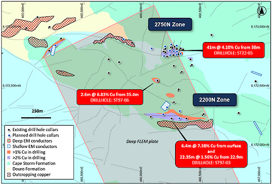
Figure 3: Plan view of the 2750N and 2200N Zones showing copper mineralization footprint defined by drilling and EM anomalies, overlaying regional geology. Stated drill hole intersections are all core length, and true width is expected to be 60% to 95% of core length.