booming intersection of massive copper sulfides “This booming intersection of massive copper sulfides and copper sulfide-filled breccias in the near-surface has been aptly named ‘Thunder.’ With clear similarities to the high-grade mineralization of the 2750N Zone located over 1km to the east, this zone points to the potential for additional high-grade near-surface resources to add to the delineation program currently underway.
The drill hole highlights the outstanding exploration and expansion potential of both the near-surface, potentially open-pit accessible mineralization, and the deeper, large-scale sedimentary copper system.
The exceptional and thick upper copper sulfide mineralization within ST23-03 is more intense than the similar-looking, high-grade 2750N Zone mineralization (intersections include 41m @ 4.18% Cu within ST22-05), which is located over 1km to the east (Figures 2 & 3). The entire 76m interval in ST23-03 is heavily mineralized and includes a 22m thick zone of banded semi-massive to massive sulfides (Figures 1 & 4). The massive sulfides are interpreted to be the source of the MLEM anomaly. This geophysical method detects electrical conductance in high-sulfide content rock (typically >6% sulfide), which is typically contained within larger volumes of lower-sulfide, but still strongly mineralized, rock.
The upper zone of copper mineralization encountered within ST23-03 is a 76m thick interval of strong breccia and vein-style copper sulfides, with broad zones of semi-massive to massive sulfide from 32m downhole. The massive sulfides are dominantly chalcocite, with bornite and chalcopyrite (Figures 1 & 4), and represent a significant new discovery of near-surface copper mineralization.
The thickness and intensity of the mineralization of the new zone (now named ‘Thunder’), and high-grade 2750N and 2200N Zones along strike to the east, suggest that this high-grade mineralization and structural setting may be directly related to their proximity to the Southern Graben Fault. These faults are interpreted to be the primary source of plumbing for both the near-surface, and deeper copper mineralization.
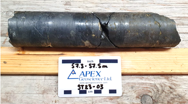
Figure 4: Massive chalcocite (dark grey) in drill hole ST23-03 from approximately 57.4m downhole.
The lower zone of mineralization was intersected at 273m downhole and is interpreted to correlate with the sediment hosted copper mineralization intersected in drill holes ST22-10, ST23-01 and ST23-02. The 2m mineralized interval consists of broad fractures and dense anastomosing veins of chalcocite, bornite and chalcopyrite (Figure 5).
The copper sulfides are hosted within a sequence of organic rich and vuggy dolomudstones that are visually very similar to ST22-10, ST23-01 and ST23-02.
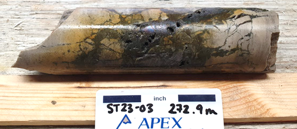
Figure 5: Breccia chalcocite (dark grey), bornite (purple/grey) and chalcopyrite (brassy) in drill hole ST23-03 from approximately 272.9m downhole.
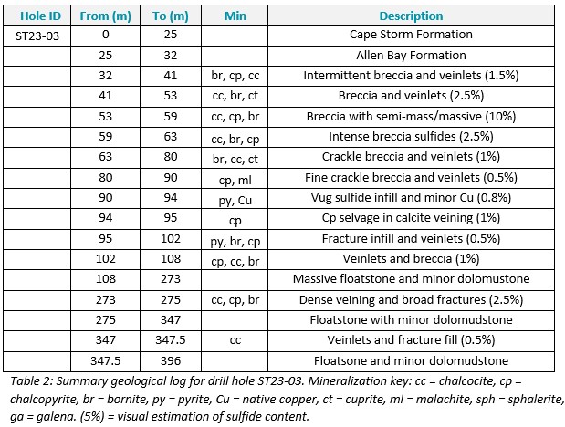

Figure 6: NW – SE geological section through drill hole ST23-03.
PLANNED PROGRAM
.
Let The Drills Be Our Friends
Traps7