Now don't laugh.
I was closing several research window to speed up the computer...
And lo and behold.. . Imperial window was next - and yes.. i scanned it one more time.
Ha.
Before i begin... i'll admit...
I'm a macro lense sort of researcher.
I look for the larger connective then, i go micro.
Macro sets the scene.. . hoepfully there's something ( geology wise )
that leads to another connective.
Macro - provides a window into the past - while micro - one can get lost if they use this firstly.
Once on the ground - you can't see the forest for the, trees.
I fele for some of the junors - becase once on the ground - it don't look anything like the maps.
Exploring is not easy...
So... let's revisit - McBride. Why - because i saw something - interesting...
Something - that might be a connective to the - dogleg.
lol
Imperial has a - RedChris - copper trend map - Copper trend runs north east - south west.
I travelled north - found - ISKUT - went a tad east and found the - McBride - arrow shape.
Dog lleg is in between the flat arrow shapeed head - and the black larger mound.
Right out of the gates - Imperial has a copper ( red marker ) that runs right into McBride.
Indicating copper does track into - McBride.
GEO PUZZLE SHIFTING Yes... i do - do this...when, trying to understand a particluar zone.
Sometimes - - geo landscapes -- - shift / drop / elevate, contort, twist, etc...
If there's larger mountains to the west. of McBride....
Then, watershed, seismic activity / faults - will do their best - rershaping the landscape.
Now... if one plays with the geo land masses - there are a few hints that the pieces
match in other areas and have shifted.
i won't get into it- as it would require a novel to explain...lol
Main premise... Imperial has the red copper trend " kissing " McBride.
It would be interesting to see what other survey maps they have - most likely some serious
money was dropped to track the copper trend.
Sharp eyes will notice the - black " arrow " imposed on the map - pointing to McBride.
Where it reads - red chris in white lettering - this island mass could be moved a tad westerly.
Also squished tighter to McBride....
What would be the result ?
A tighter correlation to the redchris - copper trend and McBride .
The larger McBride - black mound - would be prime - to explore for the copper continuence.
Why did i always say the inside - dog leg ?
Well it's still right asdie of trhe large black mound.
Inside facing north west - the area be tween the lighteer arrow and the dark mound.
Simply put - the base of this would allow the junior to test tilled soils that come fro mthe lighter arrow and at same time test the tills from the darker mound.
two birds one stone.
Now that i actually see a better visual of this area . google was just too dark -
i would say yes.. check the inside dog leg. and if the till ores present any copper findings...
Drill the dark mound from - top down.
Where's the map...? i knew you'd ask... tease.
link to open larger https://www.imperialmetals.com/assets/thumbnails/2021-03-15-red-chris-gj-property-s-w256-h190-q70-m1615852180.jpg
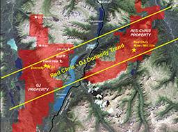
If one is really energetic - look where NewCrest is sending Imperial - to search for copper.
GJ Propert.
Way the he-ll away frrom thier - main mine site.
Silly... will be difficult to transport ores back to redchirs mine .
Makes no sense...
NewCrest would be all the wiser to - at least - tap a few holes on McBride.
dark mound - inside leg.
If one is really, really energetic.... Puzzle match the GJ zone with the Redchris zone - see what you come up with.
I tend t olean towards... McBride does connect to the redchris...
JUst an opinion... I mayber wrong... but then again, i maybe right.
Cheers...